This burial ground was designated as “six feet square” and mentioned for the first time in Deed Book 58, Page 511 (W.S. Mitchell to M.B. Martin in 1890 – lot 69’ X 131’). “…..But there is expressly excepted from this conveyance a parcel of land six feet square on the northwest side of an apple tree standing on said tract of land above described…..”
The two children who were buried there were moved to an unnamed location.
See further details in the DEEDS section, which will clarify how the name was established. Also, see the BURIALS section for a calculated determination of who was buried there.
It should be noted that although significant research went into this record, some doubt of specifics could possibly exist.
LOCATION –
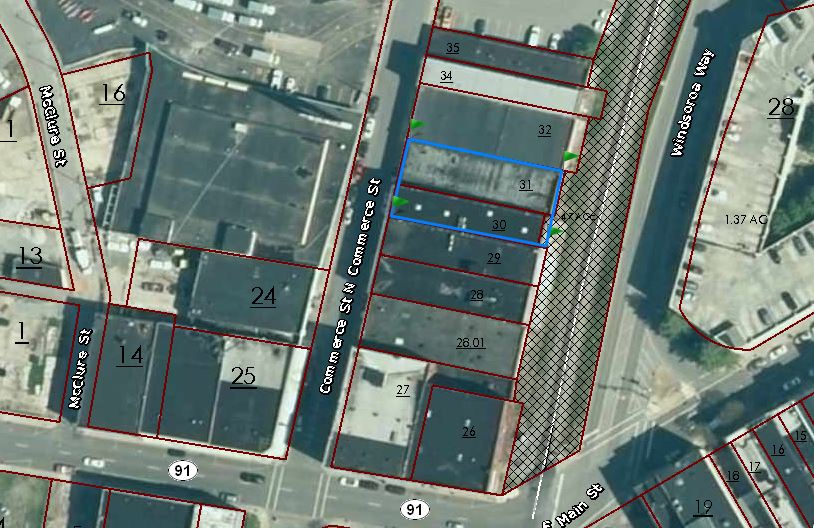
It was located somewhere on a 69’ X 131’ parcel. This 69’ X 131’ parcel is currently designated as Washington County tax parcels 046NL030.00 at 119 Commerce Street and 046NL031.00 at 117 Commerce Street. No specific GPS can be provided.
DEEDS –
Utilizing the deed found at Deed Book 58, Page 511 as a starting point, then working backward and forward, a rather complete succession has been established.
Tipton Jobe conveyed to Smith Hale (Deed Book 44, Page 203 – 1859 but not recorded until 1874) a parcel of several acres north of West Market Street, west of the tracks, and south & east of Brush Creek.
Smith Hale sold off various smaller parcels of this tract. Only those pertinent to the placement of the burial ground are presented.
Smith Hale to Winfield S. Mitchell, James Mitchell, and Margaret Mitchell (Deed Book 43, Page 529 – 1873 – a 69’ X 100’ parcel). James and Margaret convey their interests to W S Mitchell (Deed Book 52, Pages 137 & 138 – 1885). These deeds all silent on a burial ground.
Smith Hale to Winfield S Mitchell (Deed Books 60 & 63, Pages 241 & 247 – 1888 but not recorded until 1890 & 1891 – a 31’ X 69’ parcel). Silent on burial ground.
Winfield S. Mitchell now owns the entire 69’ X 131’ parcel – year is 1888.
Winfield S Mitchell to M. B. Martin (Deed Book 58, Page 511 – 1890 – entire 69’ X 131’ parcel). This deed is the first to except the burial ground as noted above.
Smith H. Hale to M. B. Martin (Deed Book 83, Page 99 – 1891). This deed simply releases the “six foot square” graves location. This deed also spells out that “…..taken up the remains of the bodies of two children…..”. Based upon the wording, it appears that M.B. Martin paid (or caused) to move the two bodies and for that consideration, Smith Hale was compensated to release the exception on the parcel.
At this point, the parcel was cleared of burials. Future deeds were utilized simply to ascertain the location of the 69’ X 131’ parcel. That forward deed trail is somewhat lengthy and will not be listed here, however, the Cemetery Survey Team records include that data.
BURIALS –
It is unknown who these two children were, by name. By the above noted deed succession, it is believed that Smith Hale created the burial ground, and that most probably, the children were his and quite young at death. Smith H. Hale and his wife, Caroline, have a family plot at Oak Hill, with sufficient size and unmarked spots, to support the theory that the two children’s bodies were moved there. Oak Hill was established in 1870, so it seems logical that these two children died sometime between 1859 (Smith Hale’s original acquisition) and 1873 (when Smith Hale sold the parcel). The bodies would have been moved somewhere around late 1890.
No further records, including census, have been found to
provide any additional information.
Surveyed, transcribed, researched and donated to the Washington County TNGen Web May 2015 by Gordon M. Edwards, member of the Cemetery Survey Team of Northeast Tennessee.
Copyrighted 2015 by the Cemetery Survey Team of Northeast Tennessee. No part of this work may be copied without written permission from the Cemetery Survey Team.
Smith H. Hale Cemetery
Plat Map