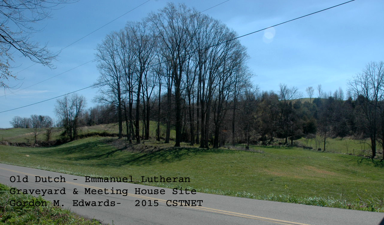
Old Dutch Meeting House Cemetery
2015
Also known as the Emmanuel Lutheran Church Cemetery.
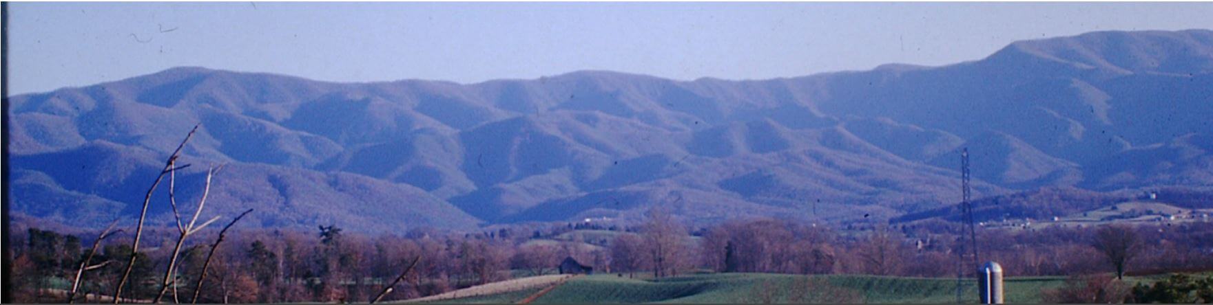
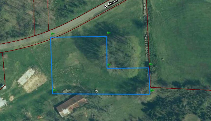
Located about two miles Southwest of Cherokee Baptist Church, Washington County, Tennessee on B. Chase Road, near the western end. It is between the headwaters of Booth Branch and Lloyd Branch. There are many unmarked graves and many marked by field stones. In recent years upkeep has improved, provided unofficially by concerned individuals
GPS Location 36°13.31N 082°29.41W; Elevation: 1683 ft.
| NAME | BIRTH DATE | DEATH DATE | COMMENTS |
|---|---|---|---|
| J. C. | J. C. 23 1860 [This may be John Cretselious 1823-1860] |
||
| S. N. C. | 1864 | ||
| May, Mary | 18 Feb 1832 | [Buried beside her husband, Cassimore May; maiden name - Horne] | |
| May, Cassimore | 1752 [May 4, 1752] | 1836 | PVT PA Line Rev War [Born in Germany; served 1777-1778 in the Rev. War] |
| Critselous, Elizabeth | 21 Jul 1817 | 03 Oct 1900 | |
| Critselous, Mary Ann | 08 Mar 1810 | Mar 1888 | Wife of Peter Walters |
| Kyker, Betty Rose | 1941 | 2022 | |
| Walters, Daughter | 30 Jan 1895 | 19 Feb 1895 | Daughter of John and Mary E. Walters |
| Walters, Linda Magelena | 17 Jul 1897 | 30 Sep 1900 | |
| Walters, Susan | 25 Sep 1838 | 27 Feb 1907 | |
| Walters, John | 29 May 1836 | 14 Aug 1907 |
Surveyed, transcribed and donated to the Washington County TNGen Web 2003 by Donna Cox Briggs and Betty Jane Hylton, researched by Gordon M. Edwards, members of the Cemetery Survey Team of Northeast Tennessee.
Copyrighted 2015 by the Cemetery Survey Team of Northeast Tennessee. No part may be copied without written permission from the Cemetery Survey Team.
Additional information
In the early 1960’s, John Frank Walters supplied the following names of those buried in unmarked graves:
Rudolph Cretselious husband of Elizabeth Cretselious
Samuel Keplinger, and wife Catherine Keplinger
Jacob Keplinger and wife, Mary Buzzard Keplinger
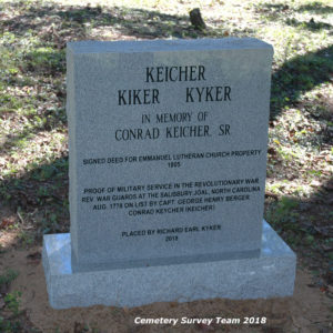
Conrad Kicher, along with others in the Kicher plot
Joseph Shannon and wife, Elizabeth Keplinger Shannon
David May and wife, Margaret Walters May
Mrs. Mary Hardin McCown surveyed this cemetery with John Frank Walters in October 1955. The following unmarked graves were identified.
Cretselious, Unknown
Cretselious, Rudolph, the pioneer of the Cretselious family
d. 1864
Freeman Family are buried in the southeast corner in unmarked graves
Keplinger, Catherine May, wife of Samuel Keplinger
Keplinger, Jacob, the immigrant to Tennessee
Keplinger, Mary Buzzard, wife of Jacob Keplinger
Keplinger, Samuel
Kicker, Unknown
Kicker, Conrad
May, Brothers [Two brothers were killed by the Rebels during the Civil War.]
May, David, son of Cassimore May, b. 3 May 1803
May, Margaret Walters, wife of David May
May, Mary Horne, wife of Cassimore May d. 13 Feb 1832
Shannon, Elizabeth Keplinger, wife of Joseph Shannon. Elizabeth K. Shannon and Joseph Shannon are buried near the north side fence.
[In 1955, twin white oak trees stood in the center of the Shannon graves.]
Shannon, Joseph
Walters, Linda Maglena, b. 17 Jul 1899, d. 30 Sep 1900
Richard Earl Kyker has placed a memorial marker in the cemetery for the Conrad Keicher, Sr. Family.
Conrad Keicher, Sr. Family
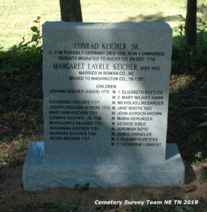
Conrad Keicker, Sr. Children
Washington County, Tennessee Deeds:
The first Washington County deed conveyance that can be positively identified is Deed Book 11, Page 234 – Joseph & Elijah Shannon to Jacob Keplinger (in 1807) for 180 acres. Plotting of the metes and bounds of this deed can be clearly overlayed onto the current tax map and clearly encompasses the area where the burial ground lays. This deed is silent on any meeting house or burial ground.
In August 1816, Jacob Keplinger conveyed (Deed Book 15, Page 175) 1 acre and 140 poles to the “New Lutheran Meeting House”. This small parcel was cut out of a survey done in April 1816, which laid out said parcel of 1 acre, 3 rods, and 20 poles (1 rod equals 40 poles of acreage) which included a meeting house. Prior succession called out in this deed shows the total acreage conveyed from Reuben Bayless, to John Keel, Keel to the Shannons, and the Shannons to Keplinger. Utilizing the succession enumerated in DB15/175 (viz Bayless to Keel to Shannon), prior deeds were able to be determined. A total of 4 deeds conveyed 2 parcels (which made up the 180 acres). These are Bayless to Keel (Deed Book 11, Page 261 in 1788 for the western 100 acres and Deed Book 7, Page 217 in 1795 for the eastern 80 acres) and Keel to the Shannons (Deed Book 6, Page 82 in 1796 for the western 100 acres and Deed Book 6, Page 83 in 1796 for the eastern 80 acres). This would seem to establish that the meeting house was constructed between 1807 and 1816. This deed, DB15/175, also calls for services to be conducted in German.
Deeds found for conveyance to Reuben Bayless are Deed Book 2, Page 92 (NC Grant #542 to Bayless) for the western parcel and Deed Book 7, Page 76 (Agnes Hammer as estate of John Fain Grant #330 to Bayless) for the eastern parcel.
The connection between Jacob Keplinger and John Critselous is familial. One deed will be referenced here to establish the connection. A few others, with similar wording have been found, and there are rather certainly more that have not been found (conveying undivided interests). The important sentence from Deed Book 36, Page 489 (in 1857) is thus: “………..containing altogether one hundred eighty acres, be the same more or less, and which said land was originally willed by Jacob Keplinger to Susan Critselous, wife of John Critselous, during her lifetime, and then to her children and their heirs…………”. Susan Critselous was the daughter of Jacob Keplinger.
The next pertinent deed was conveyance Deed Book 73, Page 451 (1897), in which the heirs of John Critselous (viz Jacob Critselous et al) convey to the Methodist Episcopal Church Trustees and successors a small parcel with an “old church house”. Named as said Trustees were George W. May, Robert Loyd, and William Swingle. This parcel was 210’ X 375’ in size. No mention of a graveyard was made. No further deeds have been found with respect to this parcel, in particular. Future deeds adjacent and wrapping around this land except it from conveyance.
The next deeds that are pertinent are conveyances from the heirs of Jacob Critselous to C. & R. Booth for the southern side (Deed Book 82, Page 452) of 37+ acres and to John & Susan Walters for the northern side (Deed Book 82, Page 21) of 57+ acres. Both of these deeds conveyed in 1902 and both excepted the graveyard. The metes & bounds clearly note the 210’ X 375’ parcel between the northern and southern parcels. The northern parcel (DB82/21) provided for a right of way from the public road (now B. Chase Road) to said graveyard. It is interesting to note that when the 210’ X 375’ parcel was conveyed (DB73/451) that it specified “church house” and in the other two deeds (DB82/21 & DB82/452) the term graveyard was used. Does this imply that the church structure was torn down between 1897 and 1902? Interesting to note, also, is that around this same time frame, the Vincent Methodist Church was established. It also implies that both the church house and the graveyard were within that 210’ X 375’ area.
Deeds have been found to account for the meeting house portion and the graveyard portion. DB73/451 covers the entire 210′ X 375′ parcel. This conveyance, as noted above, was from the Critselous heirs to the Methodist Episcopal Church Trustees. The meeting house portion was conveyed by the M.E. Trustees (now called the Trustees of the Vincent Church) to Deaderick & Brown in 1900 (Deed Book 134, Page 257), then by Deaderick & Brown to Samuel Coffee in 1902 (Deed Book 134, Page 258), and finally, Samuel Coffee to W. D. Walters in 1918 (Deed Book 134, Page 259). It is interesting to note that all three of the above mentioned deeds were not recorded until 1918. Those three deeds except the northeastern corner (115′ X 166′) which is the graveyard. This seems to indicate that the current owner of the Old Dutch Graveyard would be “Trustees of Vincent Church”.
The next pertinent deed found is Deed Book 165, Page 283 (1924). This is a partition deed dividing the farm of John Walters. The portion of about 46 acres that conveyed to W. D. (William D) Walters clearly included the graveyard area.
All deeds forward from the partition to present clearly except the graveyard. During the succession from 1924 to present, new surveys were done occasionally, with a plat being recorded in 1953 (Plat Book 3, Page 27), however the metes & bounds did remain substantially the same.
Old Dutch Meeting House Deed
The Archives of Appalachia, East Tennessee State University, Johnson City, Tennessee has some pages from the church records.