Broyles (John Jackson)
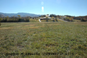
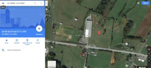
View is Approximate Location
This burial ground was identified during a deed review. During interviews, a few folks recalled hearing about a graveyard “up there on the hill somewhere”. A physical walkdown yielded no results, primarily due to the apparent grading and leveling of land in the approximate area. Due to some inaccuracy in survey data from many years ago, and the fact the survey only mentions a call ending at “east of graveyard”, an exact location has not been determined. It is also unknown if grading disturbed the grave(s), however, the grading does not appear to have been sufficient to reach grave depths.
The graveyard has been assigned the name John Jackson Broyles due to the fact that the deed in which he took title to the land was quiet on the existence of a graveyard and the partition of his property after his death did include mention.
No further information has been found at this time.
LOCATION – On or about Washington County tax parcel located on the north side of Highway 107 near the intersection of Pepper Mill Road in the South Central community.
Broyles (John Jackson)
GPS: Very approximate only: – 36.158565, -82.619835
DEEDS –
Deed Book 27, Page 121 (1845) – Michael Copp to Jack (John Jackson) Broyles – 130 acres. Quiet on graveyard.
Deed Book 69, Page 341 (1893) – M. W. Broyles to Simeon & Salina Broyles – Mentions a call ending at “…..on top of the hill east of the graveyard.” This is the “western” portion of the Jackie Broyles partition.
Deed Book 89, Page 105 (1905) – Ira Broyles to P. W. (Patton) Broyles – 73-1/2 acres. Mentions a call ending at “…..on top of the hill east of the graveyard.” The survey used in that deed has carried forward to present. This is the “eastern” portion of the Jackie Broyles partition.
Deed Book 157, Page 369 (1920) – Salina Broyles to J. R. Dunbar. This 6-3/4 acre parcel is the eastern section of the tract conveyed in DB 69, Page 341. Although this deed is quiet on the graveyard, it does include the property where the graveyard is most likely situated.
Adjacent property deeds have been reviewed and no further mention or reservation of the graveyard has been found.
BURIALS – Unknown
Researched and donated to the Washington County TNGen Web November 2016 by Gordon M. Edwards, member of the Cemetery Survey Team of Northeast Tennessee.
Copyrighted 2016 by the Cemetery Survey Team of Northeast Tennessee. No part of this work may be copied without written permission from the Cemetery Survey Team.