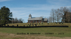
Providence Presbyterian Church Cemetery
2016
Washington County, Tennessee Tombstone Inscriptions by Charles M. Bennett and the Watauga Association of Genealogists. Information used with the permission of Lorraine Bennett Rae.
From volume 3, page 315 – entry 148
“Providence Presbyterian Church, located Route 1 Limestone on the Washington-Greene County line, is the second oldest church in Washington County. It was organized in 1780 by the Rev Samuel Doak. On Aug. 21, 1783, the Rev Sam Houston was ordained—the first Presbyterian minister to be ordained in Tennessee. Land records show that the Rev. Houston owned land in front of the church. He married a Miss Hall, who died a few months after their marriage and was buried on his land as shown by the deed. In 1795 HOUSTON married Margaret, daughter of Joseph Walker. Later he returned to Virginia where he pastored churches for more than 40 years—1791 until the 1830’s. he died Jan 20, 1839, aged 81, and is buried in High Bridge Cemetery. Copied April 3, 1958 by Charles M. Bennett. Notes from the files of CMB and from Irma Bowman Kitzmiller.”
This burial ground is being maintained very well and is managed by an association.
LOCATION – 2165 Happy Valley Road, Greene County, TN
GPS LOCATION: +36° 17.785, -82° 38.395
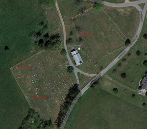
BURIALS – This cemetery is divided into two areas –
The old area is north of the church building and surrounded by a limestone rock wall. This area is no longer active, appears nearly full, and has been divided into several smaller sections for surveying purposes. Only graves with markers have been recorded. See aerial map for breakdown of sections. Row numbers go south to north (away from the church building) and grave numbers go east to west within each section.
The new area is south of the church building and surrounded by a chain link fence. This area is still active for burials. It has been divided into two sections for survey purposes – east/left of the driveway is labeled Section L and west/right of the driveway is labeled as Section R. Rows go north to south (away from the church building) and grave numbers go from the driveway outward. Rows were given alpha indicators to match cemetery records. On the east/left side, a short row is found between rows H and I. This row is noted as HS in cemetery records and this survey. The cemetery association has a good mapping of the new area, so the grave numbering coincides with that map. This presents survey numbers being skipped for graves that have not been used yet.
A handful of markers recorded in the survey from 1958 were not found. These have been included and are labeled as CNL (cannot locate) in the Row column. Other older markers have deteriorated since the 1958 survey and bits of information may no longer be legible, however, as long as the marker could be identified, all the data was included in this survey.
Old area
NAME BIRTH DEATH SEC/R GRAVE COMMENTS
Armstrong, Martha 30 Mar 1830 28 May 1872 CNL Wife of John Armstrong.
Carson, M[oses] 02 Mar 1757 23 Jul 1821 CNL From Prior Survey
Carson, Mary Campbell [No date] 20 Aug 1871 CNL Wife of Moses Carson
Million, Elbert Martin 12 ??? 1852 11 Jul 1858 CNL From Prior Survey
Moody, Levisa 06 Jan 1864 26 May 1867 CNL From Prior Survey
Thompson, Rachel Jane 03 Jan 1840 10 Aug 1844 CNL
Unknown, Elizabeth CNL Possible Sarah Gillespie - From Prior Survey
Loyd, John R. 07 Jan 1841 17 Jul 1861 A1 1 Son of Charles & Margaret Loyd
Loyd, Jacob 14 Sep 1838 17 Aug 1861 A1 2
Davault, Amanda Jane 25 Dec 1821 18 Dec 1865 A1 3 Wife of John Davault
C, H. A. A1 4 Possible Hetty Campbell Foot
Duncan, Joseph, Sr. 06 Jan 1788 10 Jul 1860 A1 5
Duncan, Molly 24 Jul 1787 28 Jan 1857 A1 6 Wife of Joseph Duncan, Sr.
Thompson, Robert 10 Aug 1830 10/07/43 A1 7
T, R. A. A1 8 Possible Robt A Thompson Foot
Unknown (illegible) A2 1 Possible Sarah Sims Gillespie
Gillespie, Allen 26 Jul 1769 19 Aug 1849 A2 2 Son of George Gillespie, Sr.
Ferguson, Martha J. 11 Aug 1851 04 Jun 1871 A2 3
Unknown (illegible) A2 4
Duncan, John R. 07 Aug 1830 A2 5 5 yrs. 6 mos. 23 days
Unknown (illegible) A2 6 Large H & S Marker
Unknown (illegible) A2 7 H & S Marker
Unknown (illegible) A2 8 Blank Foot Style Marker
Duncan, David T. 28 May 1819 08 Jun 1836 A2 9
Hays, Elizabeth 03 May 1852 09 Sep 1863 A3 1
Cowan, Florence Jane 11 Dec 1859 28 Aug 1863 A3 2
Hays, Nancy M. 10 Feb 1859 09 Feb 1863 A3 3
Hays, Anna E. 13 Aug 1821 03 Nov 1866 A3 4
Hays, John 19 May 1870 22 Jul 1871 A3 5 Top of Marker Missing
Hays, Margaret T. 01 Jul 1840 04 Oct 1869 A3 6 Top of Marker Missing
Hays, James T. 12 Sep 1867 03 Jul 1868 A3 7 Top of Marker Missing
Unknown (illegible) A3 8 Stub only
Unknown (illegible) A3 9 Stub only
Cosson, John 1750 1818 A3 10 Revolutionary War Soldier
Cosson, William 1744 1818 A3 11 Revolutionary War Soldier
Kennedy, Eli 16 Jan 1836 [No date] A3 12 Infant
Kennedy, Joseph C. 1800 13 Jan 1881 A3 13 Old Marker - 51 years old
Kennedy, Ann Allison 01 Feb 1790 19 May 1856 A3 14 Wife of David Thompson & Joseph C. Kennedy
Unknown (illegible) A3 15
Unknown (illegible) A3 16
Thompson, Eliza Hannah [No date] [No date] A3 17 Consort of B.A. Thompson.
Thompson, Louisa G. 19 Jan 1818 18 Jul 1887 A3 18 Widow of Robt A. Thompson.
Thompson, Robert A. 01 Jul 1810 20 Sep 1867 A3 19
Kennedy, Samuel R. [No date] ca. 1865 A3 20 CSA VET
Mercer, Rachel Thompson 11 Nov 1808 07 Dec 1838 A4 1 Wife of E. F. Mercer
Thompson, Joseph C. 01 Jan 1832 22 Mar 1887 A4 2
Stuart, Elizabeth Burk Thompson 29 Aug 1811 12 Feb 1837 A4 3 Wife of David Stuart
Seehorn, Sarah Jane 27 Sep 1829 13 Jul 1869 B1 1 Wife of James G. Seehorn
Campbell, Mary S. Morrow 12 Dec 1822 28 May 1906 B2 1 Wife of Brookins Campbell
Campbell, Hetty Alice 05 Oct 1853 06 Aug 1863 B2 2 Daughter of Brookins & Mary S. Campbell
Campbell, Brookins "Hon." 28 Jan 1804 25 Dec 1853 B2 3 Died while member of the 33rd Congress, Washington,D.C.
Morrow, Drury 28 Jul 1797 14 Dec 1870 B3 1
Kitzmiller, Sarah J. Morrow 16 Oct 1834 18 Apr 1863 B3 2 Wife of G.W. Kitzmiller
Morrow, Hetty 15 Jan 1802 20 Mar 1859 B3 3 Wife of Drury Morrow
Campbell, James 24 Mar 1806 28 Apr 1866 B3 4
Campbell, Susan 28 May 1823 12 Feb 1902 B3 5
Campbell, Hugh 01 Dec 1857 04 Jun 1862 B3 6
Carson, Lemuel 11 Aug 1781 06 Feb 1849 C1 1 War 1812
Carson, Sarah Ann Ross 27 Aug 1787 24 Aug 1867 C1 2 Wife of Lemuel Carson
Carson, Moses W. 22 Sep 1783 21 Jul 1852 C1 3
Carson, Margaret [Ross] 10 Oct 1794 11 Feb 1875 C1 4 Wife of Moses W. Carson
Brabson, John M., Sr. [No date] 14 Sep 1847 C2 1 Age 49 yrs. 9 mos. 21 days
Brabson, Mary E. 25 Apr 1816 27 Dec 1906 C2 2 Wife of Alfred B. Brabson
Brabson, Alfred B. 10 May 1811 14 Sep 1882 C2 3
Brabson, M.C. [No date] C2 4 Age 10
Brabson, Mary L. [No date] C2 5 Age 2
Brabson, George R. [No date] C2 6 Age 2 months
Million, Cordelia Ellender 11 Dec 1871 10 Jul 1872 D1 1
Million, Hannah Eliza 08 Jul 1862 08 Jul 1862 D1 2 Daughter of James & Elender Million
Million, James 29 Aug 1826 31 May 1864 D1 3
Million, Elender [Ellender] 06 Feb 1826 16 Oct 1864 D1 4 Consort of James Million
Blair, Sarah Ann 25 Nov 1815 06 May 1887 D1 5
Blair, Louiza M. 02 Sep 1820 08 Mar 1890 D1 6
Blair, John B. 1792 09 Apr 1876 D1 7 Age 84 yrs. War of 1812.
Blair, Levisa Shields 11 Oct 1794 18 Feb 1886 D1 8 Wife of John B. Blair
Unknown (illegible) D1 9 Base with stub only
Blair, John 11 Jul 1836 27 Jul 1867 D1 10
Blair, Mary I. 17 Jul 1836 10 Sep 1863 D1 11 Wife of John Blair.
Moody, Louisa 29 Jul 1829 07 Mar 1871 D1 12 Wife of B.F. Moody
Vance, Rachel Shelcy 07 Jun 1862 07 Jun 1862 D1 13
Unknown (illegible) E1 1 H & S Marker
Bashor, Susan E. 19 Mar 1868 16 Sep 1869 E1 2 Daughter of B.F. & Julia Bashor.
Taylor, Robert 19 Oct 1793 05 Oct 1871 E1 3
Taylor, Nancy 11 Dec 1805 18 Feb 1856 E1 4 Wife of Robert Taylor
Morelock, John F. 17 Mar 1857 25 Jun 1863 E1 5 Son of Sarah A. & Geo. W. Morelock
Morelock, Sarah A. 03 Dec 1830 15 Nov 1876 E1 6 Wife of Geo. W. Morelock
Morrow, Rebecca J. Carson 03 Dec 1830 03 Jan 1871 E1 7 Wife of J.H. Morrow
Morrow, James Hagan 14 Apr 1837 08 Apr 1902 E1 8
Moore, Lutissa S. 24 May 1823 26 Jan 1865 E1 9 Wife of James Moore
Moore, Margaret C. 25 Dec 1857 18 Jul 1864 E1 10
Carson, Moses 23 Aug 1813 26 Jun 1866 E1 11
Carson, Sara Jane 26 Dec 184? 24 Aug 184? E1 12 Daughter of Moses & Mary Carson
Humphreys, Delilah J. 16 Oct 1806 29 Aug 1873 E1 13 Wife of Wm. Humphreys
Humphreys, Wm. 19 Sep 1809 19 Jul 1866 E1 14
McCall, Pertheny 11 Oct 1790 01 Apr 1854 E1 15 Wife of William McCall
Unknown (illegible) E1 16 Possible Wm McCall [Prior Survey]
Tadlock, Mary J.B.T. 21 Dec 1829 26 Oct 1862 F1 1
Tadlock, Sevier 10 Mar 1801 06 Dec 1882 F1 2
Tadlock, Mary B. 19 Nov 1799 11 Aug 1879 F1 3 Wife of Sevier Tadlock
Tadlock, Sevier Newton 12 Oct 1833 01 Mar 1853 F1 4
Gillespie, George H. 24 Sep 1789 20 Aug 1846 G1 1 Son of John, the Son of George Gillespie, Sr.
Gillespie, Nancy Ann Ross 27 Aug 1787 03 Aug 1854 G1 2 Consort of George H. Gillespie. Daughter of Ed Ross
Cremer, Thomas 20 Sep 1800 27 Apr 1853 G1 3
Cremer, 05 Apr 1833 10 May 1854 G1 4
Stonecifer, Maj. Absalom 25 Nov 1808 03 Feb 1879 G1 5
Stonecifer, Barbary Jane Gillespie 27 Jul 1818 13 Apr 1851 G1 6 Daughter of Geo. H. Gillespie and consort of Absalom Stonecifer
Buchanan, Matilda [No date] 09 Jun 1858 G1 7 Age 39 yrs. 3 mos. 11 days Wife of Hervey Buchanan.
Buchanan, Laura Lucinda 05 Jun 1855 03 Aug 1864 G1 8
Buchanan, Martha Atwood 04 Nov 1844 07 Aug 1864 G1 9
Buchanan, Hervey [No date] 16 Dec 1860 G1 10 Age 51 yrs. 11 mos. 4 days
Martin, 07 Mar 1861 G2 1
Martin, [No date] G2 2
Martin, George W. G2 3
Martin, Joseph M. 19 Jan 1837 28 Dec 1877 G2 4
Martin, Deborah 05 Jul 1863 G2 5
Martin, G[regory] G. 01 Jan 1848 17 Nov 1864 G2 6 Killed at Bulls Gap (Civil War) Co. 1 8th Tenn. Cav.
Martin, Deborah [Register] 05 Apr 1817 31 Jan 1882 G2 7 Wife of Lewis T. Martin
Martin, Lewis T. 19 May 1814 03 May 1863 G2 8
King, Thomas 14 Mar 1833 17 Jul 1909 G2 9
King, M.A. 14 Sep 1845 09 Jan 1869 G2 10 Wife of Thomas King
Armstrong, Rebecca Ann 17 Jan 1841 02 Apr 1862 G2 11 Wife of John Armstrong.
Armstrong, Maryl A. 10 Nov 1858 13 Sep 1877 G2 12
Armstrong, John 30 Mar 1837 04 Jul 1866 G2 13
Hays, Charles 1800 1874 G3 1
Hays, Elizabeth 1804 1873 G3 2 Wife of Charles Hays
Unknown (illegible) G3 3
Aston, Emma 01/13/58 07/14/79 G3 4 Wife of S. P. Aston.
Blakely, Charity 12/02/19 07/07/85 G3 5 Wife of Mathew S. Blakely.
Blakely, Mathew S. 01/02/18 05/02/78 G3 6
Jones, Worley E. 04/11/43 05/10/73 G3 7
Harrison, Thomas F. 06/07/31 10/05/59 G3 8
Harrison, Martha Jane 08/28/25 04/25/61 G3 9
New area
NAME BIRTH DEATH SEC R/G COMMENTS
Good, Eva S. 1868 1884 L A01
Campbell, Fadilla 21 Feb 1824 18 Jun 1888 L A02
Broderick, Louvisa A. 17 Aug 1835 19 Jul 1910 L A10
Broderick, Samuel L. 18 Jun 1825 09 Feb 1883 L A11
Broderick, John B. 06 Oct 1863 19 Mar 1902 L A12
Broderick, Charles 1867 1935 L A13
Carson, Elizabeth 01 Aug 1807 06 Oct 1889 L A14
Carson, Mary E. 24 Apr 1850 22 Oct 1934 L A17
Carson, Franklin B. 03 Aug 1848 13 Jun 1919 L A18
Carson, Ferba 23 Mar 1893 12 Oct 1894 L A19 Shares headstone with Myrtle & Arthur
Carson, Myrtle 29 Oct 1887 16 Aug 1890 L A20 Shares headstone with Ferba & Arthur
Carson, Arthur 10 Apr 1886 03 May 1886 L A21 Shares headstone with Myrtle & Ferba
Carson, Thelma R. Phillips 16 Jan 1912 01 Mar 1957 L A22
Carson, Carl Franklin 16 Apr 1890 29 Apr 1966 L A23
Armentrout, Mollie F. 1887 1970 L B01
Armentrout, Joe H. 28 Feb 1884 12 Feb 1917 L B02
Armentrout, Denver Hollis 02 Apr 1899 02 Feb 1911 L B03 Son of R.E. and Maggie Armentrout.
Armentrout, Martha J. 1836 1910 L B04
Armentrout, Cora E. 15 Jan 1870 16 May 1910 L B05
Armentrout, Richard 20 Nov 1831 18 Apr 1898 L B06
Armentrout, Eliza 13 Oct 1844 22 Aug 1898 L B07
Humphreys, David 05 Jan 1848 17 Jun 1883 L B08
Bails, Jane 12 Feb 1804 17 Jun 1883 L B09
Carson, Julia A.V. Miller 02 Dec 1848 12 Nov 1933 L B13
Carson, John Ross 03 May 1826 09 Dec 1912 L B14 CSA Veteran
Carson, Charlie 17 Dec 1879 10 Dec 1890 L B15
Carson, Infant son 31 Oct 1912 31 Oct 1912 L B16 Son of C.B. and Ada Carson
Carson, Ada Lewis 02 Mar 1892 03 Sep 1962 L B17
Carson, Courtney B. 22 Apr 1875 07 Nov 1943 L B18
Carson, John Ross 07 Mar 1914 22 Oct 2002 L B19
Carson, Joseph S. 1974 1974 L B20 WW II Veteran
Carson, Minnie W. 1914 2003 L B21
Carson, Carolyn Patton 01 Nov 1924 19 Feb 2013 L B22
Carson, James Fred 18 Dec 1922 04 Jun 2006 L B23
Miller, Maude L. 05 Oct 1873 25 Jun 1933 L C01
Miller, Fannie McClendon 1849 1907 L C02 Civil War Veteran (Union)
Miller, John Noel 1844 1911 L C03
Miller, Greeneberry 21 Oct 1812 25 Feb 1896 L C04
Morelock, Louisa 1838 1900 L C15
Morelock, George W. 1833 1900 L C16
O'Keffe, Henry 05 Aug 1892 22 Sep 1892 L C22 Infant son of Arthur and Grace Million
Gourley, Ida M. 04 Sep 1840 01 May 1891 L D01 Wife of C.M. Gourley.
Gourley, Alfred T. 13 Oct 1857 01 May 1923 L D02
Gourley, Margaret E. 21 Sep 1856 23 Jul 1934 L D03
Gourley, Charles T. 02 Apr 1898 23 Apr 1966 L D04 WW I Veteran
Gourley, Maggie M. 1896 1981 L D05
Gourley, Etheridge R. 22 Nov 1926 08 Nov 1995 L D06 Son of Maggie
Gourley, Pauline 1848 1995 L D07
Gourley, Joseph Wallace 1893 1898 L D08 Son of A T & Margaret
Kite, H.L. 27 Aug 1874 23 Oct 1893 L D09
Gourley, Maggie Austin 13 Aug 1896 16 Aug 1977 L D10
Gouley, Alfred Rader 02 Mar 1895 18 Apr 1968 L D11 Husband of Maggie A.
Gourley, Margaret Mae 03 Jan 1925 18 Oct 1929 L D12 Daughter of A.R. and Maggie Gourley.
Morelock, Malissa Brodick [31 Jan]1859 [23 Dec]1944 L D15
Morelock, Nathan Alexander [11 Jul]1853 [02 Nov]1933 L D16
Morelock, Glenna Pearl 1893 1992 L D17
Jones, Ida 1873 1950 L D25
Jones, William 1880 1955 L D26
Seehorn, Brucie 20 Jun 1884 31 Jul 1893 L E01 Son of B.C. and E.C. Seehorn
Carson, Susan M. 1883 1966 L E03
Carson, Hugh W. 1882 1968 L E04
Carson, Clive W. 23 Feb 1917 27 Nov 1976 L E05 WW II Veteran
Carson, Herbert C[arl] 15 Nov 1920 31 May 2003 L E06
Prichette, Molly 1875 [12/1/1940] L E10
Campbell, Infant son 26 Apr 1898 26 Sep 1902 L E11
Campbell, Dora E. 1870 1953 L E13
Campbell, Matthew B. 1853 1926 L E14
Campbell, Fred C. 06 Aug 1896 02 Apr 1978 L E15
Campbell, Thelma M. 23 Oct 1898 01 Dec 1979 L E16
Broyles, Laird L. 1943 1960 L E17
Broyles, Helen 1925 1960 L E18
Broyles Marvin Clifton 1920 1990 L E19
Broyles Nola [No date] [No date] L E20
Campbell, Mildred C. 18 Sep 1927 09 Jan 1984 L E21
Campbell, Earl L. 19 Jul 1927 22 Aug 2013 L E22
Gourley, James F. 05/?/1941 28 Nov 1989 L F06 Son of A R & Maggie
Gourley, Flora Mae 1915 1974 L F11 Wife of Sam A.
Gourley, Samuel A. 30 Mar 1915 1973 L F12
Jaynes, Linda Sue 02 Sep 1945 24 Aug 2015 L F13
Blakely, Joel 4/?/1852 11/?/1919 L G09 Marker Located Here
Ferguson, John H. 03 May 1863 03 Dec 1895 L G12
Ferguson, Drucilla Blakely 1838 1/31/1895 L G13 Wife of Henry Ferguson.
Austin, Donald Wayne 20 Aug 1947 20 Aug 1947 L G20
Austin, Ruth M. 1879 1946 L G21
Austin, J. Jackson 18 Feb 1876 13 Mar 1929 L G22
Austin, Samuel B. 1909 1909 L G23
Austin, Infant son 1903 1903 L G24
Martin, E.R. 27 Jun 1835 06 Nov 1918 L H01
Martin, Rachel 17 Nov 1841 01 May 1896 L H02
Unknown L H04
Martin, Hettie B. 1919 1919 L H05
Martin, Nellie Bright 14 Aug 1881 15 Jan 1919 L H06
Martin, Joe Mahoney 02 Jan 1866 06 Feb 1940 L H07
Martin, S.M. 07 Mar 1867 27 Jun 1918 L H08
Martin, Infant 1898 1898 L H09
Martin, T.F. 23 Apr 1856 11 Apr 1938 L H10 Died at Minneapolis, MN
Martin, Mary M. 08 May 1850 12 Oct 1918 L H11 On marker, not on plot record
Martin, W.C. 31 May 1850 01 Nov 1940 L H11
Martin, Joe S. 1872 1951 L H12
Keys, Robin Marie 19 Oct 1953 24 Jul 2004 L H13
Keys, Frank Baxter 26 Feb 1954 05 Jan 2010 L H14
Bailey, Nancy Taylor 04 Apr 1858 20 Jul 1907 L H19 Wife of George A. Bailey
Taylor, Lucinda 11 Feb 1826 08 Oct 1896 L H20 Wife of Robert Taylor
Martain, Infant 1945 1945 L H22 Son of Sam & Willie Martin
Martin, Willie R. 1926 [No date] L H23
Martin, Samuel M. 1916 1977 L H24
Williams, Alie Martin 05 Feb 1905 16 Jun 1987 L H25
Martin, Lena Moore 31 Jan 1876 07 May 1953 L H26
Martin, Grant 12 Jan 1869 08 Jul 1953 L H27
Martin, Franklin Claude 18 Sep 1908 12 Dec 1971 L H28
Martin, Sarah S. 22 Jun 1916 25 Jan 2008 L H29
Nelson, Mattie C. 11/15/1863 21 Nov 1927 L HS01
Nelson, Newton H. 1893 1966 L HS03
Nelson, Nola G. 1905 2000 L HS04
Martin, Joe F. 30 Sep 1929 17 Aug 2003 L HS05
Martin, Eleanor R. 07 Jun 1936 26 Nov 2005 L HS06
Nelson, Jackie P[aulette] 12 Aug 1967 12 Aug 1967 L HS07
Nelson, Stanley S. 09 May 1956 16 May 1970 L HS08
Nelson, Paul 27 Dec 1927 12 Aug 2009 L HS09
Nelson, Eva Rose 04 Feb 1931 L HS10
Shanks, Robert 23 Mar 1835 14 Apr 1898 L I01
Martin, Bertha E. 13 Aug 1865 13 Sep 1905 L I05
Martin, T.R. 23 Apr 1856 11 Apr 1938 L I06
Martin, Annie D. 06 Apr 1889 23 Sep 1973 L I07
Gregg, Brenda 19 Dec 1952 L I09
Gregg, David 18 Sep 1952 30 Mar 2005 L I10
Martin, Frank R. 21 Jan 1901 23 Aug 1933 L I12
Martin, James Yates 16 Dec 1910 07 Mar 1957 L I13
Martin, Dorothy K. 14 Aug 1915 18 Aug 1997 L I14
Martin, Albert F. 27 Oct 1908 14 Aug 1968 L I15 WW II Veteran
Stoots, Bertha M. 22 Sep 1916 24 Jan 2004 L I18
Stoots, Junior F. 19 Oct 1926 19 Oct 1926 L I19
Stoots, Rose 1908 1984 L I20
Stoots, William 1885 1938 L I21
Stoots, Mary 1900 1925 L I22
Stoots, Evelyn 24 Oct 1922 18 Feb 1923 L I23
Good, Homer 24 Sep 1934 09 May 2004 L I27
Good, Maude A. 1909 1982 L I28
Good, Stewart 1895 1975 L I29
Wheelock, Vadna F. 30 Oct 1937 18 Dec 1995 L I30
Wheelock, Carl K. 25 Sep 1930 2015 L I31
Dye, David Allen 24 Sep 1960 31 Mar 2011 L I32
Barlow, John R. 02 Apr 1893 05 Nov 1893 L J01
Reppond, Bernice Lois 30 Jan 1938 L J03
Kinley, Montie Wayne 10 Apr 1939 19 Jun 2012 L J04
Armstrong, Georgie B. 1887 1906 L J05
Armstrong, Deby Cochran 1860 1930 L J06
Armstrong, David J. 1857 1931 L J07
Kinley, Joy Ann 10 Jun 1940 22 Jul 1941 L J08 Dau of Sam T Kinley
Kinley, Edith C. 16 Jul 1913 18 May 1995 L J09 Wife of Sam T Kinley
Kinley, Sam T. 06 Apr 1912 19 Nov 1989 L J10
Gregg, Gladys M. 25 May 1926 17 Aug 1994 L J11
Gregg, George W. 22 Oct 1921 12 Oct 1985 L J12
Pates, Wilma Moles 25 Jun 1934 L J16
Moles, Callie M. 04 Mar 1913 31 Aug 2010 L J17
Moles, Wm. Harold 18 Apr 1909 12 Mar 1997 L J18
Moles, Wilson M. 02 Jan 1879 21 Oct 1957 L J19
Moles, Lottie McMackin 02 Jun 1887 11 Jun 1954 L J20
Moles, John T 27 Jan 1868 03 Jul 1913 L J21
Moles, Sabrina Boyd 15 Mar 1931 15 Jun 1907 L J22
Moles, A.J. 13 Mar 1830 11 Jun 1906 L J23
Fogerty, Tina 1968 2015 L J26
Keys, Eva Hazen 1924 1924 L K01
Million, S. Keith 19 Nov 1917 [No date] L K04
Million, Anna Mae 11 Jan 1934 [No date] L K05
Million, Georgia S. 16 May 1912 27 Nov 2006 L K06
Million, Robert L. 21 Jan 1912 23 Jan 1980 L K07
Baskette, Ruth Million 28 Apr 1913 29 Oct 2005 L K08
Baskette, Bert Taft 03 Oct 1909 02 May 1958 L K09
Baskette, Lula A. 1884 1979 L K10
Million, James M. 1876 1955 L K11
Million, Laura 02 Jan 1887 12 Jul 1957 L K12
Million, Clara M. 25 May 1883 28 Mar 1922 L K13
Million, Mahalia J. 28 May 1847 16 Jul 1928 L K14
Million, Arthur Robert 23 Feb 1848 20 Dec 1932 L K15
Million, Ida Ruth 19 Jun 1919 10 May 2007 L K16
Million, James David 04 Mar 1915 25 May 1992 L K17 WW II Veteran
Million, A. Terrance 18 Sep 1964 18 Sep 1964 L K18 Infant son of Arthur and Grace Million
Million, Arthur 27 Jan 1926 27 Oct 1991 L K19 WW II Veteran
Million, Grace E. Hice 31 Jul 1928 27 Oct 1998 L K20
Spraggins, Janice M. 1946 [No date] L K21
Spraggins, James Perry 1943 1980 L K22 Vietnam Veteran
Austin, Johnny 31 Jul 1912 31 Jul 1912 L K24
Austin, Wm. Byrd 02 May 1888 09 Jan 1976 L K25
Austin, Maude Alexander 10 Jun 1892 08 Apr 1983 L K26
Austin, Nina Sarah 1921 2012 L K27
Austin, Alberta L. 1909 2003 L K28
Austin, Charlotte L. 1833 [No date] L K30
Austin, Onnie 31 Jul 1912 05 Sep 1974 L K31 WW II Veteran
Willis, John Wesley 08 Jun 1924 29 Jun 1924 L L01 Son of James and Bessie Willis
Willis, Bessie Teasner 22 Sep 1893 02 Mar 1949 L L02
Willis, James 09 Feb 1881 13 Apr 1964 L L03
Unknown L L04 Possibly 2 Babies - Unmarked
Tilson, Alma Gouley 01 Jul 1918 29 Nov 1994 L L05
Murray, Larry 13 Nov 1942 27 Jul 2006 L L06
Murray, Infant 1937 1937 L L07 No Marker
Million, Jerry Lynn 29 Oct 1944 02 Jun 1988 L L10 Vietnam Veteran
Million, Rosa Lee 13 Sep 1921 26 Dec 2009 L L11
Million, Charles N. 10 May 1916 09 Dec 2002 L L12
Million, Elizabeth F. 1928 [No date] L L23
Million, Willis B. 02 May 1919 16 Sep 1996 L L24 WW II Veteran
Unknown L L26
Million, Patricia L. 21 Aug 1949 L L27
Million, Willis D[avid] 16 Jun 1950 17 Nov 2000 L L28
Austin, Martha Adams 1853 1925 L M01
Austin, John 1855 1925 L M02 WW II Veteran
Austin, Sally L. Townsend 20 Nov 1879 19 Aug 1970 L M03
Austin, Samuel H. 28 Feb 1874 07 Mar 1941 L M04
Austin, Ira Kenneth 09 May 1927 21 Feb 1966 L M05
Austin, Thelma E. 25 Sep 1925 25 Sep 1925 L M06
Austin, Kyle 28 May 1926 28 May 1926 L M07
Austin, William Western 23 Jan 1904 17 Jul 1976 L M08
Austin, Maude Morris 11 Dec 1903 11 Feb 1994 L M09
Austin, Maxie Faye 08 Aug 1932 [No date] L M10
Morris, Verge Alford 26 Nov 1871 20 Aug 1940 L M11 See also R-I21 Cemetery records support this location.
Morris, Lucy Bell 15 Mar 1880 08 Dec 1957 L M12
Campbell, Linda Ann 30 Jun 1960 02 Jul 1960 L M14
Campbell, Eva C. Austin 09 Apr 1929 12 Apr 1963 L M15
Campbell, Harlan L. 11 May 1924 [No date] L M16
Price, Frances Austin 21 May 1930 [No date] L M21
Price, Charles Howard 28 Jul 1924 06 Jun 1984 L M22 WW II Veteran
Austin, Fay Elizabeth 08 Dec 1926 22 Aug 1928 L N03 Infant of C.F. and Dimple Austin
Austin, Max Donald 14 Sep 1929 14 Sep 1929 L N04 Infant of C.F. and Dimple Austin
Austin, Jewel Ann 30 Mar 1938 20 Mar 1938 L N05 Infant of C.F. and Dimple Austin
Austin, John 23 Oct 1908 07 Sep 1931 L N08
Townsend, Malinda A. 10/291/892 31 Jan 1964 L N13 Wed 8/13/1911
Townsend, Azor V. 03 Nov 1883 20 Mar 1965 L N14 Wed 8/13/1911
Cochran, John B. 1862 1930 L O01
Cochran, Alice Good 1860 1950 L O02
Murray, James A. 02 Feb 1941 07 Mar 1941 L O06 Son of Windle Murray
Hassell, Ethalyn Rector 10 Nov 1927 L O20 Sister to Gladys & Letha
Booher, Gladys Rector 05 Nov 1919 02 Nov 1990 L O21 Sister to Ethalyn & Letha
Cole, Letha Rector 09 Mar 1917 27 Sep 2002 L O22 Sister to Ethalyn & Gladys Rector
Wolfe, Elizabeth 30 Oct 1858 20 Aug 1931 L O23
Rector, Iva Jerome 07 Jan 1922 25 Oct 1925 L O24
Rector, Jessie Pearl Wolfe 07 May 1886 10 Jul 1963 L O25
Rector, Richard Carter 01 Apr 1882 03 Feb 1954 L O26
Showman, Myrtle Rector 1909 [No date] L O27
Showman, George R. 1906 1964 L O28
Rector, Stephen K. 26 Sep 1951 17 Dec 1969 L O29
Rector, Lucy P. 18 Oct 1928 09 Sep 2004 L O30
Rector, James Jay 01 Nov 1924 23 Jun 1996 L O31 WW II Veteran
Rector, Larry Dale 18 Sep 1950 09 Nov 2007 L O32
Mitchell, Phyliss Rector 08 Dec 1948 L O33
Keys, Tanya Michelle 09 Aug 1975 09 Aug 1975 L O35 Dau Michael & Phyllis Keys
Showman, Florence C. 02 Oct 1905 01 Feb 1994 L O39
Showman, Benjamin H. 12 Apr 1892 03 Oct 1967 L O40 Veteran
Tarlton, James E. 1937 2002 L O46
Tarlton, Mary Showman 08 Jun 1917 26 Jun 1997 L O47
Tarlton, William 09 May 1942 27 Jun 1997 L O48
Shelton, Mary Emmaline 16 May 1878 02 Oct 1946 L P01
Hensley, Morstonie 07 Dec 1904 16 Apr 1974 L P02
Hensley, Hoy 06 Dec 1911 06 May 1987 L P03 Husband of Ada J Austin
Hensley, Ada J. Austin 28 Apr 1915 [No date] L P04 Dau Samuel & Sallie Austin
Hensley, Clara B. Shelton 1909 1980 L P23 Wife of Miles
Hensley, Miles J. 1900 1972 L P24 Son of Mary E
Hensley, Arthur Eugene 27 Apr 1934 02 May 1936 L P25 Son of Miles J. & Clara S.
Hensley, Chester 1935 1993 L P26 son of Miles J. & Clara S.
Hensley, Atlas Emmeline 05 Apr 1930 24 Aug 2005 L P27
Bales, Dorothy D. Fletcher 19 Feb 1921 10 Sep 1987 L P32
Bales, Leonard C. 15 Nov 1919 02 May 1987 L P33 WW II Veteran
Bales, Randy Wade 08 Mar 1956 01 Sep 1988 L P34
Bales, Thomas E. 23 Oct 1952 14 Oct 2007 L P36
Parker, Samuel E. 1934 1974 L Q01
Parker, Mamie 01 Sep 1905 14 Oct 1995 L Q02
Parker, George 18 Feb 1900 15 Jul 1997 L Q03
Hobbs, Robert 1900 1976 L Q04
Hobbs, Elizabeth 1904 1975 L Q05
Kerney, George Taylor 1929 2009 L Q06
Kerney, Rose Mary 1937 2000 L Q07
Kerney, Charles A. 01 Sep 1938 15 Apr 2007 L Q08
Nelson, Joseph Hardy 12 May 1933 31 Oct 1995 L Q09 Veteran
Nelson, Georgie E. 13 Mar 1936 L Q10
Nelson, Ora Mae 22 Feb 1910 28 Sep 1991 L Q11
Nelson, Henry C. 02 Aug 1904 16 Nov 1973 L Q12
Pleasant, Bessie Nelson 12 Jul 1943 22 Dec 1985 L Q13
Akins, Melissa Lynn 08 Jan 1973 29 Aug 2004 L Q44
Akins, Gloria Bradley 28 Feb 1949 L Q45
Akins, MacLellan 17 Jun 1949 21 Aug 2003 L Q46
Lewis, Eula Lee Ramsey 12 May 1929 21 Oct 1998 L Q47
Akins, Warren G. 26 Mar 1922 02 Jun 1990 L Q48 WW II Veteran
Morgan, Infant L Q49 Of Thos & Clara - Unmarked
Parker, Flossie 17 Jul 1936 10 Aug 2006 L R03
Parker, Artie 1932 1936 L R04
Sailers, Raymond 1950 2015 L R05
Akins, Mildred Millie 1939 2014 L R47
Cox, Billie E. 11 Sep 1955 30 Oct 2008 L S07
Cox, Minty 02 Feb 1934 06 Apr 2014 L S08
Cox, Bill J. 23 Jan 1930 19 Aug 2008 L S09
Harris, Pamela J. 08 Oct 1958 L S12
Harris, H. Trent 30 Aug 1953 07 Jul 2009 L S13
Harris, Louise Gourley 1923 1987 L S14 Dau of A R & Maggie A
Harris, Harry D. 28 Aug 1923 21 Aug 1983 L S15 WW II Veteran
Murray, Andy Kate 30 Oct 1920 27 Aug 2001 L S16
Murray, Keith Saylor 27 Feb 1919 L S17
Austin, Lonnie Clark 3/?/1940 3/?/1940 L S25
Austin, Lonnie 31 Jul 1912 19 Aug 1982 L S26
Austin, Grace W. 11 Mar 1922 10 Mar 2007 L S27
Jones, Richard Lee 01 Sep 1923 09 Mar 1977 L S28 WW II Veteran
VanDerMerwe, Catharina 24 Jul 1932 13 Oct 2012 L S36
VanDerMerwe, Johannes 25 Aug 1929 L S37
Gourley, Joye R. 17 Aug 1932 10 Mar 2002 L U06
Gourley, William R. 19 Oct 1931 L U07
Dobner, Jordan Ali 2013 2013 L U11
Mercer, Willie D. 29 Mar 1836 26 Sep 1888 R A01
Mercer, R.T. 29 Apr 1845 07 Dec 1898 R A02
Mercer, Martha A. 08 Feb 1851 25 Jan 1917 R A03 Wife of R.T. Mercer
Hall, Frank R A04 No Marker
Unknown R A15
Unknown R A16
Gibson, russell 07 Nov 1890 10 Jan 1895 R A17
Unknown R A18
Unknown R A19
Keys, Oscar L. 07 Nov 1878 30 Dec 1889 R B01 Son of E.L. Keys
Keys, Luverna 14 Nov 1907 08 Jun 1908 R B02
Keys, Bessie 13 Oct 1880 01 Sep 1910 R B03
Keys, John 1855 1915 R B04
Keys, Lanore E. 1856 1923 R B05
Nelson, Johnny 19 Mar 1920 19 Dec 1922 R B09 Son of F.M. and Ester Nelson
Nelson, Wm. 07 May 1926 07 Apr 1927 R B10 Son of F.M. and Ester Nelson
Adams, Sarah Virginia 1860 1920 R B17
Adams, Martha L. 1895 1896 R B18
Dickison, Graver [No date] [No date] R B19 34 yrs. old
Dickison, Martha [No date] 03 May 1888 R B20 67 yrs. old; wife of Wm. Dickison.
Blakely, Polly [No date] 24 Oct 1898 R B21 55 yrs. old; wife of J.E. Blakely.
Blakely, Joel 4/?/1850 11/?/1919 R B22 Cem Records but No Mkr
Gray, John [No date] ca 1884 R C01
Gray, Sophia [No date] ca 1884 R C02
Roberts, Thomas Homer 18 Jun 1896 [No date] R C12
Roberts, Minnie Waller 11 Nov 1901 29 Aug 1952 R C13
Roberts, Myrtle R C14 Unmarked
Roberts, Clara Sue R C15 Unmarked
Wallar, William Elbert 1850 1939 R C16
Wallar, Kate Elizabeth 1865 1934 R C17
Gibson, G. Dewey 09 May 1899 15 Jan 1917 R C20
Unknown R C21
Unknown R C22
Unknown R C23
Unknown R D01
Unknown R D02
Unknown R D03
Unknown R D04
Hall, Mary J. 1954 R D05 Grave unmarked.
Hall, James F. 1906 12 Feb 1991 R D06 Grave unmarked.
Hall, G.W. R D07 Grave unmarked.
Hall, Tom 15 Mar 1997 R D08 Grave unmarked.
Dayton, Wm. Earl 18 Oct 1943 18 Oct 1943 R D11
Dayton, Earl 01 May 1915 03 Jul 1943 R D12 Veteran
Carver, Rosa Waller-Dayton 1910 1995 R D13
Carver, Henry "Arlen" 26 Sep 1898 21 Aug 1985 R D14 Veteran
Gibson, Harrison 18 Jul 1888 27 Jan 1977 R D15 WW I Veteran
Gibson, Hannah Dickerson 15 Jun 1856 21 Jun 1936 R D16
Henry, G.W. 01 Nov 1848 06 Sep 1893 R D17
Horton, Martha R D18 Unmarked grave
Henry, Will 15 Jul 1885 14 Nov 1930 R D19
Horton, T.J. (Jim Tom) R D20 Unmarked grave
Adams, Mary E. 1871 1902 R E01
Adams, William B. 1861 1917 R E02
Adams, Clara Oviva 02 May 1894 27 Oct 1914 R E03
Foster, Evert [1910] [1911] R E04 Unmarked
Foster, Mary [29 Sep 1913] [5Jul 1914] R E05 Unmarked
Foster, Lennora B. 20 Aug 1891 16 May 1917 R E06 Wife of W.M. Foster.
Crawford, Evert 10 Sep 1910 27 Jul 1912 R E07 Son of J.F. and Oma Crawford
Crawford, Raymond 10 Mar 1909 13 Feb 1914 R E08 Son of J.F. and Oma Crawford
Crawford, Naoma Adams 1888 1926 R E09
Crawford, Frank Jr. 1888 1973 R E10
Crawford, Lena 1904 R E11
Crawford, Frank Jr. 1929 R E12
Foster, Ernest [1910] [9/x/1933] R E13 Unmarked grave; twin also died 1911.
Barnes, Myrtle Foster R E14 Infant Unmarked grave.
Foster, Marion 1882 1964 R E15
Foster, Trula 1898 1966 R E16
Steen, Lynn 5/191949 R E17
Steen, William Donald 17 Apr 1926 27 Mar 1952 R E18 WW II Veteran
Steen, Vernon V. 1897 1969 R E19 WW I Veteran
Steen, Ethel A. 1896 1970 R E20
Foster, Arthur "Lee" 1912 1972 R E23
Daughtery, Dewy J. 14 May 1899 31 Dec 1906 R E26 Son of A.J. and M.E. Daughtery
Pleasant, Jane 10 Jun 1850 27 Sep 1908 R F01
Pleasant, S.T. 27 Dec 1852 06 May 1909 R F02
Unknown R F03
Pleasant, William F. 18 Apr 1880 14 Feb 1948 R F04
Pleasant, Ethel W. 28 May 1884 03 May 1951 R F05
Pleasant, Orgil Melvin 18 Jan 1882 27 Apr 1954 R F06
Pleasant, Esther M. 07 Nov 1881 17 Nov 1960 R F07
Pleasant, Samuel R. 08 Sep 1909 21 May 1962 R F11 WW II Veteran
Pleasant, Sarah R F12 Unmarked
Gibson, Clarence E. 1893 1958 R F20
Gibson, Omega L. Parker 1900 1985 R F21
Blair, J. Shields 01 Dec 1828 03 Sep 1897 R G01
Blair, Amanda N. Keys 12 Aug 1853 16 May 1921 R G02 Wife of J.S. Blair & Frank Sellers.
Vance, John B. 10 May 1830 30 Dec 1905 R G03
Vance, Janie 16 Nov 1823 24 Jan 1901 R G04
Crawford, Phillip G. 24 Jul 1953 31 Jan 1954 R G09 Son of Roy and Ethelyn Cawford
Jones. G.W. 20 Jan 1841 05 Jun 1898 R H01 CSA Veteran
Jones, America Jane 01 Sep 1855 11 Nov 1946 R H02
Unknown R H03
Schilling, Charles C. 1869 1942 R H10
Schilling, Bettie Frye 1883 1971 R H11
Frye, Robert 1847 1902 R H12 CSA Veteran
Frye, Susan Wilcox 1849 1930 R H13
Frye, Josephine 13 Jun 1874 23 Nov 1884 R H14
Frye, Letty 1809 1883 R H15
Dickerson, Margaret 1827 1901 R H16
Dickerson, Joe 1825 1903 R H17
Campbell, John Mell 06 Apr 1876 03 Sep 1951 R I01
Campbell, Betty Izola 12 Aug 1912 12 Jul 1913 R I03
Campbell, George G. 01 Jan 1931 31 Aug 1950 R I04 Korean War Veteran
Campbell, Anna R. 05 Jun 1910 04 Jul 1982 R I05 Married 8-1-1925
Campbell, James G. 30 Apr 1907 19 Mar 1993 R I06 Married 8-1-1925
Nelson, Coy Rex 14 May 1930 02 Feb 2007 R I07
Nelson, Margaret Ann 18 Sep 1938 13 Aug 2010 R I08
Nelson, Joe R. 1905 1981 R I09
Nelson, Novella A. 1909 1990 R I10
Phillips, Edbert R. Jun-27 07 May 1994 R I11 Married 11/12/1955
Phillips, Ruby F. Nelson 26 Dec 1933 08 Nov 1992 R I12 Married 11/12/1955
Nelson, Roy Gene 11 Jun 1932 27 Oct 1982 R I16 Veteran
Nelson, Eula May [No date] [No date] R I17
Nelson, Kenya Jo 07 Feb 1979 29 Aug 2010 R I18
Nelson, Donald 04 Jul 1955 22 Jun 2003 R I19
Kinley, Whitney Lynn 09 Jan 1993 13 Sep 1996 R I20 Portrait on black granite.
Morris, Verge Alford [26 Nov]1871 [20 Aug]1940 R I21 Old style marker here - see also L-M11
Ball, Mellie [No date] [No date] R I26 Unidentified grave
Miller, Vernia R I27 Unidentified grave.
Hall, Frank R I28 Unidentified grave.
Hall, Annie Hall R I29 Frank Hall's sister; unknown if wed; no dates; unidentified grave.
Henderson, Mary S. 01 Jan 1898 03 Sep 1991 R J01 Urn is between Aaron & Nancy Keys.
Keys, Aaron, Jr 05 Jun 1938 17 Feb 1916 R J01 Civil War Veteran (Union)
Keys, Nancy Ann 25 Sep 1836 09 Jul 1920 R J02
Henderson, Mollie E. 26 Nov 1868 20 Dec 1948 R J04
Henderson, John T. 16 Aug 1862 03 Mar 1939 R J05
Million, Lucas James 06 Aug 1982 19 Dec 2001 R J08
Million, Justin Keith R J09
Million, Mary Ann 19 Jul 1966 27 May 2009 R J10
Taylor, Jimmy L. R J17
Taylor, Linda G. 08 Mar 1961 22 Sep 2006 R J18
Jeffers, E. McMillan 1850 1928 R K01
Jeffers, Elizabeth Sellers 1866 1922 R K02
Jeffers, Thomas 01 Jun 1892 26 Aug 1972 R K03
Jeffers, Ellen Austin 16 May 1911 22 Jun 1939 R K04 Wife of Thomas Jeffers
Jeffers, Judy Edith 16 Jan 1957 17 Jan 1957 R K10 Daughter of James and Edna Jeffers.
Jeffers, Roy 05 Jul 1890 19 Oct 1971 R K11 WWI Veteran
Jeffers, Addie 10 Nov 1902 09 Dec 1983 R K12 Wife of Roy Jeffers
Showman, W.S. 1861 1927 R L01
Showman, Nan 1872 1960 R L02
Showman, Johnny 1850 1929 R L03
Showman, Byrd W. 25 Jan 1885 01 Jul 1952 R L04
Guess, Nellie Showman 04 Jun 1913 26 Jan 1952 R L05
Showman, Charles H. 1909 1/6/1981 R L06
Showman, Scredula C. 1920 [No date] R L07
Showman, Luke Duke 19 May 1952 12 Sep 1995 R L08
Showman, Billy Jack 13 Jan 1943 06 Sep 2005 R L11
Showman, Jolene Lucas 20 Oct 1943 R L12
Showman, Jerry W. 08 Sep 1949 R L13
Showman, Vickie D. 13 Aug 1957 28 Feb 2001 R L14
Showman, John Roy 25 Jan 1938 02 Feb 2006 R L15 Air Force
Showman, Charles Howard 13 Jul 1939 29 Oct 2006 R L16 Air Force
Adams, Pernell 11 May 1963 24 Dec 2005 R L20
Montieth, Charles Boyd 09 Oct 1934 09 Oct 1934 R M01
Montieth, R. Blanch Presley 17 May 1915 19 Sep 1992 R M02
Montieth, Raymond Clifford 03 Dec 1914 24 Apr 1998 R M03
Presley, Sam B. 1917 2000 R M05
Presley, Bea A. 1920 1987 R M06
Presley, Glen T. 1900 1940 R M07
Presley, Robert B. 12 Jul 1872 27 Nov 1950 R M08
Presley, Annie Armentrout 30 Mar 1879 27 Feb 1965 R M09
Armentrout, Roy Elsworth 04 Dec 1874 12 Feb 1959 R M12
Armentrout, Maggie Alexander 02 Jan 1880 30 Oct 1965 R M13
Armentrout, Willis Pauline 10 Sep 1903 14 May 1989 R M14
Hall, Martha Irene 14 Oct 1909 11 Jul 2005 R M15
McAmis, R[obt] Willis 20 Mar 1930 30 Jan 2008 R M21 WWII
McAmis, Nina B. 20 Mar 1930 R M22
McAmis, James Timothy 01 Jul 1961 17 Mar 1998 R M23
Jordan, Thomas J. 01 May 1866 14 Mar 1943 R N01 Father of Raymond
Jordan, Marcena P. 12 Apr 1872 01 Oct 1965 R N02
Jordan, Raymond 14 Apr 1906 05 Jul 1993 R N03 Father of Clyde
Jordan, Beth 24 Apr 1906 03 Sep 1991 R N04
Jordan, Clyde T. 28 Mar 1927 09 Apr 2007 R N05
Jordan, Betty Lou 19 Jul 1930 04 Jan 2000 R N06
Fellers, Robert L. 17 Nov 1910 09 Aug 1977 R N08
Fellers, Maude Presley 30 Oct 1913 24 Apr 2006 R N09
Million, Samuel R. 12 Aug 1949 24 Jun 2010 R N16
Million, Patsy S. Jordan 04 Feb 1949 09 Feb 2013 R N17
Smith, Noah Alvin 12 Jul 1884 18 Oct 1964 R O01
Smith, Nellie Foulks 12 Jan 1893 07 Jul 1983 R O02
Moles, Lawrence Emet 14 Apr 1920 29 Jun 1982 R O03 WWII Veteran
Moles, Evelyn Louise Smith 04 Apr 1914 25 Jan 2010 R O04
Smith, Jack Alvin 3/201920 09 Jan 1999 R O07 WWII
Smith, Velma Malone 18 Jun 1921 01 Sep 1995 R O08
Smith, Billy B. 28 Jun 1923 01 Dec 2001 R O13 WWII
Smith, Athene M. 28 Jan 1925 R O14
Keebler, Murray Pete 1912 1975 R O16 Actually at Monte Vista
Keebler, Alleen R. Smith 1912 2002 R O16 Actually at Monte Vista
Smith, Irene Beatrice 1916 1919 R O16
Guinn, James E. 1900 1974 R P01 Korean War Veteran
Guinn, Anna Lee 1911 [15 Apr]1999 R P02
Guinn, Billy 1933 1983 R P03
Guinn, Dora E. "Liz" 07 Apr 1939 15 Apr 1992 R P04
Guinn, David M. 1949 1996 R P05
Guinn, Hubert H. Sr 04 Nov 1938 24 Jan 2001 R P06
Foshee, Reba Kate 6/3/1943 9/10/2011 R P10
Bowman, Helen Rose 18 Jun 1944 31 May 2014 R P12
Guinn, Harvey Eugene 10 Oct 1934 01 Jun 1993 R Q01 Korean War Veteran
Guinn, Danny E. 1959 1996 R Q02
Parker, Barbara 1946 01 Apr 1997 R Q03
Jaycox, C. Atras 1942 20 Apr 1997 R Q04
Franklin, Billy Ray 18 Mar 1963 21 Apr 2015 R Q05
Miller, Shelby Jean 24 Feb 1947 21 Aug 2000 R Q10
Brickey, H.T. Bud 17 Nov 1933 15 Jul 2013 R Q20
Brickey, Betty R. 10 Mar 1937 R Q21
Guinn, Troy 16 Jan 1938 13 Dec 2001 R R01
Guinn, Mary H. 09 Sep 1933 R R02
Williams, Kolby Lloyd 03 May 2014 07 May 2014 R R03
Collins, Billy L. 30 Apr 1940 22 Dec 1985 R R06
Ayers, Charles Albert 5/22/1933 11/9/2015 R R08
Yates, David Michael 11/3/1952 10/29/2012 R R13
Penley, Leif Sidel 6/18/2012 R R14
Poe, Christopher D. Yates 17 Aug 2000 21 Dec 2002 R R15
Nelson, Infant R R27 Unmarked Nola Nelson's son
Rector, Horace Jr. 6/7/1943 12/19/2009 R S13
Grubbs, Albert W. 23 Feb 1937 11 Nov 2005 R S14
Grubbs, Betty J. 1938 1983 R S15
Grubbs, Charley 1908 1979 R S16
Grubbs, Iva Lee 1916 2006 R S17
Roush, Orville R. 15 Apr 1917 09 Jun 1985 R S20
Roush, Doris M. 06 Sep 1917 08 Oct 2001 R S21
Johnson, Fred Jr. 18 Apr 1930 12 Mar 2002 R S25
Johnson, Florence Dixon 17 Dec 1937 07 Jan 2002 R S26
Rector, Maggie 15 Nov 1879 09 Sep 1970 R S27
Wenk, Bertha H. Johnson 11 Aug 1909 12 Jun 1980 R S28 Wife of Robert C. Wenk
Coates, Larry R. 18 Nov 1947 11 Jan 2012 R T18
Smith, Mattie Grubbs 01 Jul 1906 21 Jun 1987 R T20
Cox, Herbert J. 05 Nov 1927 13 Aug 1928 R T21
Cox, Thurman 16 Jun 1926 29 Jul 1927 R T22
D., M. [No date] [No date] R T24 Probably misplaced foot marker
Whittaker, Loretta 1885 1952 R T26
Grubbs, Flora Harris 1882 16 Feb 1952 R T27
Grubbs, Jack 01 Mar 1907 22 Apr 1970 R T28
Wyche, Mary Young 1932 2011 R U15
Collins, Ben C. 22 Feb 1902 27 Dec 1972 R U16
Collins, John K. 20 Apr 1859 01 Mar 1931 R U17
Collins, Sarah E. 01 May 1860 25 May 1944 R U18
Collins, David Franklin 31 Mar 1882 20 Jun 1971 R U19
Collins, Cordie 02 Oct 1910 10 Dec 1998 R U20
Roseberry, Caden Chance 19 Aug 2013 R U21
Providence Presbyterian Church Cemetery Layout
2016
Surveyed, transcribed and donated to the Washington County TNGen Web December 2015 by Gordon M. Edwards, member of the Cemetery Survey Team of Northeast Tennessee. Invaluable assistance was provided by James & Joyce Keys.
Copyrighted 2015 by the Cemetery Survey Team of Northeast Tennessee. No part of this work may be copied without written permission from the Cemetery Survey Team.