Although much has been found regarding this place of worship and the adjoining burial ground, there still exists much mystery and many questions still to be answered.
From the History of Washington County Tennessee, 1988 by the Watauga Association of Genealogists Upper East Tennessee – Pages 85 & 86
“The first reference in Washington County to a meeting house for the Society of Friends is in an 1830’s deed. In December 1836, John Stormer conveyed to Stephen Brown one hundred eighty two and one half acres on Little Limestone Creek, but reserved one fourth acre for the Quaker burial ground, “as now used for that purpose.” One of the bounds of this land was described as a post near the “Quaker Meeting House.” This old Quaker church was located near Telford; however no additional information concerning its members or length of operation has been found”
At the time this meeting house was in operation, the area was known as Millwood, not being named Telford until many years later.
No definitive proof has been found as to whom established the meeting house, or who established the burial ground. Deeds dating earlier than noted above have been found to mention both the meeting house and burial ground. It is believed that the time of establishment would be between 1800 and 1810.
LOCATION: Behind the residence at 1162 Old SR34, a small tax parcel, 067-231.00, identifies what is called the Young Cemetery. During review of the deed succession, which had nearly a century gap in mention of a burial ground, it became clear that essentially, the Young Cemetery is at the same location as had been the Quaker designated burial ground. Physical inspection of the area, coupled with what would have been somewhat inaccurate survey calls of the early 1800’s, it appears that graves may exist outside the tax parcel proper, but only by several feet, not a great distance.
Although the meeting house was mentioned in several deeds, the term “near” the end of a call was used, thus the exact location of the meeting house has not been established, either. It is not known upon whose property the meeting house actually was positioned. It is not known whether the meeting house was north or south of that call. Physical inspection of the area would seem to indicate that the building lay on the north side of the call, by perhaps 100 feet, and the burial ground on the south side by just a few feet. Because of the number of years past, it is doubtful that even with special detection equipment, exact locations could be substantiated.
DEEDS –
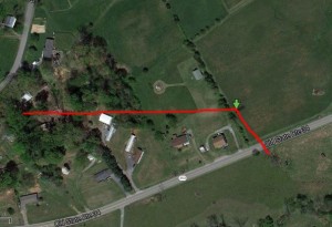
Many deeds have been researched, beginning in 1793. An east-west call has been a common denominator from the earlier deeds up until very recent surveys in the late 1900’s. Because this call has remained essentially unchanged for so many years, much certainty has been able to be substantiated. This call has basically established a “north” side and a “south” side – and will be referred to during the deeds explanations. The attached photo indicates the end of that call at the green arrow.
Due to the complexity of the deed search, not all deeds will be listed here. Rather, the ones that are pertinent. The Cemetery Survey Team has the complete file to aid any specific researcher.
These next deeds all reference the “southern” side of the call.
Deed Book EHI, Page 65 (1793) John Lyle to Jesse Payne. This deed is quiet on the meeting house and burial ground, but establishes a time and the preceding deed to the first one to mention the meeting house.
Deed Book 12, Page 211 (1810) Jesse Payne to Ephraim Brabson. “…..near the Quaker meting (sic) House, Samuel Bayless line…..” Samuel Bayless was to the north, and will be discussed below. This is the first mention of a meeting house.
Deed Book 17, Page 338 (1822) Brabson heirs to John Stormer. “…..near the Quaker Meeting house…..” and “…..including the Grave Yard Reserved for a Grounds of Burials, forever…..” This is the first mention of a burial ground. By the exact wording, it is not known whether property was simply allocated for burials, or whether burials had actually occurred.
Deed Book 21, Page 144 (1836) Stormer to Stephen Brown. “…..near the Quaker Meeting house…..” and “…..but one quarter of an acre is herein and hereby reserved for the Quaker burial ground as now used for that purpose…..” This wording would indicate that burials had occurred by this time.
Deed Book 34, Page 467 (1853) Heirs of Stephen Brown. This deed simply partitioned the Stephen Brown lands unto his heirs. It is quiet on the meeting house and burial ground. Several deeds follow here to convey undivided interests, however, they play no role in the conveyance of the entire parcel.
Deed Book 35, Page 279 (1854) Heirs of Stephen Brown to Shelby Shipley. The entire parcel is conveyed. This deed is silent on a meeting house and graveyard.
Deed Book 39, Page 93 (1865) Shipley to William Powell. The parcel in review is noted as “Tract #1”.
In 1869, Jacob W. Slonaker became owner of the “northern” side. Further discussion below at Deed Book 41, Page 531.
Deed Book 43, Page 100 (1871) and Deed Book 43, Page 93 (1871). This was a small parcel land swap between William Powell and Jacob Slonaker. In DB43/100, William Powell conveyed to Jacob Slonaker a parcel that was triangular in shape, with the northern call being the call at heart of this discussion. It escaped conveyance of the burial ground by just feet, as will become apparent further ahead in conveyances (see DB133/642 below). Parcel DB43/93 is not pertinent, nor adjacent. Ownership of the burial ground remained in Powell.
Deed Book 62, Page 504 (1890) Heirs of William Powell to James B. Susong. This deed would convey the area of the burial ground, however the deed remained silent on the graveyard.
These next deeds all reference the “northern” side of the call.
Deed Book 17, Page 217 (1821). Samuel Bayless to Daniel Bayless. This deed is completely quiet on the meeting house and/or a graveyard. This, however, would be an area that the meeting house could well have been located. The property would fall north and east of the “green arrow” in the accompanying photo. This property went through various hands, all within the Bayless family. The next deed pertinent to the northern side is below.
Deed Book 41, Page 531 (1869) Bayless to Jacob W. Slonaker. This established Slonaker as owner of the northern side. Deed quiet.
Deed Book 69, Page 605 (1894) Slonaker heirs to James B. Susong. This conveyance establishes James B. Susong owner of the property north of, south of, and completely surrounding the meeting house and graveyard area.
Between 1915 and 1920 James B. Susong conveyed several parcels to Lucretia Young.
Deed Book 122, Page 236 (1915) Susong to Young. This conveyance was for the “northern” side. Deed quiet.
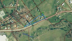
Deed Book 133, Page 642 (1918) Susong to Young. This deed becomes quite important, and is shown in a second photo below. It shows calls surrounding the graveyard. This is the first mention of the graveyard since DB21/144 (1836). Perhaps hard to see here, by plotting all the prior noted deeds, and overlaying them, the analysis presented is sound.
By this time, surveying techniques had improved and the following deeds change little, but are listed to support name changes. All future deeds mention the burial ground. It became known as “Youngs Cemetery” and is so shown on the tax parcel today.
Deed Book 202, Page 575 (1938) Lucretia Young to J. Homer Young.
Deed Book 261, Page 169 (1951) J. Homer Young adds his wife, Anne Fiske Young.
Will Book 9, Page 199 (1968) Anne Fiske Young to her children, Tom, Jack, and Jane.
Deed Book 463, Page 619 (1973) A new survey was completed in December 1972. Jack and Jane convey their interests to Tom Young and his wife, Aldaree. The deed “excepts” the burial ground.
Deed Book 630, Page 288 (1986) Tom and Aldaree Young surveyed and subdivided in April 1985. This conveyance to Dean Hardin, of a portion of the entire tract, became “subject to” the cemetery.
Deed Book 661, Page 615 (1988) Hardin to Dana Ramsey – “…..subject to…..”
Deed Book 678, Page 105 (1989) Ramsey to Frank and Carolyn Bowen. “…..subject to…..”
Roll 779, Image 1794 (2012) Bowen to Renee and Tim Moore. “…..subject to…..”
The Moores are the present owners and caretakers of the subject burial ground. The meeting house location and deeds mentioning it remained silent after DB21/144 in 1836.
BURIALS –
Based upon the information gleaned from the deeds, it would appear that the burial ground may have been active from about 1820 or perhaps a few years earlier until the 1840’s. There have been no records found to confirm that fact, or to suggest whom may have been buried there. Physical inspection of the area would indicate perhaps up to a few dozen burials were possible.
MEETING HOUSE –
Based upon the deed information, the meeting house was most likely constructed during the first decade of the 19th century. Several other meeting houses in Washington County were also established during that time frame. It appears that, by the early 1850’s, the meeting house was gone, or at least no longer used for such purpose.
Surveyed, transcribed, researched and donated to the Washington County TNGen Web April 2015 by Gordon M. Edwards, member of the Cemetery Survey Team of Northeast Tennessee.
Copyrighted 2015 by the Cemetery Survey Team of Northeast Tennessee. No part of this work may be copied without written permission from the Cemetery Survey Team.


