Two burial grounds have been located on what was the 50 acre “Mitchell Tract” (a term used in several deeds). This one, on a hill to the east, would fall on the Howren lot. The other, to the west, would fall on the Freeman-Tipton lot and has a separate entry. No evidence has been found to indicate any Freemans or Tiptons were buried at this location.
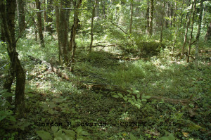
It is unknown who may have precisely established this burial ground. A longtime local resident physically pointed the location out. This individual remembered seeing a couple of the “Decker Ceramic” styled markers many years ago. Upon physical inspection in 2015, several depressions were visible, and a few planted rock markers. No sign of ceramic markers or marked tombstones were found.
This burial ground appears to be about 50’ X 50’ in size and partially covered in vinca. It is near the high spot on the lot, and near the southern border, overlooking Mitchell Branch to the east. It appears that it could be easily pre Civil War.
Much is still to be learned about this small community. Other than these two, it is unknown whether or not more graves/burial grounds exist within the area known as Kansas City. The area is remote and evidence of the old houses is long gone.
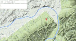
LOCATION – In the historic Kansas City community in Embreeville. Situated on the northeast corner of Washington County tax parcel 090-068.00
GPS Location: +36° 11.630, -82° 28.040
DEEDS – This deed recap is presented only with respect to the burial ground and not meant to be a history of either the Kansas City community or the families living there.
A 50 acre parcel, known as the “Mitchell Tract” was conveyed to Conrad Keicher in 1854 (Deed Book 34, Page 241). Prior deeds and/or how the name Mitchell Tract was established has not been determined. The branch that flows there is known as Mitchell Branch.
In 1855, the parcel passed to Irenius Keicher (Deed Book 35, Page 153). In 1873, the eastern 1/3 (about 15 acres) passed from Irenius Keicher to Robert Howren (Deed Book 47, Page 89) and in 1875, the western 2/3 (29 acres) passed to A.A. & F.J. Taylor (Deed Book 58, Page 259). In 1891, the 29 acres passed on to K. N. (Kansas Nebraska) Henley (Deed Book 63, Page 591). In 1895, a clarification of boundaries among several property owners, including Howren and Henley, was made with the Embreeville Iron Company (Deed Book 70, Page 457).
In 1905, K. N. Henley sold two substantial parcels of his 29 acres. A few smaller parcels were sold off, as well. It is unproven, but thought that perhaps the term “Kansas City” was coined at this timeframe, as K. N. Henley was subdividing his tract.
This subject tract remained within the Howren family for many years.
CENSUS – Partial listing by household – primary families living in the Kansas City community. It appears that Freemans and Tiptons may have been living in that area before property records indicate. A much more thorough study of this community would be needed to determine this.
Households in 1940 – Freeman, Frank & Maggie; Tipton, Oscar.
Households in 1930 – Tipton, George & Stella [Howren]; Howren, Ada; Riddle, Mary; Freeman, Frank & Mary.
Households in 1920 – Lyons, Fletcher; Tipton, Chas; Riddle, Cleveland & Mary; Tipton, Alice; Tipton, Sank; Freeman, Frank.
Households in 1910 – Orten, Robert; Howren, Addie; Freeman, Matilda; Freeman, Geo A & Alice; Lyons, Fletcher; Tipton, Wm & Alice.
Households in 1900 – Howren, James & Addie; Orten, Noah.
Households in 1880 – Keicher, Irenius; Howren, Robert; Orten, Noah.
BURIALS – It is unknown who may have been buried at this location.
Researched, surveyed, transcribed, and donated to the Washington County TNGen Web September 2015 by Gordon M. Edwards, member of the Cemetery Survey Team of Northeast Tennessee.
Copyrighted 2015 by the Cemetery Survey Team of Northeast Tennessee. No part of this work may be copied without written permission from the Cemetery Survey Team.
Return to index


