From the Hearld and Tribune, Thursday, May 27, 1875, Vol. VI (36), Jonesboro, Tennessee
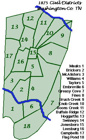
We present our readers with a map of this county showing the Districts as they now exist. It is not perfect, but will give a general idea of the Civil Dists. The 19th District is not given because we have no means of ascertaining it’s boundaries.
[Comments by William A. Burns]
In the issue of Sept. 2, 1875, Vol. VI (52), there is printed an Assessment Form of Washington Co., W.S. Strain, Assessor, listing the assessments on the different Civil Districts and nineteen are shown. Number 19 is called Fall Branch Dist. which would include territory around Fall Branch, located in the northwest corner of the county. We can sssume the 19th was made from the northern part of Dist. #13 (Hoggarth’s) and that a portion of 17th (Campbell’s) was then added to what remained of Dist. #13.
In later years, at different times, changes were made. A new county (Unicoi) had been formed by the Tenn. Legislature in the fall of 1875, made from territory cut off from Washington and Carter county. Washington Co. thus lost Dist. #7, Greasy Cove, also #18, Flag Pond. The issue of March 11, 1886 shows a delinquent taxlist for Washington Co. Districts and three changes appear-viz: Fall Branch dist. was now carried as #7 , taking the number left vacant by exit of Greasy Cove, and #18, formerly held by Flag Pond was eliminated altogether. Another change was in name only-#9 Brush Creek became Johnson City District. although I make mention of Fall Branch as Dist. #7, the fact is, the number had been assigned several years before, probably around 1876. In 1880 the Federal Census of the County shows 17 Districts and #7 is the Fall Branch community.
Sometime along in 1886 or a little later, #18 was resurrected and took on the name Limestone District. Looking at the map we can see that if Dist. #18 was formed from territory surrounding Limestone, this would naturally affect the size of Dist. #3 which is McAllister’s and others adjoining.
WA Burns

