Introduction
(written by Billie R. McNamara)
In 1835 the Twenty-first General Assembly of Tennessee provided that each county be laid off into civil districts for the purpose of electing constables and justices of the peace. Five commissioners from each county were appointed to make the divisions, after which two copies were to be made, one to be placed in the county court clerk’s office and the other in the secretary of state’s office in Nashville where it was to be “carefully preserved.” This means that even though the county court clerk’s copy may have been lost in a fire, a copy should still be available from the state. Evidently, someone did not live up to his charge, because the copies for a few counties cannot be found. However, the names of the commissioners appointed in each county are listed in the Public Acts of the State of Tennessee.
Included in the next section are portions of the act most pertinent to understanding how the civil district divisions were made.
Legislative Act to Establish Civil Districts in Tennessee Counties
(transcribed by Billie McNamara)
From the Public Acts of the State of Tennessee
Passed at the first session of the Twenty-first General Assembly which was begun and held at Nashville on Monday the Fifth Day of October in the year One Thousand Eight Hundred and Thirty-five.
Chapter 1
An Act to provide for the laying off the several counties in this State into districts of convenient size, within which justices of the peace and constables shall be elected, and for other purposes.
Section 1 – Be it enacted by the General Assembly of the State of Tennessee, That there shall be appointed by joint resolution of both branches of the General Assembly, five suitable persons as Commissioners in each county in this State, a majority of whom shall be competent to act, to lay off the respective counties into districts of convenient size, regard being had both to territory and population, for the purpose of electing Justices of the Peace and Constables therein; and that said Commissioners shall receive for their services such compensation as the County Court, in their discretion may allow, to be paid out of any moneys in the county treasury not otherwise appropriated.
Section 2 – Be it enacted, That the commissioners aforesaid, or a majority of them, in each county in this State, shall have full power and authority to lay off their counties into districts for the purposes aforesaid; and in laying off the same shall be governed bythe following ratio of population, to wit. Each county which contains three thousand qualified voters or upwards, according to the enumeration of 1833, shall be laid off into twenty-five districts; that each county which contains twenty-five hundred qualified voters and under three thousand, shall be laid off into twenty districts; that each county which contains two thousand qualified voters and under twenty-five hundred shall be laid off into seventeen districts; that each county which contains fifteen hundred qualified voters and under two thousand, shall be laid off into fifteen districts; that each county which contains one thousand qualified voters and under fifteen hundred, shall be laid off into twelve districts; that each county which contains seven hundred qualified voters and under one thousand shall be laid off into ten districts, that each county which contains less than seven hundred qualified voters, shall be laid off into eight districts; which districts, when laid off as aforesaid, shall remain fixed and permanent until the General Assembly shall otherwise direct.
Section 4 – Be it enacted, That the commissioners aforesaid shall, at the time of laying off said districts, designate a suitable place, as near the centre of each district as practicable, for the purpose of holding elections for the election of the officers aforesaid, and other county officers, and which shall continue to be the place for holding elections in said district until altered or removed by a majority of the qualified voters residing therein.
Section 5 – Be it enacted, That in laying off said districts, the commissioners shall bound the same by county lines, rivers, creeks, branches, mountains, ridges, roads (public and private) section or range lines, or such other marks, natural or artificial, as to said commissioners shall seem necessary and proper to make said boundaries notorious: Provided, that said commissioners shall not be authorized to employ surveyors in designating said boundaries.
Section 6 – Be it enacted, That it shall be the duty of said commissioners in each and every county of this State to number each and every district, and to make out a complete record of the boundaries of each when laid off under their hands, and also a copy of the same, one of which shall be filed in the office of the county court clerk in which it is situated, and the other shall be forthwith transmitted to the office of the Secretary of State, directed to that officer, and it shall be his duty carefully to preserve the same in his office.
Section 7 – Be it enacted, That said commissioners shall make out two fair ideal plats of their respective counties, and of the respective districts in each as laid off by them, one of which shall be returned to the Secretary of State, and the other shall be returned to the office of the County Court Clerk, and to be by him recorded for the use of the public, or any individual who may wish to examine the same.
Dividing Bledsoe County
In 1836, the Tennessee State Legislature appointed 3 citizens of Bledsoe County to “lay off the county into districts for the purpose of electing Justices of the Peace and Constables.” Isaac Stephens, Samuel McReynolds and Samuel L. Story divided the county into 10 districts, each with a designated voting place, the northern most being District 1 and the southernmost being District 10.
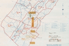
Take a look at the recreation of an 1836 map of the county, above, and read the descriptions of each district (below), which include the places where elections were held.
It is important to note that in 1856 Cumberland County was created and took Civil Districts 1, 2, and 3 as part of its territory and in the same year the State Legislature detached the 10th district along with the 1st and 2nd districts of Marion County to become part of Sequatchie County.
Descriptions of Bledsoe Civil Districts
(transcribed by Nancy Cole)
District 1
The 1st District to Commence at the County line near Robert Burks & run with the said road leading from said Burk to Craven Sherrills at the head of Sequatchie Valley, thence a direct line from said Sherrells to Lowrys including said Lowrys, thence a direct line to the bounds of the County, thence with the bounds of the County to the begining of said District including said Burk. And the place of holding election in said District to be a John Stewarts.
District 2
The 2nd District to commence at the County line near said Robert Burks and to run with the line of the 1st district to Craven Sherrills thence a S.E. course from said Sherrills to the County line thence with the bounds of said County to the begining of said district and the place of holding elections in said district to be at Pleasant Gipson, in the Grassy Cove.
District 3
The 3rd District to run with the Southern boundary of the 1st and 2nd districts across the county including Craven Sherrells and to the lower line of Lot No. 1 including said Lot thence from the extreme ends of said Lot each way to the bounds of the county thence with the bounds of the county to the Southern boundary of the 1st and 2nd districts. And the place of holding elections in said district to be at Tolletts mill.
District 4
The 4th district to include Lots No. 2 and 4 and to extend from the extreme ends of the upper line of Lot No. 2 each way to the bounds of the county, and from the extreme ends of the lower line of Lot No. 4 each way to the bounds of the county, and the place of holding election in said district to be at Thomas Swafford.
District 5
The 5th district to include Lots No. 5 & 6 and to extend from the extreme ends of the upper line of Lot No. 5 each way to the bounds of the county, and from the extreme ends of the lower line of Lot No. 6 each way to the bounds of the county. And the place of holding election in said district to be at Jonathan Dentons.
District 6
The 6th district to include Lots No. 7 & 8 and to extend from the extreme ends of the upper line of the 7th Lot each way to the bounds of the county and from extreme ends of the lower line of the 8th Lot each way to the bounds of the county. And the place of holding election in said district to be at Pikeville.
District 7
The 7th district to include Lots No. 9 & 10 and to extend from the extreme ends of the upper line of the 9th Lot each way to the bounds of the county and from the extreme ends of the lower line of 10th Lot each way to the bounds of the county. And the place of holding elections in said district to be at Valentine Springs.
District 8
The 8th district to include Lots No. 11 & 12 and to extend from the extreme ends of the upper line of the 11th Lot each way to the bounds of the county, and from the extreme ends of the lower line of the 12th Lot each way to the bounds of the county. And the place of holding election in said district to be at Isaac Robinsons.
District 9
The 9th district to include Lots No. 13 & 14 and to extend from the extreme ends of the upper line of the 13th Lot each way to the bounds of the county, and from the extreme ends of the lower line of the 14th Lot each way to the bounds of the county. And the place of holding elections in said district to be at Aaron Hughs.
District 10
The 10th district to include Lot 15 & all of the 16th Lot that lies in Bledsoe County, to extend from the extreme ends of the upper line of the 15th Lot each way to and with the bounds of the county. And the place of holding elections in said district to be at William Jewells.