Index
Acknowledgments
Preface
Introduction
The First Decades of A New County
Uneasy Tranquility: 1850-1860
Lost Tranquility: 1861-1865
Road to Recovery: 1866-1890
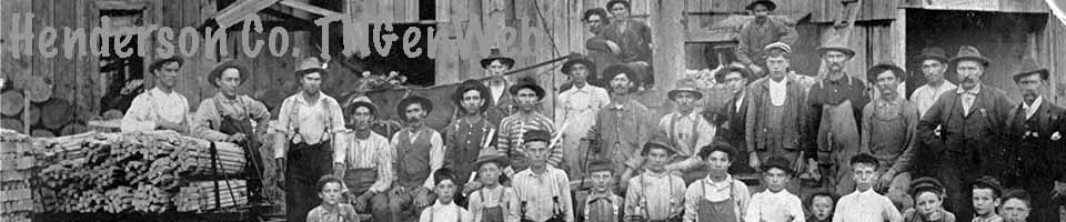
Period of Enthusiasm: 1890-1920
Post World War I
World War II to Present
Miscellaneous Pictures
Suggested Readings
Appendix
About the Author
Introduction
G. Tillman Stewart
From Henderson County by G. Tillman Stewart, Tennessee County History Series, Joy Bailey Dunn, Editor, Charles W. Crawford, Associate Editor, 1979, Memphis State University Press. Thanks to G. Tillman Stewart's son George Stewart for granting permission to publish this book.
Henderson County has one of the most diversified topographies of any West Tennessee county. Lexington, the county seat, at 720 feet above sea level, has the highest elevation of any county seat in the western part of the state. The county's highest lands are located on the Highland Ridge that passes through the county, entering in the southeast near old Jack's Creek Church and continuing in a northerly direction into Carroll County. This ridge also is known locally as Feather Ridge. Water that falls on the east side of the ridge flows into the Tennessee River; water that falls on its west side flows into the Mississippi River. The ridge continues through Sand Ridge Community, east of Union Cross Community, and goes out of the county at a point northwest of Wildersville. Approximately 60 percent of the county lies east of this ridge, which at one time was known as Purdy Range in honor of John Purdy, one of the county's founding settlers.
Under the land of Henderson County is a limestone formation of the Mesozoic Era. This layer of limestone is a sedimentary formation that crops out at the Tennessee River, where hundreds of fossils can be found embedded in rocks, and it extends to the Mississippi River and, in some cases, beyond.
This diversified land surface created numerous streams, many of which were fed by everlasting springs of freestone water. These streams formed brooks or branches that have creeks as small tributaries. These creeks meander through meadows and leas, between ridges and hills, and into Beech River.
Named for the immense number of large beech trees in the river bottom, Beech River is the largest stream of water in the county. The river rises some seven miles northeast of Lexington and flows southwest until it reaches the present city limits where it forms Beech Lake. Leaving the man made lake, it flows south about a mile, forms a semicircle around Lexington, and then runs eastward emptying into the Tennessee River above Perryville.
Beech River has several main tributaries. Wilson Branch, now called Town Branch, rises near the Lexington cemetery and flows directly into the river. This branch was named for Samuel Wilson, the founder of Lexington. Wolf Creek, named for timber wolves that inhabited its headwaters at what has been known as Council Woods, rises in Palestine Community and flows east to empty into the river. Lick Branch, named for a salt lick near its origin, is as large as some creeks and rises near what is known as the Fred Woods place and flows east into the river.
Piney Creek heads about a mile east of the Highland Ridge near what was known as Thomas Community. The creek flows east a short distance and fills Pine Lake, formed by the dam built by the Beech River Watershed. Piney Creek runs through a canyon known as Pine Knobs. Its Big Knob and Little Knob are a mile in length and are covered with large growths of tall native pine trees, hence the name, Piney Creek. It empties into Beech River after leaving Pine Knobs.
Dry Creek, so called because it does not run fully during the entire year, rises on what is known as the G. H. Buck place and flows south into the river. A dam forming Sycamore Lake is a part of this creek. Cane Creek rises near Highway 100, not far from what was known as the Jones Austin farm, and empties into the river east of the Chesterfield Middleburg Road. Although dry part of the year, the creek's bottomland still contains rich soil. The creek received its name from the large canebreaks growing along its banks. To the north, Big Creek rises some five miles from Highway 20, forms a lake, then flows directly south into the river. Browns Creek, named for the early settler Nathaniel Brown, rises north of its lake, flows through south Natchez Trace Park, and forms Pin Oak Lake.
Haley's Creek rises a mile and one half southwest of the John A. McCall farm, forms Red Bud Lake, then flows directly south to the river. Lick Creek, named for the several salt licks near its heading at the Reed School Community, flows south to the river. Harmon's Creek, named for Major John Harmon, rises west of Oak Grove Community and flows south to the river. Owls Creek, named for the large number of owls that roosted nearby, rises from a large spring on what was known as the Bass place and flows directly to the river. Through these tributaries Beech River drains approximately one third of the county.
Another river, the Big Sandy, rises in the Longsought Community, flows north through Carroll County, turns slightly east through Benton County, and empties into the Tennessee River in Henry County. Big Sandy rises in a section of sandy land, hence its name. Beaver, North Fork, Big Beaver, and Olive Branch are its tributaries. Cub Creek surfaces in the northeast part of the county, forms Cub Creek Lake at Natchez Trace Park, flows east through Decatur County, and empties into the Tennessee River. Doe Creek appears a mile north of the Sardis-Scotts Hill Highway and flows through part of Presley Community, southeast into the river. Little Hurricane Creek rises two miles northwest of Sardis and flows into Middleton Creek. Big Hurricane rises south of Reagan, and Middleton Creek rises south of Center Hill Community; both enter Chester County and continue to White Oak River, also a tributary of the Tennessee River. All these rivers, creeks, and streams drain the county east of the Highland Ridge.
Middlefork Creek, one of the numerous prongs of Forked Deer River, rises near Stegall and McAdams communities, flows in a westerly direction into Madison County. There it joins the south fork and Is one & several creeks on the west side of' the divide. Another prong rises south of Juno about one mile south of Highway 20, curves around Huron, then flows west into Middlefork. The north fork, larger than the other two, rises near Bargerton, flows southwesterly, and then northwesterly to empty into another prong near the Madison-Carroll County line. Spring and Griffin creeks are small tributaries.
About six miles on each side of the Highland Ridge are numerous everlasting springs. At one time there were five springs located within 100 yards of the Palestine Church. The main public spring has been in use for over 150 years. Its clear, cool water runs out of a pipe located several inches above ground. The top of the spring is covered with concrete, and 30 inch tiles bank the ground for eight feet. People still stop there to quench their thirst.
An unusual spring, known as Boiling Spring, was located 150 yards behind Palestine Church. Water boiled and foamed out of the ground from an eight to ten foot diameter hole. It has been reported that a person could pitch a fence rail into the hole and watch it disappear, only to see it shoot up and out of the hole later. This spring mysteriously changed location each year but never moved out of a 15-yard radius. Sand and top soil, carried by Wolf Creek, have destroyed this miracle of nature. Today, all that remains of the spring is a small trickle of water.
Early settlers built homes close to these springs. Later, as they moved or settled on lands where springs did not exist, wells were dug. Water usually could be reached at a depth of 20 to 50 feet. Wells later were bored by using augers, measuring about six inches in diameter, pushed by two men. Hundreds of homes used cisterns, holes dug in the ground near the house. Rain that fell on the roof of a house was channeled into the cistern and was considered pure enough for cooking, washing, and drinking.
Henderson County has a variety of soils ranging from the rich soil located in well drained valleys to that known as nonproductive "crayfish" soil. The red soil on hills and flat lands was considered at one time to be poor, but this clay loam, when given proper care, has proved to be valuable. Lexington clay, which begins in what is Rhodes Town near Laster School and extends eastward to include the late J. D. Roberts' farm, is considered to be good quality soil, ranging from three to six miles in width.
The Soil Conservation Service of the U.S. Department of Agriculture, in cooperation with the Tennessee Agricultural Experiment Station and the Tennessee Valley Authority, conducted a soil survey in 1960. The survey report included maps of the different kinds of soil on every farm in the county and divided the county's soil into six main types with variations: Ina-beechy-Hymon; Ruston-Lexington; Lexington-Ruston; Shubuta-Cuthbert; Dulac-Tippah-Cuthbert: and Ruston-Shubuta-Silerton.
The climate of the county is similar to that of most counties in West and Middle Tennessee. The average temperature from 1940 to 1970 was 62.4 degrees, average rainfall, 50 inches, and average snowfall, 5.4 inches. The frost-free period generally is from March 26 to November 10, or about 208 days. January is usually the coldest month, and July, the hottest.
Henderson County was a hunter's paradise when settlers first arrived. County topography was conducive to the propagation of wildlife. Forests were full of hickory and persimmon trees which provided food for both man and small game. There were also chestnuts and hazelnuts. Wild blackberries, dewberries, and strawberries were delicacies consumed by man and such animals as rabbits, raccoons, squirrels, and groundhogs. Area carnivores were panthers, wolves, wildcats, and bobcats, and the small furbearing animals were mink, muskrat, weasel, and red and gray fox. Colonies of beavers thrived on most streams, and their dams sometimes backed water onto cultivated crops. Black bears roamed the hills and valleys. Buffalo were plentiful west of Highland Ridge. However, due to their size and to the value of their flesh and hide, they were soon slaughtered. No mention of buffalo in Henderson County was made after 1835.
When Henderson County was settled, song birds, both migratory and native, were abundant. Quail and wild turkey were plentiful. Wild pigeons were prized because of their plumage and delicious meat. Cardinals, bluebirds, mockingbirds, house wrens, jaybirds and whippoorwills were present. Martins, imported from Europe, quickly spread throughout the land. Many farmers built houses for these birds because they fought hawks and other predatory birds. In recent years, the number of cardinals in the county has diminished, and the bluebird is practically extinct. Crows and red-headed woodpeckers have fallen prey to man's disruption of nature's balance, as have the redwing blackbirds and mockingbirds. Turkey buzzards are rare, and bald eagles are no longer seen in the county. Predatory birds, such as hawks and owls, once plentiful, still exist in small numbers; but large hoot owls or horned owls are rare.
The county has never been inhabited by rattlesnakes, although some existed at one time on Pine Knobs. In recent years, several have been found at Crawford Springs Community near the Madison County line. Area poisonous snakes are copperhead, cotton mouth, and water moccasin. Chicken snakes and black racers have been, and still are, the most plentiful of the harmless snakes. Toads and frogs are in greater supply now than when the county was young, since there were no man made swamps then where these creatures seem to thrive best. Among the scavengers, the opossum is most plentiful.
Early settlers found the county's virgin timber to be of excellent quality, and the area is still considered to be a hardwood center. Trees dominant in the county are red and white oak, blackjack, hickory, poplar, beech, cedar, sweet gum, and tupelo gum, as well as chestnut, sycamore, black walnut, and willow. Although much cutting occurred several times, there is still timber, due largely to the education of timber owners and especially to professional harvesting techniques.
High quality clay and sand have been the only materials commercialized to any extent in the county. They were used in the county's many brick kilns, primarily to make bricks for chimneys and commercial buildings. Kilns usually were located near construction sites. In the middle 1920s a brick kiln was operated on what was known as the Jowers' property, near the present location of the Brown Shoe Company. Business was moderate, but the kiln fell victim of the Depression. About 1932 and continuing for more than 30 years, Ayers Mineral Company had a plant in Lexington that processed white, red, brown, and orange sand which wits shipped across the nation and to foreign countries.
Oil represents a yet untapped resource. Some geologists believe there is oil under the county's limestone layer. However, at present, the quantity of oil is unknown, and it is too expensive to drill, but oil leases have been made for several thousand acres of land.
Early Inhabitants, Pioneers, and Settlers
Mound builders, who seem to have lived mostly in the Mississippi Valley, Ohio, Indiana, Iowa, Tennessee, and Louisiana, were obviously among the first inhabitants of Henderson County. A physically small people comparatively, they built mounds for burial purposes, for defense, and apparently for other ceremonious activities. Examples of these mounds in West Tennessee are at Pittsburg Landing on the edge of Shiloh Battlefield, at Pinson, and at the experiment station in Jackson.
Pinson Mound is only four miles from what was originally the west line of Henderson County. Artifacts, identical to those found near the Pinson settlement, have been found as far east as Lexington. A smooth oval boulder used to crush grain was found near Lexington a decade ago. It was five and one half inches long with a four inch diameter and weighed seven pounds.
The first Indian tribe in the county probably was the Shawnee tribe of the Algonquin. After about 50 years, however, the Cherokees and Chickasaws forced the Shawnees out of West Tennessee. The Creeks and these tribes hunted and made temporary homes in what is now Henderson County. These Indians tended to build permanent communities near large or navigable rivers which served as a natural defense. For this reason, no permanent Indian settlements were located in Henderson County. However, parties of Indians frequently pitched camp near an area spring to hunt and trap for miles around.
It was inevitable that these tribes would clash over possession of limiting rights. There is evidence that, three battles occurred in the county: one near Middleburg; one near Reagan, north of the head of Hurricane Creek; and the other, four miles south of Lexington on what is known as the Henderson County Poor Farm. Large numbers of arrowheads from the different tribes have been found as the land has been cleared. By the time settlers arrived, the Chickasaws had the territory almost to themselves.
The first white men in the area, according to the beliefs of some historians, were the Spaniards. When the Spanish explorer Hernando De Soto marched west in 1541 from the Carolinas through northern Alabama and northern Mississippi on his way to the Mississippi River, some of his men, in foraging for food, may have come as far north as the southern boundary of Henderson County. Two Spanish coins were found in 1865 or 1866 close to the banks of Hurricane Creek near where it enters Hardin County. Now in the Bee Grissom collection, these badly corroded coins were uncovered by soil erosion. The date on one coin appeared to be 1520, so it is possible that some of De Soto's men did trade with area Indians.
After the French trader M. Charleville built a store at Salt Lick on the Cumberland River where Nashville now stands, a trail was made from Port Prudhomme on the Chickasaw Bluffs to Salt Lick. The trail led through north Hardin County, then through Henderson County, and crossed the Tennessee River into Humphreys County. This was a known trail when the English settled East Tennessee and even before the beginning of the Revolutionary War. According to some written records French traders may have been among the first white men to enter the Henderson County area.
Pioneers are that breed of people who chose to settle in a wilderness where few dare to tread. Such was the case when the land west of the Appalachian Mountains was first settled. Some pioneers came with a desire for new land, others to escape political or religious unhappiness, and others for adventure-they all shared a common wanderlust. This pattern was repeated several times, as early settlers continued to move westward. Some, however, remained behind and formed the foundation for a permanent place to live, work, love, and die.
Before settlers legally could settle in what is now Henderson County, it was necessary for a settlement to be made with the Chickasaw Indians who still claimed the land. General Andrew Jackson, Isaac Shelby, and John Overton were commissioned by the federal government to negotiate purchase of the land. The Chickasaw Cession was made on October 19, 1818, which ceded all lands in what is now West Tennessee. Another treaty in 1823, known as Overton's treaty, released all claims to any West Tennessee land.
Thus, it seemed as if everything was ready for settlement of' the area. Settlers would be spared the Indian wars that the settlers of East and Middle Tennessee had to endure. There was a drawback, however. At the end of the Revolutionary War, the state of North Carolina was virtually bankrupt. In order to pay its war veterans, grants were given for land in Tennessee, part of North Carolina at the time. After Tennessee became a state, squabbles concerning the legality and the boundaries of these grants arose. Finally, resolutions occurred when the governor of Tennessee signed the land grants.
Not all North Carolina veterans moved across the mountains to live on land given to them; many sold their land grants for small amounts of money to land speculators who in turn sold them to settlers. These settlers moved to where they thought their land was located and had it surveyed. Consequently, property boundaries in many instances overlapped; it took some time before such conditions were cleared and pioneers were able to create new communities from the wilderness.
There is no question that Joseph Reed was the first settler to locate in Henderson County, although at the time he thought he was in Perry County, as did the surveyor Samuel Wilson, who later founded Lexington. The original warrant for Reed's land was issued October 11, 1820-little more than one year before Henderson County was created. Reed lived on his land four years before he actually received his land grant deed.
Reed was indeed a true pioneer. In the summer of 1817, he and his two sons, Jack and William, left the central part of North Carolina and crossed the rugged mountains into East Tennessee. There they made a small raft of logs and floated down the Tennessee River, pulling to land only long enough to hunt for wild game and to sleep on the ground at night. When the Reed party reached the mouth of Beech River, they abandoned their raft and trekked on foot until they came to a large, cold spring. This spring of sweet tasting water came out of the ground near a small bluff, an ideal place to settle. Wandering through the surrounding forest, they made friends with a party of Chickasaw who hunted and fished with them.
Late that fall, Reed left his teenage sons in the care of their Indian friends and retraced the 600 miles across the mountains and rivers to North Carolina. In the spring of 1818 he returned in a one horse cart with only enough necessary possessions to reach Tennessee, where his family would make a new home. Reed also brought some slaves, indicating that he was a man of some means who did not have to leave his settled North Carolina home.
Reed built a log house near the spring in 1818. The logs were cut on the pine knob and moved two or three miles to where the house was erected. These same logs exist today as part of the home and smoke house belonging to Goy Snider, a great great grandson of Reed. This land grant tract is one of the few in Henderson County that still belongs to direct descendants of original settlers.
In the spring of 1817, John Bailey, a 15 year old boy, left his home in the foothills of North Carolina and headed west on foot. He carried with him only his muzzle loading rifle, a powder horn, and a hunting knife, Undoubtedly a boy with a spirit of adventure, he continued west until he joined a group of Chickasaw near where Reagan Community is now located. After living with them for a year, he returned to North Carolina, remained there for a year, and then went to Kentucky for two years. Unable to forget West Tennessee, he came back, married, and became an ancestor of one of the county's famous families. He is buried at Union Hill cemetery near where he spent most of his life.

Another Reed House was erected about 1830.
It has been restored and relocated at Lakeland
near Memphis by its owner, Edward Tony Reed,
a direct descendant of Joseph Reed.
Shortly after the Reed family and slaves were settled to the task of making a new home, others made their way into the area. Samuel Wilson settled on 726 acres in what was to become Lexington, with his cabin located where the present United Methodist Church is situated. Abner Taylor came to the area almost at the same time. These two men furnished excellent leadership as the groundwork and organization of county self government was laid. Wilson came to Henderson County from Wilson County, where he and his brother David, together with their father Zaccheus, had helped found that county. He also obtained other land grants in 16 counties.
Taylor came to Henderson County from the part of North Carolina that is now Carter County, Tennessee, and obtained a grant for 26 acres next to Wilson's land. He also obtained another land grant for 620 acres; with his brother, James, he obtained even more land grants. Like Wilson, Taylor was a land speculator and a shrewd, well educated businessman who took an active part in the civic life of any community in which he lived. He secured land grant deeds in 11 counties throughout Tennessee.
Other early settlers were just as zealous in building a new county government, but they did not have as much time as did Taylor and Wilson. Reed helped, but his farm and community took much of his time. David and Zaccheus Wilson soon joined Samuel in Henderson County and settled north of what is now Wildersville. There they shared their previous experiences in local government. Another Wilson brother originally settled near what is now Sand Ridge, found locating water difficult, then moved further west to a prong of Forked Deer River. He became the ancestor of many Wilsons in that part of the county.
A majority of area settlers were from Middle and East Tennessee and North Carolina. These pioneers were of stern character, the majority being Scotch Irish Presbyterians. Few settlers came from Alabama, Virginia, South Carolina, Kentucky, and Pennsylvania. Some traveled by land, driving their flocks and hauling their few household goods by wagon or pack horses; some came by water down the Tennessee River, stopping at favorite landing places, usually at the mouth of a creek or small river.
In 1819 and 1820, as soon as it became known that the Chickasaws had ceded all West Tennessee lands to the United States, settlers entered the county regularly. Shortly after Wilson and Taylor settled at what is now Lexington, Dr. John A. Wilson settled near there, becoming the first doctor and first professional man to settle in the county. He also became the first merchant, fur buyer, and county court clerk, and he operated a farm with the help of slaves. Wilson trained two female slaves to serve as mid wives. His fee for a house call was 50 cents regardless of the distance and time of day. Payments were made in anything salable, such as beaver or fox skins, beeswax, tallow, or produce. In 1824, a Dr. S. Pierce also settled in Lexington and began an active practice. In 1827, a Dr. Miller also opened his office in Lexington; however, the 1830 census did not show his living in the county.
Major John T. Harmon settled near the headwaters of Big Sandy. He had served under General Andrew Jackson in the Creek War and at the Battle of New Orleans. Early in 1820 Thomas Hamilton settled at what was later known as Pleasant Exchange; records indicate that he was its first settler. He was soon followed by William Cain and George Powers.
John Purdy settled between Jack's Creek and Mifflin. He was a deputy surveyor, helping settlers locate their land properly; later he founded the town of Purdy which was the first seat of McNairy County. He surveyed what is known as the Lexington-Purdy Road, now Highway 22A. James Baker, his family, and five slaves settled eight miles northeast of Lexington. William Dismuke and his family of seven settled on the north fork of Forked Deer River, about two miles northwest of Poplar Springs. Two families of Shacklefords settled in the northern part of the county, but one family soon moved near Haley's Creek.
The Binghams, Brigances, and McClures settled in the south part of the county near the Hardin County line. The Trices and their slaves settled east of what is now Crucifer and near what is known as Timberlake. Settlers locating on Browns Creek included Matthew Lewis, soon followed by Asa Davis; Josiah Reagan near Reagan, which was probably named for him; Levi Truett in the community that took his name; Abraham Derryberry, ancestor of that prominent family, in the eastern part of the county; Nixon Walker near Old Lone Elm; John Myracle at Big Sandy near Wildersville; Absolum Brooks near Lexington; Joseph Smith and his three slaves four miles south of Lexington; John and Gilbert Blankenship near Oak Grove Community; John and Jerry Crook at Middle Fork Community; and William Cawthorn and family with their eight slaves near Mifflin. The most populated early settlements were Beech River, Browns Creek, Christian Chapel, Cross Plains (now Crucifer), Independence, Jack's Creek, Lexington, Middlefork, Middleton Creek, Mifflin, Pleasant Exchange, Prospect, and Reagan.
Others who settled in the area before it became a county were William Adcox, John Bray, Midget and Gregory Brooks, William Brooks, Leander Brower, John Carnall, John Carver, Silas Clark, James and, Thomas Emerson, Cason Gilliam, Solomon Gilliam, J. J. Hill, Jeremiah Ingrahan, G. Kerherdon, Donald Kizer, Jack Little, William McDaniel, John Melton, Thomas Mitchell, T. C. Muse, Webb Phillips, Job Philpot, Allen Pollock, Barton and Charles Pope, Calied Rice and wife with nine children, Martha Roberts with five children, John N. Steele with four slaves, John Stewart, Lemuel Stratton, E. H. Tarrant, Richard Thomas, Jacob Tomlin, John Tubbs, Phillip Walker, Henry West, Ben White, William Wilkerson, and Caleb Wood.
The exact population of Henderson County at the time of its creation is unknown since the federal census had been the year before the county's creation. Estimated county population in 1821 ranged from 1500 to 2500. The first federal census of the county in 1830 showed a population of 8741, of which 1442 were slaves and five were freedmen. There were fewer than 1000 slave owners. The first ten years of the county represented the fastest growing period in its history. By 1840, the population had grown to 11,875 and by 1850 to 13,164.
Pioneer parents, strongly believing in the work ethic, taught their children at home until schools were established. The work day started early and lasted well into the evening hours. They slept well on crude beds of straw or bear hide on dirt floors or, if the house had a floor, on beds made by driving pegs into the walls. All cooking was done in a fireplace, since it was 60 years later before cooking stoves were introduced into the county. Knives, forks, and spoons used for eating were frequently made of wood. Oxen, mules, and horses were the usual beasts of burden. Some families had milk cows. All stock had to be guarded from wild beasts. Corn and vegetables were the principal crops, and some cotton was grown.