
© Frederick Smoot, 1998
INTRODUCTION
When doing land record research in Warren County, we immediately find two problems. First, the county Plat & Survey Book Vol. 1 starts in the year 1824. Second, the Deed Book “A” is forever missing its first fifty five pages. However, with a little searching, you may find some early records that are in Nashville. Earlier Warren County records are found in three primary areas.
North Carolina land grant records. ( Generally, these are pre-1806 records, and therefore not very useful to the Warren County genealogist.)Normal Warren County records are available in these areas.
Tennessee Surveyor District records. (1807-1824)
Tennessee Land Grant records. (1806 onward. There is a card file index for these grants at TSLA, Nashville.)
County Deed Books.1814-1990All of the above resources are available on microfilm from the Tennessee State Library and Archives in Nashville. The microfilms may be purchased from TSLA, 411 7th Avenue North, Nashville, TN 37219.
County Entry Books.
Grant Books, 1824-1901.
County Plat and Survey Books. 1824-1990
(There is very little information on land entries, surveys, or grants later than 1838 in the County records.)
At the Warren County Court House, you will find the original County Deed, Entry, Grant, and Plat and Survey books.
North Carolina’s Military District & Middle District,
~ or ~
The Time Before The Surveyors Districts
In 1782, in what is now known as north Middle Tennessee, the North Carolina Military Reservation, sometimes called the Military District, was created. The Officers and Men from North Carolina that served in their Continental Line during our War of Independence were issued Military Warrants which were redeemed in land within the Military Reservation. When the title to the land passed to the individual, it came as a land grant. Additionally, many preemption claims in that Reservation were honored with land grants. Warrants for land and land grants were both given by North Carolina even into Tennessee’s Statehood period. Some North Carolina Warrants were also used for land outside the Reservation. North Carolina appears not to be overly concerned the land claims of the Indians. In North Carolina’s view, the Cherokee had joined Britain during the war and were therefore forfeited their land rights because they were on the losing side. North Carolina's Middle District was just east of the Military District and encompassed much of today’s Upper Cumberland and was considered Indian land. This Middle District ran southward and then westward to form a district that included much of the later Warren County. An example of that is the two 1796 grants, of 5,000 acres each, to Thomas Wade. These two adjoining grants were in the North Carolina Middle District, on Hickory Creek, an area that was to become Warren County. Clearly, that area, and much more, was Indian land and was not ceded by the Cherokee until 1806. (Dearborn’s Treaty, 7 January 1806.)
The Surveyor Districts
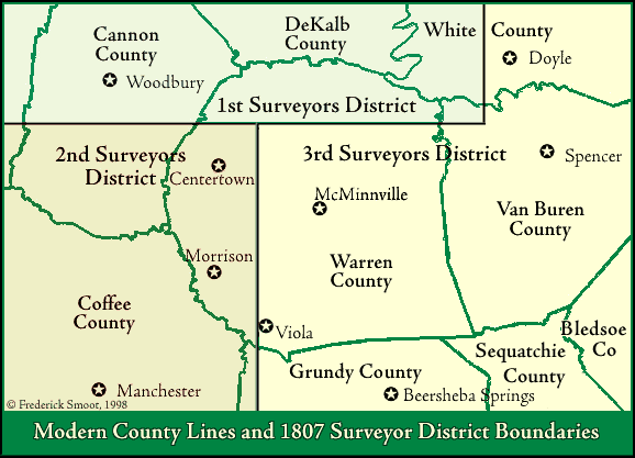
In 1806, Congress of the United States, North Carolina, and Tennessee reached an agreement for solving the problems regarding the honoring of North Carolina Military Warrants and the claims of settlers on vacant lands in Tennessee. Also in 1805, certain Indian claims were extinguished by treaty. In 1806, the Tennessee legislature at Knoxville established its Surveyor's Districts. Tennessee was divide into two sections, East and West. Today we know that “West” as Middle Tennessee. The 1st, 2nd, and 3rd Surveyors Districts were established in the then “West Tennessee.” In 1806 when the 1st District was formed, it became the largest of all the Surveyors Districts. The 1st District enjoyed the same boundaries as the original Military Reservation. The 2nd & 3rd Districts were formed south and east of the 1st District.
Greater Warren County And Old Records
The Warren County’s original bounds encompassed a significantly greater area than its current bounds. The Surveyors Districts records were not affected by county line changes of Warren County in any way. As a word of caution, however, you will find records marked Warren County that today would fall into DeKalb, Cannon, Coffee, Grundy, Sequatchie, and Van Buren Counties.
Before Warren County was formed, North Carolina granted land there. We will find pre-1806 grants that would say North Carolina Military District or North Carolina Middle District. We might even see Sumner or some other county mentioned as the county location. The landmark could be recorded as simply as “a south branch of Cumberland river.”" The earliest Surveyors District records say “White County” for what later became Warren County. The earliest 2nd Surveyors District surveys for “Warren County” are the surveys for William Stroud, Joseph Guest, and William Fears. This land on the “West fork of Hickory Creek, a branch of the Cainey fork (Caney Fork) of Cumberland River” was then in “White County.” Surveyed 31 July 1807, these three adjoining tracts were near today's Morrison.
How The Three Districts Were Situated In Warren County
The east/west line of the 1st District, known as the Military Line, runs from a point near Bone Cave Creek/Laurel Creek area in Van Buren County, crossing Rocky River, then the Collins River, about 175 poles or 2,887 ft. north of the mouth of Mountain Creek at the Collins River, then very near or through the graveyard of the Concord Church on Concord Road in Warren County. It then runs to a point very near the mouth of Tom’s Creek at the Tennessee River, now in Perry County. Any Warren County land that is north of the Military Line would fall into the 1st District. The north-south line between the 2nd and 3rd Districts intersects with the Military Line 18 miles west of the south east corner of the 1st District. This line separating the 2nd and 3rd Districts is west of McMinnville. It runs due south from the military line through the east side of a Warren County subdivision formerly known as the Walker farm, on Old Shelbyville Road, near Walker Road and then crosses the Barren Fork River. The line continues due south into Coffee County and on to the Tennessee-Alabama State Line.
Note, much of the above work appeared in the Warren County Genealogical Association Journal, Spring 1998. Please see that issue for information on the microfilms of the Surveyors Districts, 1, 2, and 3.
Table of Contents
Some Surveys Extracted From
Surveyor District RecordsA Map Showing the Township Numbering
Patterns Around Warren County
A Map Showing the Township Numbering
Patterns in the 2nd Surveyors’ District
Plats and Surveys, 2nd Surveyors District, 1807
Greater Warren County
Plats and Surveys, 2nd Surveyors District, 1808
Greater Warren County. Part IPlats and Surveys, 2nd Surveyors District, 1808
Greater Warren County. Part II
Tennessee’s 3rd Surveyors’ District Map
And Some Old North Carolina Grants
Plats and Surveys, 3rd Surveyors District, 1807-1808
Greater Warren County.
A Few Samples
A Few Surveys Around McMinnville, 1807-1808
A Plat Map
A Reconstruction
Entry Taker’s Index to Warren County Plats and Surveys
1824 ~ 1894