The names of the applicants for survey are:
William Alexander, No. 663
William Barnett, No. 651
Spencer Beavers, No. 654
Henry Bray, No. 648
Anthony Chamness, No. 657
Thomas Davis, No. 642
Thomas Davis, No. 668
William Davis, No. 640
Charles Dement, No. 665
Jacob Derryberry, No. 659
Michael Derryberry, Jun., No. 656
William Douglass, No. 649
Lewis Duncan, No. 666
Owen Evans, No. 653
William Gist, No. 650
William Guist, No. 670
John Hall, No. 645
Andrew Hogg, No. 639
James Howell, No. 641
Britain Jourdan, No. 671
Jeremiah Lakey, No. 655
John Looney, No. 660
Abraham MacDannell, Jurn., No. 638
Abraham McDannall, Senr., No. 637
Edward McDannall, No. 647
David McElivee, No. 652
William Morton, No. 644
Alsey Pulham, No. 658
Asael Ranes [Rains], No. 661
William Ranes [Rains], No. 662
Larkin Rogers, No. 646
William Smith, No. 643
Jesse Thompson, No. 669
John West, No. 667
John Woodward, No. 664
Click Here
Extracted from Book 25 { B }, Plats and Surveys,
2nd Surveyor's District, 1808, No. 621 to No. 1035.
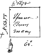
No. 654. Returned 11th June 1808 ~
State of Tennessee Second District ~ At the request and upon the application of Spencer Bevers I have surveyed for him three hundred acres of land in the County of Warren and on the head Waters of a Spring of Hickory [missing word, probably Creek] including part of the flat mountain Beginning on a Hickory by a post Oak on the said mountain running thence North fifty four chains and Seventy eight links to a Black Oak thence East fifty four chains and Seventy eight links to a Stake by the Side of a small drain in an open priarie thence South fifty four chains and Seventy eight links to a Hickory thence West fifty four chains & Seventy eight links to the beginning including his improvement which is truly represented in the annexed plat and was surveyed the 30th May One thousand eight hundred and eight by ~
Patrick Mac Eachern D.S.
David McElivee &
Jas. Battie, C. C.
Spencer Bevers Marker
Examined & correctness ascertained.
W. P. Anderson, Pr. Surveyor[NOTE: Flat Mountain, now in Coffee Co. See USGS "Fredonia" 7.5' Quadrangle Map ]
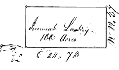
No. 655. Returned 11th June1808. Part Warrant No. 2251 for 640 acres has this day been applied and Entry made number 170 dated the 17th day of November 1808 corresponding with the within Survey and agreeably to the requirements of the 36th Section of the land law of 1807 ~
State of Tennessee Second District.~ At the request and upon the application of Jeremiah Lakey I have Surveyed for him One hundred acres of land in the County of Warren and on both sides of Barren fork of Caney fork of Cumberland River. Beginning on a White _____ on the East side of the Creek running thence East forty four chains & seventy three links to a Stake by two post Oaks , thence No. twenty two chains and thirty seven links to a Black Oak by a post Oak thence West forty four chains and seventy three links to a black oak on the North East side of the Creek within 4 poles thereof thence to the beginning including his improvement which is truly represented in the annexed plat and was Surveyed 28th day of May One thousand eight hundred and eight by ~
Patrick Mac Eachern D.S.
John Diveny &
William Kelley, C. C.
Jeremiah Lakey ~ Marker
Examined & Correctness ascertained.
W. P. Anderson, Pn Surveyor
Transmitted to Registers Office 4th May 1809
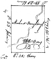
No. 656. Returned 11th June 1808 ~
State of Tennessee 2nd District.~ At the request and upon the application of Michael Derryberry Jun. I have Surveyed for him two hundred and twenty acres of land in the County of Warren and on both sides of Barren fork of Caney fork of Cumberland River. Beginning on a Walnut near the East bank thereof running thence West forty chains to a Post Oak thence South fifty five chains Across the fork to a Black Oak thence East forty chains to a black Oak thence North fifty five chains to the beginning, including his improvements which is truly represented in the annexed plat and was Surveyed the 27th May One thousand eight hundred and eight by ~
Patrick Mac Eachern D.S.
Wm. Smith &
Wm. Maricle, C. C.
Michael Derryberry ~ Marker
Examined & Correctness Ascertained.
W. P. Anderson, Pn. Surveyor[NOTE: Some descendants of the Derryberry clan now use the name Deberry.]
No.657. Returned 11th June ~
State of Tennessee Second District.~ By virtue of an entry No. 133 dated the 31st day of August 1807 founded on a Military Warrant No. 297 for Six hundred and forty acres issued for the heirs of John Colchester to Thomas Dillon by the Secretary of North Carolina 27th Dec 1803. I have Surveyed for Anthony Chamness One hundred acres of land, part thereof assignee of Joseph Terry of Thomas Dillon which leaves a balance of five hundred and forty acres unsatisfied which is Situate in White County ninth range and sixth Section including the improvement said Chamness. Beginning in the center of a square on a White Oak which Stands South 18 Degrees West 320 poles from the North East corner of said sixth Section running thence Et. fifteen chains & eighty six links to 3 Dogwoods thence South thirty one chains & Sixty three links to a Post Oak thence West thirty one chains and Sixty three links to a Stake thence North thirty Chains and Sixty three links to a stake thence East fifteen chains and eighty Seven links to the beginning which is truly represented in the annexed plat and was Surveyed the 27th day of May one thousand eight hundred and eight by ~
5 1/2 degrees variation allowed in the above plat.
Patrick Mac Eachern D.S.
Michael Derryberry
Abrm. Mac Dannell C. C.
Anthony Chamness ~ Marker
Examined & Correctness Ascertained
Transmitted to Registers Office 11th Nov 1809[NOTE: Should say Warren County.]
No. 658. returned 11th June 1808 ~
State of Tennessee Second Dist.~ At the request of Alsey Pulham I have Surveyed for him three hundred acres of land which is situate in the County of Warren and on both Sides of north fork of Barren fork of Cumberland River. Beginning on a black Oak just by Morgans old cabin and in Mac Dannells line running thence North fifty chains to a post Oak saplin thence West ten chains to a White Oak just by the bank of the Creek thence North thirty one chains and twenty five links to a black [omitted word] thence West thirty eight chains & sixty four links to Alexander's line, thence with his line South eight chains and eighty five links to a Hickory his corner thence with his line West two Chains to a post Oak in said line thence South Seventy two chains & ninety links to a stake thence East fifty one chains & twenty links to a post Oak Mac Dannell's corner to the beginning including his improvement which is truly represented in the annexed plat and was Surveyed the 26th day of May One thousand eight hundred and eight by ~
Patrick Mac Eachern D.S.
Abrm. Moorage &
Michael Derryberry, C. C.
Alsey Pulham ~ Marker Examined & Correctness Ascertained
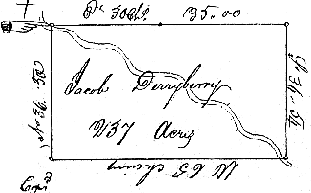
No. 659. Returned 11th June 1808 ~
State of Tennessee 2nd District.~ At the request of Jacob Derryberry I have Surveyed for him two hundred and thirty Seven acres which is Situate in the County of Warren and on both sides of North side [should be N. fork] of Barren fork of Caney fork of Cumberland river. Beginning on a Stake in the West bank thereof and in Davis's line running thence along his line East thirty chains to his corner Same couse [course?] on and pass thirty five chains to a Hickory in the open Barrens, thence South thirty Six Chains and fifty links to a Dogwood on the bank of aforesaid barren fork as aforesaid thence West Sixty five Chains to a Stake thence North thirty six chains and fifty links with the conditional line between him and Edward MacDannell to the beginning Including his improvement, Which is truly represented in the annexed plat and was Surveyed the 25th day of May One thousand eight hundred and eight by ~
Patrick Mac Eachern D.S.
Edward Bray &
Abrm. Morgan, C. C.
Jacob Derryberry ~ Marker
Examined & Correctness Ascertained
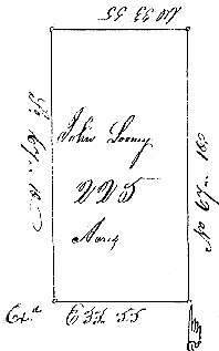
No. 660. Returned 11th June 1808 ~
State of Tennessee 2nd District.~ At the request and upon the application of John Looney I have surveyed for him two hundred and twenty five acres of land which is Situate lying and being in the county of Warren. Beginning on a post Oak on the South West side of Barren fork running thence North Sixty Seven chains and ten links to a Post Oak thence West thirty three chains and fifty five links to a stake in the open barren thence South Sixty Seven Chains and ten links to a black Oak near the River, thence East Thirty three chains and fifty five links to the Beginning which is truly represented in the annexed plat and was Surveyed the 24th day of May One thousand and eight hundred and eight by
Patrick Mac Eachern D.S.
Phillip Ranse &
Edward McDannell, C. C.
John Long ~ Marker
Examined Correctness Ascertained
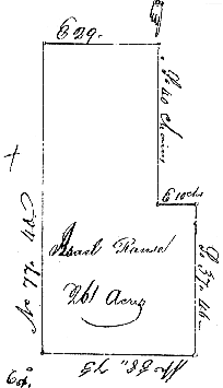
No. 661. returned 11th June 1808 ~
State of Tennessee Second District.~ At the request and upon the application of Asael Ranes I have Surveyed for him Two hundred and Sixty one acres of land in Warren County, lying and being on the North West side of the Barren fork and on both sides of Dry fork of Barren fork of Cany fork. Beginning at a Post Oak in William Rains South West boundary line of his Occupant claim of 250 acre tract running thence South forty chains to a black Oak thence East Ten chains to a post Oak a conditional line thence South thirty seven Chains and forty six links to a Sycamore by a Spring in the said Dry fork thence West thirty eight chains and seventy three links to a Post Oak in an open Barren thence North seventy seven chains & and forty links to a Stake in the open barrens, thence East to and past William Ranses corner seventy nine Chains to the beginning which is truly represented in the annexed plat and was Surveyed the 23rd day of May One thousand eight hundred and Siven by ~ [NOTE: should be 1808.]
Patrick Mac Eachern ___
Edward McDannell &
Phillip Ranse, C. C.
Asael Ranse ~ Marker
Examined & Correctness ascertained[NOTE: "Ranse", early spelling or misspelling of Rains.]
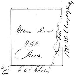
No. 662. Returned 11th June 1808 ~
State of Tennessee Second District.~ At the request & upon tha application of William Ranse I have Surveyed for him Two hundred _____ [-blank space, but plat shows 250 acres -] acres of land in the County of Warren on both sides of Barren fork. Beginning on a black Oak about fifteen chains Westof a branch running thence East forty eight chains to a post oak thence North fifty two Chains and nine links to a Stake in an open barren thence West forty eight Chains to a Hickory thence South fifty poles and nine links to the beginning which is truly represented in the anned plat and was Surveyed the 23rd day of May One thousand eight hundred and eight ~
Patrick Mac Eachern D.S.
Edward Mc Dannell &
Lewis Duncan, C. C.
William Ranse ~ Marker
Examined & Correctness ascertained
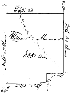
No. 663. Returned 11th June 1808 ~
State of Tennessee Second District.~ At the request and upon the application of William Alexander I Surveyed for him three hundred acres of land which is Situate lying & being in the County of Warren and on both sides of North fork of Barren fork of Caney fork of Cumberland River, Beginning on a post Oak about 2 poles West of the County road and 150 yards South East of Morgan's new improvement running thence South sixty five Chains to a black oak on the South side of the fork near Pulham's line with the conditional line West nineteen Chains to a black Oak by a post Oak thence South ten Chains to a Hickory thence West forty three Chains & fifty four links to a Stake by a White Oak and a black Oak thence North twenty five Chains to a Stake amongst post Oaks in open barren thence East Sixty two Chains & fifty four links to the beginning including his improvement which is truly represented in the annexed plat and was Surveyed the 26th day of May One thousand eight hundred and eight ~
Patrick Mac Eachern D.S.
Abrm. Morgan &
Michael Derryberry, C. C.
Wm. Alexander ~ Marker
Examined & Correctness ascertained
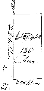
No. 664. Returned 11th June 1808 ~
State of Tennessee Second Dist.~ At the request and upon the application of John Woodward I have Surveyed for him One hundred and fifty acres of land which is Situate lying and being in the County of Warren and on the Dry fork of Barren fork, Beginning on a post Oak in Asael Ranse's South West boundary line running thence South sixty Chains to a Stake in an open barren thence East twenty five Chains to an Elm on the East bank of a pool of Water in said fork thence North Sixty Chains to a Stake thence West twenty five Chains to the beginning which is truly represented in the annexed plat and was Surveyed the 24th day of May One thousand eight hundred and eight by ~
Patrick Mac Eachern D.S.
Edward McDannell &
Phillip Ranse, C. C.
Examined & Correctness ascertained
No. 665. Returned 11th June 1808 ~
State of Tennessee Second District ~ At the request and upon the application of Charles Dement I have Surveyed for him two hundred acres of land which is Situate lying and being in the County of Warren and on both sides Barren fork of Caney fork Beginning on a White Oak near the mouth of a branch So E' of his improvement running thence Wt. fifty Chains to a Hickory thence North forty Chains to a Post Oak thence East fifty Chains to a black Oak thence South forty Chains to the beginning including his improvement which is truly represented in the annexed plat and was Surveyed the 23rd May One thousand eight hundred and eight by ~
Patrick McEachern D.S.
Wm Duncan &
Wm Ranse, C. C.
Charles Dement ~ Marker
Examined & Correctness ascertained
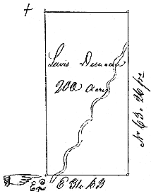
No. 666. Returned 11th June 1808 ~ Warrant No. 382 for 200 acres has this day been applied and Entry No. 248 dated June 22d. 1811 corresponding with the within Survey according to Law ~
State of Tennessee 2nd District ~ At the request and upon the application of Lewis Duncan I have Surveyed for him Two hundred acres of land which is Situate lying and being the county of Warren on the South side of Barren fork of Caney fork. Beginning on a post Oak on the West side of a branch and and about 50 yards from the South West corner of his field running thence East thirty one Chains and sixty three links to a post Oak among post Oaks thence North sixty three Chains and twenty six links to a Mulberry just in the bank of the barren fork thence West along the bank thirty one Chains and sixty three links to a Post Oak thence [should be S.63C.& 26L.] to the Beginning Including his improvement which is truly represented in the annexed plat and was Surveyed the 22nd day of May One thousand eight hundred and eight by ~
Patrick Mac Eachern D.S.
Charles Dement &
Wm Duncan C. C.
Lewis Duncan ~ Marker
Examined & correctness Ascertained
Transmitted to Register 25th Nov 1814 by Thos. Hopkins
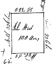
No. 667. Returned 11th June 1808 ~
State of Tennessee Second District ~ At the request and upon the application of John West I have Surveyed for him One hundred acres of land in Warren County Situate lying and being on the South West side of Barren fork of Caney fork Beginning on a black Oak by two black Oaks & post Oak running thence South 35 Chains to a Stake by the side of a branch in an open pond or forearm thence West 28..58 links to a black Oak thence North thirty five Chains to a Stake by two Post Oaks thence [should be E28C.& 58L.] to the beginning Including his improvement May 22nd 1808 which is truly represented in the annexed plat and was Surveyed the day and Year above
Written by ~
Patrick Mac Eachern D.S.
Lewis Duncan &
John West C. C.
Examined & Correctness ascertained
No. 668. Returned 11th June 1808 ~
State of Tennessee Second District ~ At the request and upon the application of Thomas Davis I have Surveyed for him two hundred and forty five acres of land which is Situate and being in the County of Warren and on both sides of the head Spring of Duck river ~ Beginning on a white Oak West of Berries corner about fifteen poles [missing word here?] running thence East thirty five chains to a Post Oak thence North seventy chains to a post Oak thence West thirty five Chains to a black Oak thence South seventy chains to the beginning Including the improvement of said Thomas Moony conveyed to said Thomas Davis which is truly represented in the annexed plat and was Surveyed the 7th of June One thousand eight hundred and eight by ~
Patrick Mac Eachern D.S.
Thomas Bradshaw &
William Davis C. C.
Thomas Davis ~ Marker
Examined & Correctness ascertained
No. 669. Returned 11th June 1808 ~
State of Tennessee Second District ~ By Virtue of an entry No.135 dated the 31st day of August 1807 founded on Warrant No.1711 for 5000 acres I have Surveyed for Jesse Thompson assignee of David Ross One hundred acres of land part of the above Warrant in the County of Warren and on the Waters of the East fork of Stones River Range No 8, Section No 8, his occupant claim including the horse Spring which claim was assigned to him by Wm. Goatcher, Samuel Goatcher and James Gotcher Beginning on a black Locust running thence North twenty five chains to a Gum in the Edge of the ridge thence West forty chains to a Elm thence South twenty five Chains to a Stake thence East forty Chains to the beginning including his improvement which is truly represented in the annexed plat and was Surveyed the 10th June One thousand eight hundred and eight ~
Patrick Mac Eachern __
John Pettis &
Micajah Pettis C. C.
Jesse Thompson Marker
Examined & Correctness ascertained
Transmitted to Register Sept. 15th 1812 by J. B. Hogg
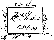
No. 670. Returned 11th June 1808 ~
State of Tennessee 2nd Dist. ~ At the request and upon the application of William Guist I have Surveyed for him One hundred and twenty acres in the County of Warren and on the Waters of Hickory Creek Beginning on a Hickory on the South side of his improvement running thence West forty Chains to a post Oak thence North thirty chains to a Hickory by an Ash thence East forty chains to a Stake in an open barren thence South thirty chains to a to the beginning including his improvement which is truly represented in the annexed plat and was Surveyed the 31st day of May One thousand eight hundred and eight by ~
Patrick McEachern D.S.
Wm. Barnett &
Thos. Roseberry C. C.
Wm. Guist Marker
Examined & Correctness ascertained
Transmitted to Register May 6th 1811
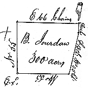
No. 671. Returned 11th June 1808 ~
State of Tennessee 2nd District ~ At the request and upon the application of Britain Jourdan I have Surveyed for him three hundred acres of land which is Situate lying and being in the County of Warren and joining the Cumberland Mountain Beginning on a large Poplar William Gists Beginning corner of 300 acres running thence South Ten Chains to an Ash by an Ash in the Edge of precipice in the Mountain thence South thirteen Degrees West forty five chains to a Stake among Dogwood near Mohinders Conditional line in the edge of the Mountain thence West fifty five Chains to a post Oak amongst black Oaks thence North fifty five Chains to a Gum Gists corner thence East sixty six Chains to the beginning including his improvement which is truly represented in the annexed plat and was Surveyed the 4th day of June one thousand eight hundred and eight by ~
Patrick Mac Eachern D.S.
Wm. Guist &
Andrew Hogg, C. C.
Britain Jourdan Marker
Examined correctness ascertained & Recorded
End of Book 25 { B }. ~ No. 1035 is last on this roll.