The plats and surveys on this page were extracted from the Book 25 { B }, Plats and Surveys, 2nd Surveyors District, 1808. There are 414 surveys in that book. Of that number, 35 can be identified as being of older and greater Warren County. The small Plat graphics were made from photocopies which were made from the microfilm of the original Plats. Hence the generally poor quality of the graphics. Original spelling and punctuation were closely followed in this transcription.
Surveys numbered 654 and higher will be found on Part II.
The names of the applicant for survey are:
William Alexander, No. 663
William Barnett, No. 651
Spencer Beavers, No. 654
Henry Bray, No. 648
Anthony Chamness, No. 657
Thomas Davis, No. 642
Thomas Davis, No. 668
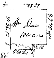
William Davis, No. 640
Charles Dement, No. 665
Jacob Derryberry, No. 659
Michael Derryberry, Jun., No. 656
William Douglass, No. 649
Lewis Duncan, No. 666
Owen Evans, No. 653
William Gist, No. 650
William Guist, No. 670
John Hall, No. 645
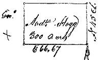
Andrew Hogg, No. 639
James Howell, No. 641
Britain Jourdan, No. 671
Jeremiah Lakey, No. 655
John Looney, No. 660
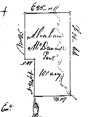
Abraham MacDannell, Jurn., No. 638
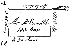
Abraham McDannall, Senr., No. 637
Edward McDannall, No. 647
David McElivee, No. 652
William Morton, No. 644
Alsey Pulham, No. 658
Asael Ranes [Rains], No. 661
William Ranes [Rains], No. 662
Larkin Rogers, No. 646
William Smith, No. 643
Jesse Thompson, No. 669
John West, No. 667
John Woodward, No. 664
Click Here
Some Surveys Extracted From
Tennessee Land Records, Record Group 50,
Microfilm Number 31.
Extracted from Book 25 { B }, Plats and Surveys,
2nd Surveyor's District, 1808, No. 621 to No. 1035.
No. 637.
Returned 11th June 1808. Part of a Warrant No. 1607 for 1600 acres has this day been applied and entry, made corresponding with the within survey and agreeably to the requirements of the 36th Section of the Land Law of 1807 ~ Dec. 16th 1808 ~
State of Tennessee Second District ~ At the request of Abraham McDannall Senr. I have Surveyed for him one hundred acres of land which is Situate lying and being in the County of Warren and both sides North fork of Barren fork of Caney fork. Beginning on a White Oak on the face of a hill and on the South side of a branch running thence North twenty chs and sixty four links to a Post Oak by two Post Oaks, thence West five chains to a White Oak thence North twenty five chains to a Poplar in a marsh thence Et. 25 chains to a White Oak by Black Oak thence South forty five chains & sixty four lks to a Sycamore in an Island in said fork thence West twenty chains to the beginning which is truly represented in the annexed plat and was Surveyed the 25th day of May One thousand eight hundred and eight by ~
Patrick Mac Eachern D.S.
Wm. Davis &
Abrm. Morgan, C. C.
Examined & Correctness Ascertained.
W. P. Anderson, Pn. Surveyor
Transmitted to the Register 16th Dec. 1807
No. 638. Returned 11th June 1808 ~
State of Tennessee Second Dist ~ At the request and upon the application of Abraham MacDannell Jurn. I have Surveyed for him One hundred acres of land in the County of Warren and on both sides of Middle fork of Barren fork of Caney fork of Cumberland River. Beginning on a black Oak on the side of a hill running thence West forty chains to a post Oak by a Post Oak thence South twenty five chains to a Black Oak thence East forty Chains to a black oak in Chamness's line thence with it and passing his corner N 25 chains to the beginning including his improvement which is truly represented in the annexed plat and was Surveyed the 27th May 1808 by ~
Patrick Mac Eachern D.S.
Michael Derryberry &
Wm. Smith, C. C.
Wm. McDannell.~ Marker
Examined & Correctness Ascertained.
W. P. Anderson Pn. Surveyor
No. 639. Returned 11th June 1808 ~
State of Tennessee 2nd District ~ At the request and upon the application of Andrew Hogg, I have Surveyed for him three hundred acres of land which is Situate lying and being in the County of Warren and joining the Cumberland Mountain Beginning on a black Gum in the Edge of the Mountain about 29 poles Et. of the Dividing line of Thomas Wades 20000 Acre tract running thence No. forty five chains to a Stake between two small Hickories thence West Sixty Six Chains and Sixty Seven links to a Hickory thence South forty five chains to a large black Walnut near the Edge of the Mountain thence East Sixty Six Chains and Sixty Seven links to the beginning including his improvement which is truly represented in the annexed plat and was Surveyed the 6th day of June One thousand eight hundred and eight by ~
Patrick McEachern D.S.
Wm. Douglass &
Jas. Howell, C. C.
Andrew Hogg Marker
Examined and correctness ascertained.
W. P. Anderson Pn. Surveyor
No. 640. Returned 11th June 1808 ~
State of Tennessee Second District ~ At the request and upon the application of William Davis I Surveyed for him One hundred acres of land which is Situate lying and being in the County of Warren and on the North fork of Barren fork. Beginning on a Sourwood thence three chains South of the Section line running thence East twenty chains to a Stake in the bank of the Creek thence North four chains and fifty links to a black Oak thence East thirteen chains to a black Oak thence North thirty one chains and Sixty three links to a Post Oak thence West thirty three chains to a Stake in Abraham MacDannell's line, thence South thirty six chains and thirteen links with said line to the Beginning including his improvement which is truly represented in the annexed plat and was Surveyed the 25th day of May One thousand eight hundred and eight ~
Patrick Mac Eachern D.S.
Abraham Morgan &
Edward Bray, C. C.
Wm. Davis ~ Marker
Examined & Correctness Ascertained.
W. P. Anderson, Pn. Surveyor
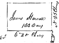
No. 641. Returned 11th June 1808 ~
State of Tennessee Second Dist ~ At the request and upon the application of James Howell I have Surveyed for him One hundred acres of land which is Situate lying and being in the County of Warren. Beginning on a Post Oak running thence North twenty five chains to a Stake by a Chestnut & Hickory near Kinchen Matthew's corner thence West forty chains to an Ash by two Dogwoods thence South twenty five Chains to a Stake between black Oak and Hickory thence East forty chains to the beginning including his improvement which is truly represented in the annexed plat and was Surveyed the 6th day of June 1808 ~
Patrick Mac Eachern D.S.
Wm. Douglass &
Andrw. Hogg, C. C.
James Howell ~ Marker
Examined & Correctness Ascertained.
W. P. Anderson Pn Surveyor[NOTE: Tract probably east of Morrison, near Hickory Creek.]
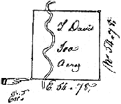
No. 642. Returned 11th June 1808 ~
State of Tennessee Second District ~ At the request and at the application of Thomas Davis I have Surveyed for him three hundred acres of land which is Situate lying and being in the County of Warren and on both sides of Duck river Beginning on a black Oak about 40 poles West of the river running thence East fifty four chains and Seventy eight links to a Stake by a red oak thence North fifty four chains and Seventy eight links to a Stake by 2 post Oaks thence West fifty four chains and Seventy eight links to a red Oak saplin in an open barren thence South fifty four chains and Seventy eight links to the beginning including his improvement which is truly represented in the annexed plan and was Surveyed the 7th day of June One thousand eight hundred and eight by ~
Patrick Mac Eachern D.S.
Thomas Bradshaw &
William Davis. C. C.
Wm. Morton Marker
Examined & Correctness Ascertained.
W. P. Anderson, Pr. Surveyor
No. 643. Returned 11th June 1808 ~
State of Tennessee Second District.~ By Virtue of an entry No.134 dated 31st day of August 1807 founded on a Military Warrant No.2978 for 640 acres issued for the heirs of John Colchester to Thomas Dillon by the Secretary of North Carolina 12th June 1807 I have Surveyed for William Smith assignee of Joseph Terry of Thomas Dillon, One hundred and fifty acres of land part there of leave_ a balance of three hundred and ninety acres yet unsatisfied, which is Situate in White County ninth range and 6th Section in the center of a Square including his improvement, Beginning at a double post Oak which stands South 30_ West 720 poles from the North East corner from the said 6th Section thence East nineteen ____ [chains] and thirty six links to a post Oak thence South thirty eight chains and seventy three links to a Post Oak by a post Oak thence West thirty eight chains & Seventy three links to a Hickory thence North thirty eight chains and Seventy three links to a Post Oak thence East 19 chs. & 37 links to the beginning which is truly represented in the annex plat and was Surveyed the 28th day of May One thousand eight hundred and eight ~
Patrick Mac Eachern D.S.
Anthoney Chamness &
Peter Maricle, C. C.
Wm. Smith ~ Marker
Examined correctness ascertained & Recorded.
W. P. Anderson, Pn Surveyor
Transmitted to Registers Office, July 3rd 1809[ NOTE: Probably near West Fork of Hickory Creek , near Morrison , Warren County.]
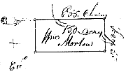
No. 644. Returned 11th June 1808 ~
State of Tennessee Second District ~ At the request and upon the application of William Morton I have Surveyed for him One hundred and fifty acres of land which is Situate lying and being in the County of Warren and on both sides of a prong of Duck River Beginning on a White Oak So. E. of the Indian Mount running thence East fifty five chains to a Dogwood thence South twenty seven chains & fifty links to a Post Oak thence West fifty five chains to a Stake among post Oaks in the barrens thence North twenty seven chains and fifty links to the beginning including his improvements which is truly represented in the annexed plat and was Surveyed the 7th day of June one thousand eight hundred and eight ~
Patrick Mac Eachern D.S.
John Hall &
Edward Moore, C. C.
Wm. Morton Marker
Examined & correctness ascertained.
W. P. Anderson, Pr. Surveyor
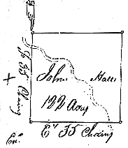
No. 645. Returned 11th June 1808 ~
State of Tennessee 2nd District ~ At the request and uppon the application of John Hall I have Surveyed for him One hundred and twenty acres of land which is Situate lying & being in the County of Warren and on both sides of Duck River Beginning on a black Oak about 24 poles East of Bradshaws corner of his occupant claim of 200 acres running thence South thirty five chains to a Hickory by two White Oaks thence East thirty five chains to a Post Oak by two red Oaks about 3 poles East of the Nicajack trace thence North thirty five chains to a Stake in Bradshaws line thence Wt. thirty five chains to the beginning including his improvement which is truly represented in the annexed plat and was Surveyed the 8th day of June 1808 ~
Patrick Mac Eachern D.S.
Wm. Morton &
Edwd. Moore, C. C.
John Hall Marker
Examined & Correctness ascertained.
W. P. Anderson, Pr. Surveyor
No. 646. Returned 11th June 1808 ~
State of Tennessee Second District.~ At the request and upon the application of Larkin Rogers I have Surveyed for him two hundred and twelve and a half acres of land in the County of Warren and on both sides of the barren fork of Caney fork of Cumberland River, Beginning on a post Oak on the South bank thereof, running thence South sixty seven chains and fifty links to a Post Oak, thence West thirty one chains & fifty links to a Maple in the side of a branch the conditional line between him & Chamness thence North sixty seven chains and fifty links to a Post Oak by 2 post oak, thence East thirty one chains & fifty links to the beginning including his improvement which is truly represented in the annexed plat and was Surveyed 28th day of May One thousand eight hundred and eight ~
Patrick Mac Eachern D.S.
John Diving &
William Kelley, C. C.
Larkin Rogers ~ Marker
Examined & Correctness ascertained.
W. P. Anderson, Pn Surveyor
No. 647. No. 647. Returned 11th June 1808. Part of a Warrant No. 1607 for 1600 acres has this day been applied and entry made corresponding with the with survey and agreeably to the requirements of the 36th Section of the Land Law of 1807 ~ Dec._ 1808 ~
State of Tennessee Second Dist.~ At the request and upon the application of Edward McDannall I have Surveyed for him One hundred acres of land in Warren County. Situate lying and being on the North fork of barren fork. Beginning on a Cherry tree on the bank thereof running thence South twenty chains to a black Oak thence West Seven Chains and fifty links to a black Oak thence South twenty five chains to a black Oak between three Sink holes thence E. twenty five chains to and across the river to a stake in an open priarie thence North forty five chains to a stake thence West seventeen chains and fifty links to the beginning which is truly represented in the annexed plat and was Surveyed the 24th day of May, One thousand eight hundred and eight ~
Patrick Mac Eachern D.S.
Philip Rains &
Jeremiah Lakey, C. C.
Edward McDannall.~ Marker
Examined & Correctness Ascertained.W. P. Anderson, Pn. Surveyor
Transmitted to the Register 16th Dec. 1808
No. 648. Returned 11th June 1808 ~
State of Tennessee Second District.~ At the request and upon the application of Henry Bray I have surveyed for him two hundred and fifty acres of land in the county of Warren and on the dry fork of the Barren fork of the Caney fork of Cumberland River. Beginning on a black Oak on the East side thereof running thence North fifty chains to a Post Oak thence West fifty chains to a Post Oak thence South fifty chains to a black Oak thence East fifty Chains to the beginning including his improvement which is truly represented in the annexed plat and Surveyed the 2nd day of June One thousand eight hundred eight by ~
Patrick Mac Eachern D.S.
Henry Bray Jun.
Rich. Bray, C. C.
Henry Bray Sen. ~ Marker
Examined & Correctness Ascertained.
Wm. P. Anderson, Pn. Surveyor
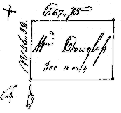
No. 649. Returned 11th June 1808 ~
State of Tennessee Second Dist ~ At the request and upon the application of William Douglass I have Surveyed for him three hundred acres of land which is Situate lying and being in the County of Warren and on the head Waters of Mathew's branch Beginning on a Poplar 10 chains from Gists No.E corner running thence North forty six chains and thirty two links to a Stake by a black Jack in the open Barrens thence East sixty four chains and seventy eight links to a Stake by a Hickory & 2 post Oaks near the main Road which leads to Elk and Flint Rivers thence South forty six chains & thirty two links to a black Oak by a Hickory Wm. Gists 4th corner thence West sixty four chains and seventy eight links to the beginning including his improvement which is truly represented in the annexed plat and was Surveyed the 4th day of June one thousand eight hundred and eight ~
Patrick Mac Eachern D.S. Wm. Gist &
Andrew Hogg, C. C.
Wm. Douglass Marker Examined & Correctness ascertained.
W. P. Anderson Pr. Surveyor
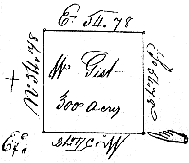
No. 650. Returned 11th June 1808 ~
State of Tennessee 2nd District ~ At the request and upon the application of William Gist I have Surveyed for him three hundred acres of land which is Situate lying and being in the County of Warren and on the head Waters of Mathew's Branch Beginning on a large Poplar just by the Edge of the Cumberland Mountain running thence West fifty four chains & seventy eight links to a Black Gum by a Hickory and Post Oak thence North fifty four chains & seventy eight links to a Poplar by a Hickory & Mulberry thence Et. fifty four chains and seventy eight links to a black Oak thence South fifty four Chains and seventy eight links to the beginning including his improvement which is truly represented in the annexed plat and was Surveyed the 4th day of June One thousand eight hundred and eight by ~
Wm. Douglass &
Andrew Hogg, C. C.
Patrick Mac Eachern D. S. Wm. Gist Marker
Examined and Correctness ascertained.
W. P. Anderson, Pr. Surveyor
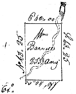
No. 651. Returned 11th June 1808 ~ Part of Certificate No. 438 for 640 Acres was this day applied & entry made No220 dated 3rd August 1810 corresponding With the Within Survey and agreeable to the requistions of the Land Law ~
State of Tennessee Second District ~ At the request and upon the application of William Barnett Esq. I have Surveyed for him two hundred and fifty three acres of land in the County and on both sides of the head _____ [blank] Beginning on a Post Oak running thence South sixty three chains & twenty five links to a post Oak in the side of a small drain thence West forty chains to a Plumb tree by a Mulberry & Ash thence North Sixty three chains & Twenty five links to a Stake in an open barren thence East forty chains to the beginning including his improvement which is truly represented in the annexed plat and was Surveyed the 31st May One thousand eight hundred and eight by ~
Patrick Mac Eachern D.S.
Wm. Guist &
Thos. Williams, C. C.
William Barnett Marker
Examined correctness ascertained & Recorded.
W. P. Anderson, Pr. Surveyor
Transmitted to Register November 21st 1810
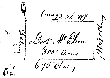
No. 652. Returned 11th June 1808 ~
State of Tennessee Second Dist. At the request and upon the application of David McElivee I have surveyed for him three hundred acres of land in the County of Warren and on the head Waters of Hickory Creek Beginning on a Maple in the head of a large Glade or Priarie running thence South forty chains to a Post Oak thence East seventy five chains to a Post Oak on the East side of said Glade thence North forty chains to a Post Oak thence West seventy five chains to the beginning including his improvement which is truly represented in the annexed plat and was Surveyed the 30th May One thousand eight hundred and eight by ~
Patrick Mac Eachern D.S.
Wm. Guist &
Jacob Miller, C. C.
David McElivee Marker
Examined & Correctness ascertained.
W. P. Anderson, Pr. Surveyor
No. 653. Returned 11th June 1808 ~ Part of Warrant No.247 for 2607 Acres was this day applied & entry made No.196 dated the 7th September 1809 corresponding with the within Survey & agreeable to the requisitions of the Land Law ~
State of Tennessee Second District ~ At the request and upon the application of Owen Evans I have Surveyed for him One hundred and fifty acres of land in the County of Warren and on the head Waters of a branch of Hickory Creek Beginning on a Post Oak running thence East fifty chains to a Stake by a Post Oak thence South thirty chains to a Water Oak thence West fifty chains to a black Oak thence North thirty chains to the beginning including his improvement which is truly represented in the annexed plat and was Surveyed the 30th day of May One thousand eight hundred and eight by ~
Patrick Mac Echern D.S.
David McElivee &
Spencer Bevers, C. C.
Examined correctness ascertained and Record.
W. P. Anderson, Pr. Surveyor
Transmitted to Register Nov 21st 1810
Click Here