
1805-16 Giles County and Surrounding (125K), courtesy TNGenWeb’s Maps Our Ancestors Followed, shows the Cherokee and Chickasaw Indian Land Cessions during this period for both Giles and surrounding TN Counties as well as Northern Alabama, and includes the Congressional Reservation Line and the Chickasaw Boundary Line. See also The Chickasaw and their Cessions.
1816 Giles County and Surrounding (125K): This map, also courtesy Maps Our Ancestors Followed, shows Giles County and Northern Alabama relative to Indian Land Cessions, including the 1816 Chickasaw Cession, with the Congressional Reservation Line and old Chickasaw Line added, as well as corrections to the route of the Natchez Trace (Columbian Highway).
1805-1817 Giles County, TN, Madison Co, MT and Surrounding (90K) This map, also courtesy TNGenWeb’s Maps Our Ancestors Followed, shows Giles Co, TN and Madison and Elk Cos, AL relative to the Mississippi Territory (MT) and Chickasaw and Cherokee boundaries and Congressional Reservation Line.
1817 Giles County and Surrounding This map, courtesy TNGenWeb’s Land of Our Ancestors, shows Giles County relative to Tennessee Survey Districts 2, 7 and 8.
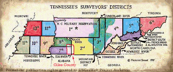
1834 Giles County (19K) This map was extracted from Henry Schenck Tanner’s 1834 U. S. Map (TN), courtesy TNGenWeb’s Maps Our Ancestors Followed
1870-1: The Evolution of Marshall County (41K) This map was created by Gary Wiles for Marshall County, TNGenWeb and shows the Cornersville/Robertson’s Fork area annexed to Marshall from Giles. For those interested in District 17 boundaries, residents, etc., see also Marshall County, TNGenWeb’s 1899 District 17 Map)
1880 Giles County and Surrounding (108K), courtesy TNGenWeb’s Maps Our Ancestors Followed, shows historic towns as well as District 17 (the Cornersville area) that was annexed to Marshall County in 1870/1.
1888 Giles County and Surrounding (88K) This map also shows historic towns as well as the Cornersville area that became part of Marshall County in 1870/1, and was created from a map of 1888 Giles, Maury and Marshall Counties (178K) by TNGenWeb’s Maps Our Ancestors Followed.
1896 Giles County (200K) This map includes historical towns and portions of surrounding counties (both Alabama and Tennessee), and was created by TNGenWeb’s Maps Our Ancestors Followed, from an excerpt from a coal railroad map in the Library of Congress’American Memories Collection