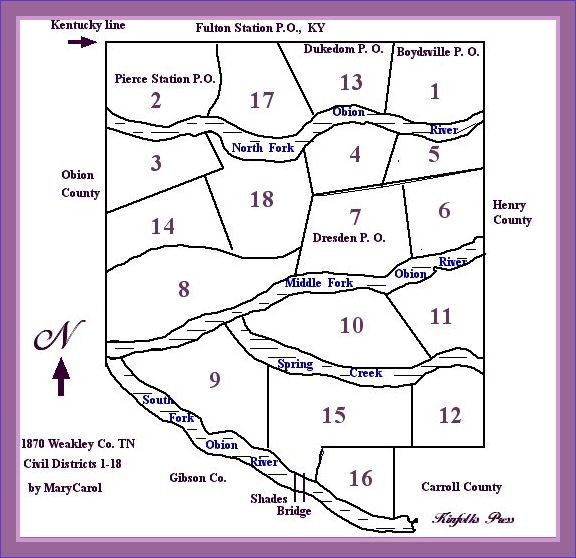
US Census Map of Weakley County Districts 1-18
Looking at new maps and old maps — including the 1880 map by Pansy Nanney Baker and Charlotte Stout Reynolds — I created this simple map on the computer of the 18 Civil Districts plus post offices to give you an idea of where in Weakley County your Kinfolk lived. It is not to scale. District 2 did become part of Obion County in 1870 but not officially until July, 1870. The U.S. Census asked ‘your place of abode on June 1, 1870’ thus District 2 was counted as part of Weakley County.
The Waterways are exaggerated, they played a major role in the making of early Districts. All but one of the Districts borders on either a branch of the Obion River– North Fork, Middle Fork, South Fork or on Spring Creek. It was difficult for people to cross the rivers to get to polling places in the early years, thus the infamous land swap in 1837 between Weakley and Gibson counties along the South Fork of Obion River which switched Davy Crockett’s cabin from Weakley to Gibson county. Can you find the district that does not border on a waterway? It borders a major road of the time, the Dresden-Troy Road. Until 1870 Troy was County seat of Obion County, Dresden still is County seat of Weakley County. County seats were near the middle of Districts for equal access by all. Submitted By MaryCarol