Development of the Iron Industry in the Upper Buffalo River Valley

THE DEVELOPMENT OF THE IRON INDUSTRY
IN THE UPPER BUFFALO RIVER VALLEY

by Edgar D. Byler, III

[Note: This paper was delivered before a joint meeting of the Lewis County Historical Society and the Wayne County Historical Society at Oak Grove Methodist Church, Lewis County, Tennessee, September 10, 1989.]

The history of the development of the iron industry in the upper Buffalo River Valley spans over one hundred years, from about 1816 until the beginning of the Great Depression in 1929. For the purpose of this paper, two particular areas of iron manufacture will be discussed. The first is what was known in the twentieth century as the Napier Iron Works, which traced its origins to a small forge in operation in the 1810’s. The second area of concentration will be the Allen’s Creek furnaces. These furnaces occupy only a short period of the history of the area, but were part of a much larger and grander operation than the Napier Works.

The first iron producing operation on the upper Buffalo was that of John McClish, a Chickasaw Indian. From available records it appears that McClish operated a small forge on either Buffalo River or Chief’s Creek about 1818. This forge was located on property McClish had obtained as part of the Chickasaw Session Treaty of 1816. The treaty granted to McClish and his heirs in perpetuity, 640 acres of land, or one square mile, at the point where the Natchez Road crossed the Buffalo River1.

It is not known what type of forge was in operation at this site. Nor is it known what types of iron or iron products were produced. It is probable that McClish used the forge to make cast products such as kettles and pots, and may have also produced rod or bloomery iron for sale in Natchez and Columbia. The production could not have been great since no reference is made to any mining operations in the area. The ore used by McClish was readily available in large quantities on the top, or near the top, of the ground.2

By 1822, McClish was experiencing financial problems and the sheriff of Lawrence
County, Tennessee sold portions of McClish’s lands to satisfy judgements against it.  It appears that at this time McClish leased his iron works, or the lands on which they stood, to John Jones, David Steel and Thomas Steel. Reference is made in Lawrence County, Tennessee Court minutes of a petition from these men at this time to condemn 3000 acres of worthless and unclaimed land for their iron works located on the southwest corner of McClish’s land. This may have been the “Hed’s Old Works” referred to in 1827.3

The on 3 July 1827, McClish sold 160 acres, which included the “Hed’s Old
Iron Works” to John Catron and John C. McLemore who had earlier bought out the heirs of Jones, and the interest of the Steel’s. McLemore sold his interest to Lucius J. Polk who with John Catron and Catron’s brother, George, entered into a partnership known as the Buffalo Iron Works. George Catron, familiar with iron production, became manager of the works. By 1828, John Catron was the sole owner of the operation. George Catron died in 1828, and Polk sold his interest to John Catron in 1827. At this time Felix Catron became manager of the works.4

The Cantrons managed the Buffalo Iron Works for five years. It is not known whether or not the operations were successful or would have been. The “Biddle Panic” of 1833, brought on by the dissolution of the Bank of the United States by President Andrew Jackson, brought an end to the management of the works by the Catrons. John was forced to sell the works to his son, John Jr, and George F. Napier. They were unable to obtain funding for the purchase due to the unsettled financial conditions and Napier had to get brother, Dr. E. W. Napier, to co-sign the loans from the banks.5

The Buffalo Iron Works were apparently inactive at this point. In 1836, Napier announced that he was going to completely rebuild the works. However, again financial panic closed the operations before the new furnace could be brought into blast. The company underwent several reorganizations and was finally taken over by Dr. E. W. Napier.6

In 1845, Dr. Napier gave his nephew, William C. Napier, one-half interest in the Buffalo Iron Works. At this time, it appears the works had been idle for some time as the younger Napier set about rebuilding the furnace stack and improving the operations. When Dr. E. W. Napier died in 1848, William C. Napier became the sole owner.7 According to J. B. Killebrew, production during this period had been about 20-23 tons of pig per day when in blast.8

The Buffalo Iron Works now became known as the Napier Iron Works. L. G. W. Napier, possible brother of William C., is listed in the 1850 Lawrence County, Tennessee census as iron maker and was probably in charge of the operations.9 The works seems to have continued throughout the 1850’s and into the early 60’s. In 1860, William C. Napier himself was listed in the Lawrence County, Tennessee census as “Iron Monger” and had probably taken direct control of the operations.10

We have no record of the activity of the Napier furnace during the Civil War. The
furnace is prominently marked on the military maps made during the war, but no indication is made as to whether or not the furnace was in use, abandoned or destroyed. Gen. Buell’s army passed by the furnace in April 1862, and Gen. Hood’s army passed the neighborhood in November 1864. Neither makes any reference to the operations.

At this point the furnaces were located in Lawrence County, Tennessee as a result of the repeal of the act creating Lewis County. Maps of the period show the iron works to be on the south side of Buffalo River.11

Following the war, the furnace seems to have undergone extensive repair and was put back into operation. The following excerpt from Tennessee’s Western Highland Rim Iron Industry, complied by Samuel D. Smith, Charles P. Stripling and James M. Brannon in 1988, gives a description of the furnaces at Napier.

The furnace is reported to have been again repaired in 1873, and at that time the single stack was 33 feet high by 9 feet across at the bosh, dimensions suggesting an old-style furnace stack. The forge was refitted in 1879-80, and consisted of a water powered operation with four fires and two hammers, with an annual capacity of 600 net tons of charcoal blooms.12

During the 1870’s the works appear to have been leased by Napier to other operators. Although later reports indicate that during the 1880’s the furnace and forge were abandoned or inoperative. In 1885, all the Napier Furnace lands were included inside the boundaries of Lewis County.13 By 1891, the company was again reorganized and the new owners, E. C. Lewis and J. Hill Eakin, under the name, Napier Iron Works, built a new furnace.14

In 1891, a new stack 60 feet high by 12 feet across at the bosh was built and was put into blast in February 1892. This is evidently the furnace located about one-half mile northwest of the original operation. The old hillside furnace was permanently abandoned at this time and the village of Napier was established.15 

During the 1870’s the iron blooms and pigs were carried by wagon to Mt. Pleasant, Tennessee where they were transferred to the railroad for shipment. Several years later, the railroad was extended to Carpenter’s Station and finally in 1894, the Nashville, Florence and Sheffield Railroad was granted a right-of-way through the Napier properties and the line was extended to the furnace.16

The new furnace was remodeled in 1897 to use coke instead of charcoal and operated in this capacity producing foundry pig iron until 1923 when it was blown out for the last time. In 1927, a corporation was formed under the leadership of W. R. Cole, a former company president, but plans for the revitalization of the Napier Iron Works were not realized due to the onset of the Great Depression. The furnace was dismantled about 1930
for salvage material.17

According to Mr. Lindsey, President of the Napier Iron Works in 1912, the Napier
furnace was producing about 100 tons of #2 foundry pig per day.18

—————-

bonair1

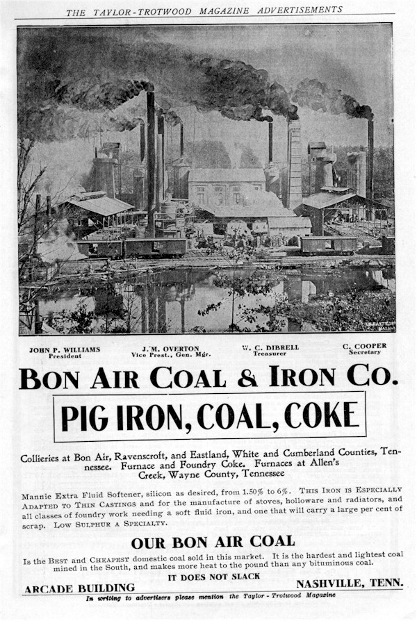
Ad for the Bon Air Coal & Iron Company which appeared in “The Taylor-Trotwood Magazine” February 1907 

The second of the iron furnaces in the upper Buffalo River valley was the Allen’s Creek furnaces. This operation was started in 1891 by the Southern Iron Company as a mining operation. Through the machinations of the Southern Iron Company, the Nashville, Chattanooga and St. Louis Railroad built a trunk line from Shubert in Lewis County, Tennessee to Allens Creek in Wayne County, Tennessee. The main interest at first seems to have been mining ore. But in 1892, construction was begun on two furnaces. These were built from materials and machinery salvaged from two abandoned coke furnaces in west Nashville. Called Mannie #1 and Mannie #2, the #1 furnace was blown in on 22 April 1893.

But before #2 could be brought into blast, the financial panic of 1893 made the company insolvent and operations ceased.19

In 1895, the assets of the Southern Iron Company were bought by the newly established Buffalo Iron Company of Nashville. The new company refurbished Mannie #1 and blew in #2 in 1896.20

During the period from 1892 until 1902, the furnace, when in operation, used charcoal for fuel. At one point, with both #1 and #2 operating, it took two acres of timber a day to furnish charcoal for the furnaces.21 The process was expensive and required many hands to cut the timber, saw it to length for the ovens, fire the ovens and then remove the finished charcoal. A review of the 1900 census for this area reveals that over 50% of the hands were involved in the timber operation.22

In 1902, the Bon Air Coal & Iron Company took over the assets of the Buffalo Iron
Company, which included the assets of the Warner Company in Hickman County, Tennessee.  In exchange for $730,265.94 in preferred capital stock and $730,264.94 in common stock, the Buffalo Iron Company transferred all its assets, contracts, lands and its indebtedness to the Bon Air Coal & Iron Company.23

At this point the furnaces at Allens Creek were changed from charcoal to coke fired furnaces. From an economic standpoint, this was a more profitable arrangement since the Bon Air company owned coal mines at Bon Air, Ravenscroft and Eastland, Tennessee. When necessary they also bought coke from the Virginia coal fields.24

bonair2

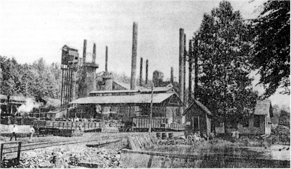
The Mannie furnaces at Allens Creek, 1923. Reproduced from the Tennessee Division of Geology Bulletin 39, Plate 29.

Then in 1917, the Bon Air Coal & Iron Company was reorganized as the Bon Air Coral & Iron Corporation with Mr. William J. Wrigley as chairman of the board, James R. Offield, president, Wm. J. Cummins of Nashville as vice-president, John Bowman, treasurer, and Frederick Leare as secretary. Mr. Wrigley, the principal financier in this reorganization was the founder and president/chairman of the board of Wrigley Chewing Gum Company of Chicago. Bowman, president of the Biltmore Hotel chain in New York was the secondary financier.25

Mr. Wrigley’s perception of the problem with the iron industry was summer up in a letter he wrote to J. H. Patrick of Nashville on 5 August 1918:

Some of your descriptions have caused me to laugh for I know how true they are; especially what you say about the Iron Division. First, they are long on coke and short on iron, and then long on coke and iron and short on limestone; then, they are short on all three.26

Because of his sizable investment in the Bon Air operations, Mr. Wrigley made an
inspection tour of the operations in 1917. He arrived by private railroad car in
Collinwood, Tennessee from Nashville, Mr. W. M. Cummins in tow. While in Collinwood, they toured the Bon Air lands and operations west of the town. Then on the second day of the visit, they drove to Waynesboro where Mr. Wrigley delighted the children on the square by passing out free chewing gum. Returning to Collinwood, there was a grand reception in the evening at the Highland Inn, hosted by the Highland Inn Country Club. The following day, the entourage boarded Mr. Wrigley’s private care for a tour of the Allens Creek and
Lyles, Tennessee operations before returning to Nashville.27

bonair3

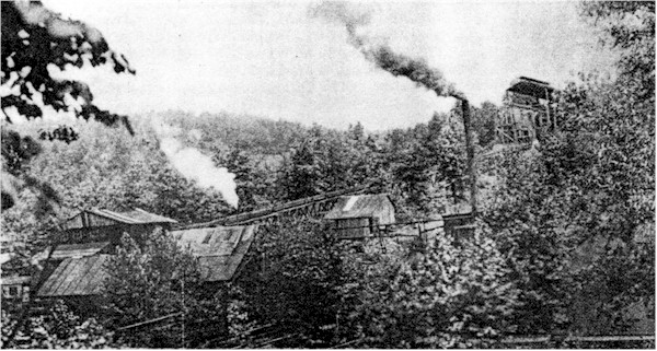
Ore washer at the mines of the Bon Air Coal & Iron Corporation, Allens Creek, Lewis County (formerly Wayne County) Tennessee, 1923. Taken from Tennessee Division of Geology Bulletin 39, Plate 28.

The furnaces at Allens Creek continued intermittent operation until 1923. From 1920 to 1923, only one stack was in blast. The company underwent reorganization in 1920. In an attempt to remain competitive, the corporation induced the state legislature to change the county line between Wayne and Lewis Counties so that the Allens Creek operations were placed in Lewis County. This occurred in 1924. But all attempts at revitalization failed; the furnaces were dismantled in 1926 and sold for scrap iron.28

The biggest problem associated with the iron industry in the Buffalo River valley, as well as elsewhere on the Western Highland Rim, was the lack of capital to finance the operations. To build and operate the furnaces required large amounts of money which was not always readily available. Prior to the Civil War, the only means of obtaining this capital was in loans from banking institutions and in partnerships of monied people. The limited liability stock company had not generally come into use prior to the war.

This practice of partnerships and loans was fraught with problems. Frequent financial panics forced calls on loans and often forced the dissolution of the partnerships. Each time the iron works were the first to feel the effects of the panics.

The Civil War practically destroyed the industry in the Western Highland Rim. Prior to the war, much of the labor had been supplied by slaves, usually leased from the planters or their estates. The war and the subsequent emancipation of the slaves, eliminated a pool of cheap labor. Attempts to rebuild following the war were often met with further economic setbacks. The Panic of 1873 for example resulted in a four-year long depression which wiped out most of the operations.

Another problem facing the iron producers in the upper Buffalo River valley was
transportation. Prior to the 1890’s their ores had to be hauled to the furnace or forge site by wagons; the finished product, either pigs or blooms, had to be hauled, again by wagon, to either the railhead at Mt. Pleasant, Tennessee or to the nearest river port, Clifton, Tennessee. The building of the spur lines from Summertown to Napier and from Centerville to Allens Creek eliminated most of the transportation problems. But it was simply too late; by this time, the rich ore fields in Minnesota and Wisconsin had eliminated the need for the poorer quality iron produced at Allens Creek and Napier.

There is little doubt that the iron industry play a significant role in the development of the upper Buffalo River valley. There is also little doubt that financial instability and the availability of higher grade ores spelled doom for the iron industry in the upper Buffalo River valley.

____________________

Footnotes:

1. Phelps, Dawson, “Stands and Travel Accommodations On The Natchez Trace”,
unpublished. manuscript, Natchez Trace Library, Tupelo, MS, p. 53.

2. Carpenter, Viola H., “Some Lawrence County Iron Mongers And Their Mines.” Yesterday
and Today In Lawrence County, [Tennessee]
, Volume VII, Issue 3.

3. Ibid.

4. Ibid.

5. Smith, Samuel D., et al, A Cultural Resource Survey Of Tennessee’s Western
Highland Rim Iron Industry, 1790’s – 1930’s
, Tennessee Department of Conservation,
Division of Archaeology, Research Series #8, 1988, pp. 88-89.

6. Carpenter

7. Ibid.

8. Smith, page 88.

9. Carter, Maymaud & Joan C. Hudgins, 1850 Census of Lawrence County, Tennessee,
page 105.

10. Warren, Polly C., Lawrence County, Tennessee 1840, 1860 Census, Private Acts and
Miscellaneous Newspaper Extracts
, P-Vine Press, n.d., p. 86.

11. Map, Army of the Cumberland, US Army, Corps of Engineers, 1863.

12. Smith, p. 89.

13. Whitney, Henry D., comp., ed., The Land Laws of Tennessee, Chattnooga, J. M.
Deardorff & Sons, 1891, p.954.

14. Smith, p. 89

15. Ibid.

16. Purdue, A. H., The Iron Industry Of Lawrence and Wayne Counties, Tennessee”, The
Resources Of Tennessee
, Volume 2, Number 10, October 1912, pp. 375-376.

17. Smith, p. 89.

18. Purdue, p. 375.

19.Miser,Hugh D., Mineral Resources Of The Waynesboro Quadrangle, Tennessee,
State Geological Survey, Bulletin #26, 1921,p. 46.

20. Ibid.

21. Ibid.

22. Scott, Alf & June, Census Records of Wayne County, Tennessee, Volume
5:1900, pp. 123-148.

23. Buffalo Iron Company to Bon Air Coal & Iron Company, Deed, 5 August 1902, Wayne
County, Tennessee Deed Record, Book Y, pp. 124-215.

24. Miser, p. 46.

25. Wrigley, Wm. F., Jr. private correspondence, Wm. F. Wrigley, Jr. Company Archives,
Chicago, Illinois.

26. Wrigley, Wm. F. Jr. to J. H. Patrick, personal correspondence, 5 August 1918.

27. Lawrenceburg, Tennessee “Democrat”, 17 June 1917.

28. Smith, p. 88.


SOURCES:

Anonymus, “From The Collinwood Pilot,” Democrat, 17 June 1917,
Lawrenceburg, Tennessee.

Carpenter, Viola H., “Some Lawrence County Iron Mongers And Their Mines,” Yesterday
and Today in Lawrence County [Tennessee{
, Volume Vii, Issue 3.

Carter, Marymaud K., & Joan C. Hudgins, 1850 Census of Lawrence County,
Tennessee
, privately printed, Lawrenceburg, Tennessee, n.d.

Miser, Hugh D., Mineral Resources Of The Waynesboro Quadrangle, Tennessee, State
of Tennessee, State Geological Survey, Bulletin 26, Williams, Nashville, 1921.

Phelps, Dawson, “Stands and Travel Accommodations On The Natchez Trace”,
unpublished manuscript, Natchez Trace Parkway Library, Tupelo, MS, n.d.

Purdue, A. H. “The Iron Industry of Lawrence and Wayne Counties, Tennessee,” The
Resources of Tennessee
, Volume 2, Number 10, October 1912. Tennessee Geological
Survey, Nashville, Tennessee.

Scott, Alf & June, Wayne County, Tennessee Census Records, Volume 5: 1900,
The Byler Press, Collinwood, Tennessee 1988.

Smith, Samuel D., Charles P. Stripling, and James M. Brannon, A Cultural Resource
Survey of Tennessee’s Western Highland Rim Iron Industry 1790’s – 1930’s
,
Tennessee Department of Conservation, Division of Archaeology, Research Series #8, 1988.

U.S. Army Corps of Engineers, Map – Army of the Cumberland, 1863, US Archives,
Washington, DC, unpublished.

Warren, Polly C., Lawrence County, Tennessee 1840 Census, 1860 Census, Private Acts,
Miscellaneous Newspaper Abstracts
, P-Vine Press, Columbia, TN, n.d.

Wayne County, Tennessee Deed Records, Book Y, Wayne County Courthouse,
Waynesboro, Tennessee.

Whitney, Henry D., comp., ed. The Land Laws Of Tennessee, Chattanooga, J. M.
Deardorff & Sons, 1891.

Wrigley, William F., Jr., Private Correspondence, William F. Wrigley, Jr. Company
Archives, Chicago, Illinois.

Introduction To The Resources Of Tennessee

NOTE: Originally published in 1874, and commonly referenced as Killebrew, this volume of data and statistics about the resources of Tennessee provides a large picture window into the state of industry in Tennessee from the founding of the state in 1796 until 1874. The chapter on Wayne County is reproduced here, from the original book, courtesy of Mr. Jerry MOORE who donated a copy of the volume to the Office of the County Historian.

Bibliography: KILLEBREW, J. B., assisted by J. M. SAFFORD, Introduction to the Resources of Tennessee, Nashville, Tenn. Tavel, Eastman & Howell, Printers to the State, 1874.

The Wayne County chapter begins on page 971and concludes on page 979.


WAYNE COUNTY

County Seat — Waynesboro

The act establishing Wayne county was passed November 24, 1817. More than half of the present county of Hardin was originally embraced within the territory of Wayne. Be the creation of Hardin, Wayne was shorn of its most fertile lands; its river front being reduced to about ten or twelve miles.

Topography, Extent, etc. Wayne County is situated on the extreme western side of the Highland Rim, with its north-western corner projecting into the western valley of the Tennessee. It contains about 700 square miles. The county is bounded on the north by Perry and Lewis, on the east by Lewis and Lawrence, on the south by the State of Alabama, and on the west by Hardin county and the Tennessee River. It is a high elevated plateau, between eight hundred and a thousand feet above the sea, furrowed by deep winding ravines or “hollows” , with intervenient high rolling ridges, cur transversely in places by other ravines, which give the surface of the county the appearance of what sailors call a “chopped sea”. Generally, however, these ridges radiate from the center of the county in every direction, except toward the east, in which direction the lands are flat, level and barren.

Streams. As might be inferred from the broken surface of the county, the number of water courses is very great, and the high elevation of the county above the Tennessee River gives them a rapid fall. After heavy rains these creeks rise with startling rapidity, and run down almost as rapidly as they rise. Indian Creek, noted for its wide bottoms and good farming lands, rises in the eastern part of the county and runs west, passes through Hardin and empties into the Tennessee River below Satillo. This creek has numerous tributaries which branch out as son ascends the stream until they resemble the numerous limbs of a pictured tree. Many good mill sites are found upon these branches, though the quantity of water is variable, and cannot be relied upon throughout the year. Hardin Creek rises in the south-east part of the county, and running west, empties into the Tennessee River, a short distance above Clifton. It has two or three good un-improved mill sites upon it. Mill Creek, a tributary of the last, is an excellent stream for milling purposes. The stream, in many places, has cut down through a solid ledge of rocks, so that the banks are firm and durable. Butlers’ Creek, a tributary of Shoal Creek, runs southeast through a rich portion of the county. This stream has a rapid call, good limestone banks and a fine lay of land upon the banks for the building of mills and factories. Big Cypress, Middle Cypress and Little Cypress all rise in the south-eastern portion of the county, run south, and after their confluence, empty into Shoal [editor’s note: obviously Killabrew did not pay close attention to the map of Wayne County. This paragraph is full of obvious errors. The Cypress Creeks don’t empty into Shoals Creek, but rather into the Tennessee River just west of Florence, Alabama. And Hardin Creek does not rise in the southeastern part of the county. So the reader is warned to use this material with great caution – edby3] There are already erected several good mills on these streams. Second creek rises in the south-east corner [that’s interesting, I thought it had its beginning in the south-western quarter of the county], runs south-west and empties into the Tennessee River at Waterloo. This stream could be readily utilized as a water-power. Factory’s Fork rises in the east part of the county, runs south-east and empties into Shoal Creek. It is a good water-power. Forty-eight Creek rises in the north-eastern part of the county, runs north-west and empties into Buffalo. It is a good stream for mills, and upon its banks before the was there was a forge of the same name. Green River rises in the south-eastern part of the county, runs north and empties into Buffalo. It is very rapid in its fall, and has some good mill sites. Moccasin Creek, a tributary of Buffalo, rises in the northern part of the county, and runs north. It is a short, swift stream, but is constant in its supply of water, and is an admirable milling stream. Buffalo River enters the county from the north-east, and after running west half way across the county, makes a right angle and passes out north through Perry County. It is a tributary of Duck River, is very rapid in its fall, but the banks are not usually good for the erection of mills and factories. It is bountifully stocked with game fish. Rock House rises in Lewis county, and running a short distance through the north-east corner of Wayne, empties into Buffalo. It has no great excellencies. Opossum is a small stream that rises in Lewis county and empties into Buffalo. It has an excellent mill site. Mill Creek, a tributary of Buffalo, rises in Lewis county. It has good substantial banks, a rapid descent, and has much available water-power. Chapel Creek, also a tributary of Buffalo, enters that stream near Flatwoods. It drives an excellent flouring-mill, also gin and saw-mill. The supply of water is small during the summer. Beech Creek rises two miles west of Waynesborough, runs west and empties into the Tennessee River. It has one mill and several good mill sites. Eagle Creek rises six miles west of Waynesboro, runs west and empties into Hardin’s Creek, three miles from Clifton. It is worthless as a water-power, the banks being low, changeable, and the supply of water very variable. The low bottoms supply many convenient sites for tanyards, of which there are several on this stream.

Lands and Soils. The lands in Wayne county may be divided into three classes, viz: mineral, agricultural and grazing. Of the first class there are more than 200 square miles, lying in the eastern and south-eastern parts of the county. These lands usually have a rolling surface, are well supplied with timber, except in those spots where it has been consumed in the manufacture of charcoal. The soil upon these mineral lands is exceedingly sterile. The humus is a thing wafer that is lost when brought into tillage by the superabundance of gravel and yellowish clay. The gravel upon the highest hills is often waterworn, sometimes angular, but always indicative of an unproductive and stingy soil. The characteristic growth, besides the timber, is greenbrier, persimmon bushes and a grayish moss, upon which the wild deer subsist during the winter. This rolling land is sometimes deeply cut by streams, upon the banks of which are found exposed limestone, siliceous and black shale, and occasionally hydraulic rock. The agricultural lands are mostly confined to the river and creek bottoms. They are heavily charged with a black, flinty, angular rock; soil alluvial and highly productive of wheat, corn, cotton, peanuts, sorghum and hay. The best bottom lands will make per acre thirty bushels of corn, twenty bushels of wheat, 1,200 pounds of seed cotton, fifty bushels of peanuts, and from two to three tons of hay. Instances are given where four tons of German millet have been raised to the acre. Clover would grow with an abounding luxuriance upon the bottom lands, but the habit of sowing clover has not yet been adopted by many of the farmers. The objection to raising perennial grasses is, that the broomsedge soon destroyed the meadows, and it has been found in practice impossible to keep out. These lands command very high prices, ranging from $20 to $50 per acre, according to improvement and location. Scarcity, too, makes this quality of land in demand. It may be stated that the fertility of the soil adjoining these bottoms reaches high up on the hills on the south side of the streams, and but for the tendency of such hill-sides to wash, they would be almost as valuable as the bottoms themselves. The south sides of the ridges are poor. It would be a mistake to infer tat the north sides of all the ridges are fertile. The fertility is only confined to such ridges as bound the water courses. Away from these and on the south sides of the dry “hollows” the soil is almost as thin as on the north sides. On the waters of Buffalo River, Indian Creek, and a portion of Beech Creek, the bottoms are wide, the farms good, the improvements respectable, while on Hardin’s Creek, Butler’s Creek, Second Creek, Factory’s Creek, Forty-eight Creek, Green River, Moccasin, Opossum, Chapel and Eagles Creeks, the bottoms are narrow, farms small and improvements common. On the Cypress the bottoms attain a width of half a mile, and many productive farms are found upon that stream. It is estimated that the lowlands of the county will cover 70 square miles, or 44,800 acres. The third class of land, which is put down as grazing land, is flat and open, covered during the summer with a rank wild grass, which supplies nearly all the food for the stock (other than work stock) in the county for eight and ten months in the year. The usual practice with farmers is to begin to feed about the middle of December, and to stop the first of April, or so soon as the buds and young grass appear. But little of this flat land is cleared for the purpose of cultivation. Here and there a spot with a rich red clay subsoil may be found that will yield remunerative crops, but wherever the subsoil is white or bluish in color, the land is cold and unprofitable for general cultivation. Fruits, however, yield abundantly on such lands, and the trees are long-lived, hardy and not subject to disease. Old, abandoned homesteads on such lands, of which there are many on the road leading from Waynesboro to Columbia, show the fruit trees vigorous and healthful. Some of these tress, peach and apples, are known to have been set out fifty years ago, and they are still fruitful. The high elevation of this barren land, its healthfulness and cheapness, may cause it in time to become one of the great fruit-growing regions of the state. The people of the county are turning their attention to fruit-growing, many orchards of choice fruit having been set out during the past two years.

Stock. Sheep husbandry could be made a profitable business but for the grand army of curs that roam over the country. Twenty-five per cent of sheep killed annually is the least estimate put down by any one. Many are deterred from sheep and wool-growing on this account. The wild, savannah-like surfaces that cover a large portion of the county, the sheltering hill and the genial climate, all point to Wayne as being well adapted to sheep-growing. A few fine Berkshires introduced by some enterprising citizens several years since, have greatly improved the breed of hogs. But little pains are taken with the hog. Subsisted in the woods upon the mast from September to June, and then upon the wild grasses, this animal is scarcely domesticated. Pork enough is raised to supply the demands of the county, but very little for export. The cattle are principally “scrub”. Some of them make good milkers. A few Short-horns are being introduced, and the quality of the cattle is gradually improving. Before the war mules were raised for the southern markets, but the destruction of the breeding animals was so great during the period of hostilities that the farmers have only been able since to raise enough for the home demand.

Timber. Very few counties in the State are more abundantly supplied with timber. The southern part is covered with a dense forest of yellow pine, which has scarcely been touched. On the ridges, white oak, black oak, chestnut, poplar and chestnut oak prevail. Cedar timber of a good quality covered the glady hills near Clifton, but most of it has been cut down. The white oak timber is largely consumed in the manufacture of pipe staves for the French and Spanish markets, and near the Tennessee River it is growing scarce and dear. Seventy-five thousand staves are annually shipped from the county, and as the demand continues to increase, the vast white oak forest of the interior will be rapidly consumed in meeting this demand. The tanbark from the chestnut oak is largely used in the various tanneries, and is found in practice to be the best for tanning purposes. It makes by far the best leather, which brings at least ten cents per pound more than the hemlock or oak-tanned. In he iron regions, the timber is very valuable. Charcoal, of which forty bushels are made from a cord of wood, is the fuel used for smelting purposes. In the neighborhood of Wayne Furnace, timber is consumed at the rate of 700 acres annually. With proper protection by law, the great extent of land denuded of timber could be made to yield a new growth, but the annual burnings destroy all the young sprouts as fast as they appear, so that the old coaling lands are a dreary waste, covered with broomsedge and green briers , and worthless to the owners.

Minerals. Hydraulic rock of an excellent quality has been found near Clifton, underlying a reddish limestone. This red limestone is classed as a marble, and though not equalling the variegated beauty of the East Tennessee Marble, yet some of it makes quite a handsome and durable building stone. But by far the most valuable mineral in Wayne County is the iron ore. This is found in large local deposits called banks, and the quality of the ore is vary variable, some of it being so intermixed with gravel and siliceous and argillaceous material as to be nearly worthless. The best banks yet found are two miles south-east of Wayne Furnace. The ore lies in wave-like masses, running mostly parallel with the surface. But these masses sometimes approach and run into each other and then separate, leaving between large masses of clay and flint. The ore has been dug to a depth of thirty feet with no apparent diminution of quality. Outcrops of iron ore occur upon nearly every hill around the furnace, and these indications extend at places down to the beds of the streams. The gravel overlying the ore is sometimes white and water-worn, but generally of a pale yellowish appearance. Practical iron men consider the quantity of ore inexhaustible. The ore is a brown hematite, and yields from the furnace 44 per cent. Near Clifton is a bed of anhydrous red oxide of iron that is vary valuable. A shaft has been sunk in this bed to the depth of twenty-five feet without reaching the bottom of the ore. Much of this ore is very soft and can easily be reduced to powder and used as a pigment.

Wayne Furnace Thirty-five years ago, two furnaces were erected upon the same ground where Wayne Furnace now stands. One of them was discontinued and the other was kept in blast for many years. Six years ago, the Gaylord Iron and Pipe Company, of Kentucky, bought the property for $40,000, inclusive of 21,000 acres of land, and set to work to repair it. They introduced the hot blast, erected new stacks, and began operations on a scale much more extensive than ever before. The capacity of the furnace was increased to twenty-four tons per day, but it rarely makes above eighteen. The iron manufactured is cold short, and is unfit for boiler plate, car wheels or wrought iron. It is mostly consumed in the foundry owned by the same company in making iron pipe. One hundred and fifty bushels of charcoal are consumed in making one ton of pig iron. The estimated cost of coal at present is six cents per bushels. The cost of green ore delivered at the furnace, $2 per ton, of which two and one-third tons are used to one ton of iron; cost of limestone per ton of iron, fifty cents; labor and salaries, $6.44; incidentals, such as sand, hearth, interest, etc., $1.33; making present cost of a ton of iron $21.97. It costs $5 per ton to get to Clifton, on the Tennessee River, and $3.62 from that point to Cincinnati, making its present (January , 1874) cost in Cincinnati $29.59. It must be remembered, however, that much labor is paid for in goods, upon which a profit of from thirty to fifty per cent. Is made.

About 200 hands are kept in constant employment, and nearly all the work is done by contract. Sixty cents per cord is paid for cutting wood; $2 per ton for digging and delivering ore; daily laborers, $1.20 per day; skilled laborers, $1.60. The furnace force consumes annually 20,000 bushels of corn, 30,000 pounds of bacon, 600 barrels of flour, 1,200 bushels of corn meal, and 360 tons of hay. It may be stated as a significant fact that all the hay and most of the bacon are brought from Indiana and Kentucky. This furnaces furnishes the best market in the county.

The height of the stack of Wayne Furnace is forty-two feet; width across the boshes, eleven feet; hot blast being heated by the waste heat from the trundle head. It is driven in through two tuyers. Capacity of furnace, 5,800 tons annually.

Tanneries. Previous to the war, Wayne county was noted for the number and excellence of its tanneries. More than a dozen were then in operation, manufacturing annually 200,000 pounds of superior leather. Many of them were abandoned or destroyed during the war, and now the number is reduced to four. These manufacture 100,000 pounds of leather annually. The hides are obtained in the St. Louis and New Orleans markets. The leather is mostly shipped to St. Louis. When the abundance of streams that thread the county, and the almost exhaustless quantities of tan-bark, the manufacture of leather will doubtless become in the future one of the leading industries of its citizens. Bark is sometimes shipped, though not in large quantities.

Towns and Villages. Waynesboro, the county seat, was located by commissioners appointed by an act of the Legislature November 5, 1821. The court were removed to that point in the fall of 1823, and since that period, it has been the seat of justice. It is situated on a level plateau on Green River, and has many high hills encircling it. Population 300; dry goods stores 4; saloons 3; hotels 1; churches 2, one of which is a colored church, the other Cumberland Presbyterian. It has also a large tannery, and a school averaging eighty scholars.

Clifton is a flourishing little town of five or six hundred inhabitants situated on the Tennessee River. It has five dry goods stores, two drug stores, two saloons, one saddler’s shop, one hotel, one foundry, one church, Presbyterian, a Masonic school that contains about sixty students, male and female. There are annually shipped from Clifton: 1,200 bales of cotton, 6,000 tons of iron, 3,000 bushels of wheat, 100,000 pounds of leather, 50,000 staves, 7,000 bushels of peanuts, 500 bushels of dried fruit, besides considerable quantities of feathers and lumber. The latter article, delivered on the river bank, is worth from $14 to $15 per thousand feet. Ashland, on Buffalo, has three stores, one grocery, blacksmith shop, and two churches, Southern Methodist and Cumberland Presbyterian. Flatwood, on Buffalo, has two stores, one church, Protestant Methodist. Wayne Furnace has a store, blacksmith shop, and two churches. Martin’s Mill has a store, saw-mill, grist-mill, woolen mill, tanyard, and one church, Cumberland Presbyterian. Parker’s store, on Indian Creek, has two stores, cotton gin, blacksmith sop and tanyard.

The Agricultural and Mechanical Association has erected handsome buildings upon a lot near Waynesboro. The first fair was held in 1872 and another in the fall of 1873. Both were eminently successful. The Association is out of debt, and the people of the county flock in droves to the annual exhibition.

School Statistics. There were enrolled in 1873, between the ages of six and eighteen years, whites, 1,270; colored, 69; total, 1,339. Between the ages of eighteen and twenty-one years, white, 64, colored, 5, total scholastic population, 1,408.

There are employed in the public schools thirty-nine teachers; average salary paid teachers $31.37. Owing to the failure of the magistrates to levy an additional tax for school purposes, the free schools were only kept up for a period of two months and a half.

Statistics. The population of the county in 1870 was as follows: whites, 9,316; colored, 893; total, 10,209. Number of acres of land assessed for taxation in 1873, 422,267; value, $1,243,009; number of town lots, 178; value, $70,901; value of mills, manufactures, etc., $70,238; value of personal property, $278,433; total valuation, $1,664,484. Number polls, 1,452. Amount State tax, $6,650.32; amount county tax, $3,325.16; total tax, $9,975.48

Health. There is no healthier county in the State, as the experiences of physicians show. Being well drained, and but a small portion lying in the Tennessee Valley, there is little or no malaria in Wayne county. Its elevation above the sea gives it a mild and pleasant climate and makes it peculiarly pleasant in the summer.

Immigrants. While the citizens greatly desire to see their county populated with an industrious class of immigrants, they have been unable as yet to attract but few from other States. The want of transportation, schools, and public spirit has deterred many from making Wayne county a permanent home. There are no railroads in the county, and while the citizens would hail with delight any external movement to open up their resources to the world by rail, they are yet averse, many of them, to a levy by the county for that purpose. The word tax has a sound to their ears as ominous as the road that precedes a whirlwind. Taxes, to their minds, are destructive of the best interests of society. It is the taking of something for which nothing is given. In consequence of this erroneous idea, schools have been neglected, public buildings have been suffered to fall into dilapidation, roads are mean, and at times well igh impassable, bridges are scarce and out of repair, and, indeed, all the great public interests which society for its own convenience and safety has been accustomed to look after have been neglected. While the county greatly needs immigrants, its citizens still hesitate to take the very steps necessary to secure that immigration, which to them, in their sparsely settled county, means wealth, intelligence, comfort and independence.

The Waynesboro Citizen, the only newspaper in the county, will doubtless awaken a more zealous interest in public affoirs. [sic]