The Chickasaw and Their
Cessions
A TNGenWeb History Presentation
Compiled by Frederick Smoot, ©1996


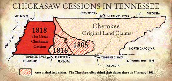
While the Chickasaw Indians lived primarily in northern Mississippi during historic times, their extensive land claims included parts of northern Alabama, West and parts of Middle Tennessee, and western Kentucky. Those Tennessee and Kentucky claims were primarily for hunting grounds.Chickasaw claims overlapped Cherokee claims in Middle Tennessee. Chickasaw land was roughly bounded by the Ohio River in western Kentucky, south with the east side of the Mississippi River through Tennessee into Mississippi to approximately the 34th or 33rd parallel, south-eastward with the northern boundary of their often-unfriendly Choctaw neighbors and into Alabama and to Creek Country, then northward to the Tennessee River. The easternmost border of their land claim ran to the Chickasaw Old Fields, near Chickasaw Island on the Tennessee River east of Muscle Shoals, almost directly south of today's Huntsville, Alabama. Here the Chickasaw lands met and overlapped the Cherokee lands. Their claim meandered north and west -- including some parts of the Elk River and Duck River -- through western Middle Tennessee -- where much of this land was also claimed by the Cherokee -- and finally running to the Ohio River.
The main purpose here is to consider the Chickasaw's loss of their Tennessee land. Yet, because the Chickasaw and their Cessions did not occur in a vacuum, it is reasonable to also consider here some Cherokee Cessions, Tennessee laws, Federal laws, and Chickasaw history.
Sections of this Paper
- A Walk Through Time
- Treaties, Cessions, and the Chickasaw Nation
- The State of Tennessee and the Federal Government
- Chickasaw Treaties -- 1816 and 1818
- The Chickasaw in Mississippi and Oklahoma
- Endnotes


 Go to Tennessee
Counties Selection Page
 Go to Tennessee Genealogy Page
