
Treaty with the Chickasaw or
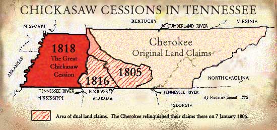
The 1816 Chickasaw Cession
20 September 1816 (21). . . The Chickasaw Nation cede to the United States . . . all right or title to lands on the north side of the Tennessee River. . ."
Tennessee and Alabama both received land from this cession. All Chickasaw land in Middle Tennessee had now been ceded. Note that the date matches the date given by James McCallum in his History of Giles County. Not only did this cession affect south-west Middle Tennessee, it also affected that area of the Buffalo River that fell into the 1st Surveyor's District, formerly the old North Carolina Military Reservation. Additional land was ceded south of the Tennessee River, in Alabama.
County Formations Resulting from
the 1816 Chickasaw CessionLawrence County was established 21 October 1817. Wayne County was established 24 November 1817, but the establishing Act did not become law. It finally passed 8 October 1819. Also, all of Giles County finally opened for settlement.
Lawrence and Wayne Counties were created from western Giles and southern Hickman and Humphreys Counties."
Southern Hickman and Humphreys and southwestern Giles lay in the 1816 Chickasaw cession, an area previously ceded by treaties of 1805-1807."(22)
Additionally, some Alabama Counties were created or enlarged by this 1816 Cession. Pre-1816 maps of Madison County, Alabama, show the southwestern boundary of that county as it conformed to the 1805 Chickasaw Cession line.
Fifteenth Congress
Sess. I. Ch. 35 1818
An Act of Congress, 4 April 1818. (23)
This Act amends the 28 July 1806 act that established the Congressional Line, etc.:
... in Congress assembled. . .it shall be lawful for. . .Tennessee to issue grants and perfect titles on all special entries and locations of land. . .which lie west and south of the line described in the act to which this supplementary...
The Act included the area that, in 1819, became the 7th and 8th Surveyor's Districts.
In Land Laws of Tennessee, H. D. Whitney states:
In 1818, the Federal Government ascertained that there was a large balance of Military land warrants issued by Carolina, still unsatisfied, and that there were no lands fit for cultivation, north and east of said line, upon which to locate them, consequently in that year, in order to redeem their pledge, contained in the act of 1806, and to do justice to the claimants, they directed that all claims, unprovided for, should be satisfied in the lands south and west of said Reservation Line, and authorized the State to issue grants, and perfect titles, as she has done under the act of 1806, north and east of said line. (24)
The important fact here is that this Act passed prior to the 1818 Great Chickasaw Cession and, undoubtedly, was enacted in response to the 1816 Chickasaw Cession.
Treaty with the Chickasaw or
The Great Chickasaw Cession
19 October 1818 (25)In this treaty, the Chickasaw ceded what was to become known as West Tennessee or, in other words, all of their land west of the western waters of the Tennessee River. Only a few small Chickasaw tracts or reservations avoided cession at that time.
...the Chickasaw Nation of Indians cede . . . the land lying north of the south boundary of the State of Tennessee. . . Beginning on the Tennessee River, about thirty-five miles by water below Colonel George Colbert's ferry, where the thirty-fifth degree of north latitude strikes the same; thence west, with the said degree of north latitude, to where it cuts the Mississippi River at or near Chickasaw bluffs; thence up the said Mississippi River, to the mouth of the Tennessee River; thence up the Tennessee River to the beginning.
All West Tennessee Counties were formed from land ceded in this Great Chickasaw Cession.
The Surveyors' Districts (26) In 1819, Tennessee legislated ". . . that part of the State usually denominated the Congressional Reservation, shall be divided into seven districts" [district numbers 7 through 13]. The white settlers poured into West Tennessee. Soon to follow, the last major holdings of the Chickasaw's Tennessee land were surveyed, and distribution began.

A Popular, but Erroneous, Tennessee Map
of the Indian TreatiesThe History of Tennessee, (27) by William R. Garrett and Albert V. Goodpasture, shows a map of the various major Indian Treaty boundary lines. This map has also been reprinted in Messages of the Governors of Tennessee, Volume One (28) and has been the basis for other reconstructed maps. It is considered by many to be the "Bible of Tennessee Treaty Maps."
Unfortunately, this map contains two serious anomalies involving the Chickasaw Cessions. One anomaly is the inaccurate bounds of the area ceded by the Chicaksaw Indians, 23 July 1805. The second anomaly is the omission of the area ceded by the Chickasaw Cession of 20 September 1816.
