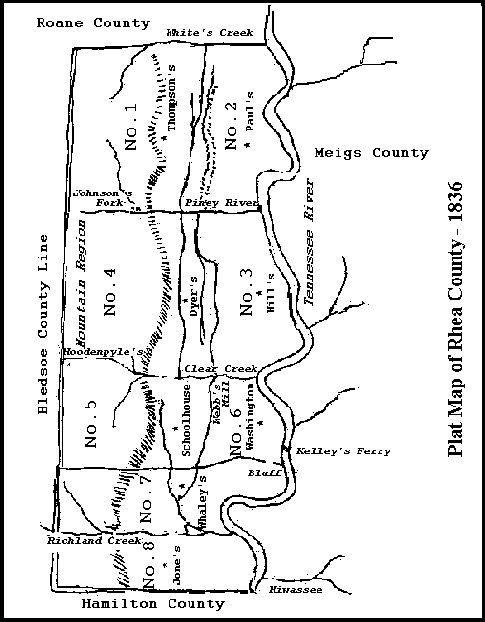
The map below is a re-creation of a Plat Map drawn at the time the 8 original districts were created.

District One
Beginning at the north corner of Rhea County running from thence with the Roane County line to Whites Creek and down Whites Creek to the upper corner of Thomas McKiddy’s land. Thence with his line to the corner. Thence a direct line to the head of Charles Mitchell’s Spring. Thence down his Spring branch to Muddy Creek and down Muddy Creek to Piney River. Thence up Piney River to Johnson’s fork of the same and up said Johnson’s fork to the Bledsoe County line. Thence with said County line to the Beginning. We appoint the place of holding elections in the first district at Jesse Thompson’s.
District Two
Beginning at Thomas McKiddy’s upper corner on Whites Creek. Thence down said Creek to Tennessee River, thence down said River to the mouth of Piney River, thence up Piney River to the mouth of Muddy Creek. Thence up Muddy Creek to the mouth of Charles Mitchell’s Spring Branch. Thence to the head thereof. Thence a direct line to the Beginning. We appoint the place of holding elections in the second district at Archibald D. Paul’s.
District Three
Beginning at the mouth of Piney River, thence up Piney River to the bridge on the middle road. Thence with the Middle road to where Horsby’s ferry road crosses it. Thence a direct line to the nearest summit of the main leading Wolf Creek ridge. Thence with the extreme Height of said ridge to the nearest summit to Clar Creek. Thence a direct line to the mouth of the Cave Spring branch in West’s mill pond on Clear Creek. Thence down Clear Creek with the various meanders thereof to its mouth. Thence up Tennessee River to the Beginning. We appoint the place of holding elections in the third District at John Hill’s.
District Four
Beginning at Piney Piney bridge on the Middle road. Thence with the Middle road to where Hornsby’s ferry road crosses it. Thence a direct line to the nearest summit of the main leading Wolf Creek ridge. Thence with the extreme height of said ridge to its neares Summit to Clear Creek. Thence a direct line to strike Clear Creek at the mouth of the Cave Spring branch in West’s mill pond. Thence up Clear Creek to the head. Thence a direct line to the bridge on Piney River at Beaty’s Turnpike road. Thence with said road to David Hoodenplye’s on the Bledsoe County line. Thence with said County line to Johnson’s fork of Piney and down Johnson’s fork to main Piney River and down Piney River to the Beginning. We appoint the place of holding elections in the fourth district at Spils Be Dyer’s.
District Five
Beginning at David Hoodenpyle’s on the Bledsoe County line, thence with Beaty’s Turnpike road to Piney bridge. Thence a direct line to the head of Clear Creek and down Clear Creek to West’s mill. Thence a direct line to the nearest summit of the main Valley ridge. Thence with the extrreme height of said ridge to a point bearing S 60 degrees E from Samuel Garwood’s, thence a direct line North 60 degrees West intersecting said Garwood’s dwelling house, continuing that course to the Bledsoe County line. Thence with said County line to the Beginning. We appoint the place of holding elections in the fifth district at the School house near Jackson Howerton’s.
District Six
Beginning at the mouth of Clear Creek and running down Tennessee River to the first large bluff above V. A. Gile’s, thence a direct line over the summit of said bluff to Noland’s pond near the Washington road. Thence a direct line to the south corner of district No. 5 on the main valley ridge at a point bearing directly S 60 degrees E from Samuel Garwood’s dwelling house. Thence with the extreme height of said ridge to the nearest Summit to Clear Creek. Thence directly to West’s mill, thence down Clear Creek to the Beginning. We appoint the place of holding elections in the sixth district at the Court House in Washington.
District Seven
Beginning on Tennessee River at the first large bluff above V.A. Gile’s, thence a direct line over the summit of said bluff to Noland’s pond near the Washington road. Thence a direct line to the corner of districts Nos 4 and 6, thence a direct line N 60 degrees W intersecting Samuel Garwoods’s house continuing that course to the Bledsoe County line. Thence with the Bledsoe County line to main Richland Creek. Thence down said Creek to Tennessee River. We appoint the place of holding elections in the seventh district at John Whaley’s.
District Eight
Beginning on Tennessee River at the mouth of Richland Creek. Thence up main or Big Richland creek to the Bledsoe County line. Thence with said line to the North corner of Hamilton County. Thence with the Hamilton County line to Tennessee River. Thence up Tennessee River to the Beginning. We appoint the place of holding elections in the eighth district at the house of B. F. Jones.


The 1836 plat does not display on this page.
Thanks Paul – the map image is fixed now!