Rogersville Town Plat, 1792
Plat of the Town as Laid Out in 1792, redrawn by Warren Amyx
A copy of this map was found at the Stamps Library in 1996 by Billie McNamara. No copyright infringement is intended by posting it here.
This map is from the town as it was laid out in 1792 by Joseph Rogers. Early deeds show that there was a courthouse on Lot 3 before 1792; this courthouse is not mentioned on Rogers‘ map.
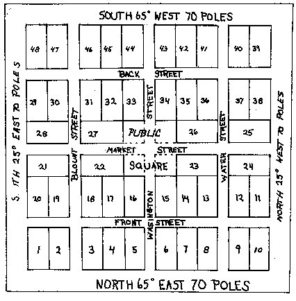
Drawn by Warren Amyx
Modern name equivalents:
- Back Street = Kyle
- Market = Main
- Front = Washington
- Blount = Hasson
- Washington = Depot
- Water = Church