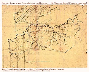
The map* presented here may be the only extant early map of District South of the French Broad & Holston Surveyor’s District. It was found in the papers of Matthew Rhea, and is one of a number of small hand drawn maps that were the basis of Rhea's Map of the State of Tennessee, Taken From Survey By Matthew Rhea, 1832. We date the small District map to be circa 1830. It appears that Matthew Rhea had some independent surveyors create maps of some East Tennessee counties (at least) for inclusion in his 1832 map.
Because of the probable 1830 date, this small map postdates the 1806 establishment of the Surveyors District, District South of the French Broad & Holston, it certainly can not be called contemporary. Still, it is the earliest map of the District that we have found, and it indicates the larger, six by six mile townships within the District. Below is a quote from our paper, “Tennessee’s Early Surveyors’ Districts and District Boundary Documentation, 1806 - 1836.” Located in East Tennessee. This district was formed on the bounds of the tract mentioned in the 1796 Tennessee State Constitution, Declaration of Rights, Section 31: “That the people residing south of the French Broad and Holston, between the rivers Tennessee and the Big Pigeon, are entitled to the right of pre-emption and occupancy in that tract.” Even mentioned in the U. S. Congressional Act of 1806: “. . . the people residing in said State, south of French Broad and Holston, and west of the Big Pigeon Rivers provided for by the Constitution of the State of Tennessee, shall be secured in their respective rights of occupancy and pre-emption. . .” Most of the boundary rivers, above, have gone through name changes since 1790's. The river above Kingston but before Knoxville that was originally called the Holston, later became the Tennessee. The Big Pigeon became the Pigeon, and the then Tennessee is now the Little Tennessee. The southern line of this tract would cross over and into Cherokee lands. The dividing boundary was established in the 2 July 1791, Blount’s Treaty, also called the Treaty of Holston. The southern area of Blount County reached past the treaty line. It was not unusual for the county lines or even the later Surveyors’ District lines to cross treaty lines, only later to be open to legal settlement. In 1797, the Hawkins’ Line was surveyed. That line ran east-southeast from Kingston to Blanket Mountain, later being extended to “Megis’ Post” near Clingman Dome on Iron Mountain. 47 In the Treaty of Tellico, 2 Oct 1798, the Cherokees ceded more land in the southwest of Blount County, south of the original Hawkin0146s Line. Here the boundaries were extended southerly and also eastward to the Chilhowie Mountain area. At the conclusion of the treaty of Tellico a tract of land in southeast Blount County still remained in Cherokee hands. When it was formed in 1806, the boundary description of the French Broad and Holston District was unspecific, according to Whitney. Here we need to return to the Section 31 of the State Declaration of Rights. The district’s southern boundary would simply be “Tennessee” or Little Tennessee. However, it seems that the District did not completely adhere to the Little Tennessee as its southern boundary. Off limits to white settlement was a tract of Cherokee land in southeast Blount County. This tract actually was to fall into the 1819 Hiwassee District. Calhoun’s Treaty of 1819 extinguished all Cherokee claims north of the Hiwassee River which, of course, included any Indian lands that remained north of the Little Tennessee, in Blount County. With the use of the 1851 Hiwassee District map, TSLA #408, we can determine the boundary between this District south of the French Broad and Holston and the Hiwassee the District. There remains little of the District’s records to help us sort out boundary line or land location. Some land grant and county records remain. One can also find an occasional article that might prove helpful.
The District Office was located at Sevierville. There is no extant original map of the District south of the French Broad and Holston. *The original Rhea French Broad map can be found in the Tennessee State Library & Archives in Nashville Tennessee. It is in a small collection of personal papers of Rhea Family Papers, Box 2, (#14). Dr. Wayne Moore (TSLA) provided a copy of the map to us.