Tennesse’s complex history of its public lands dates from the early 1780s, when North Carolina passed several acts concerning the disbursement of its western reserve (now Tennessee). This paper is an overview of those laws and the effects they had on the records and the record-keeping system. It is not a comprehensive study, but treats only this one aspect of a complicated subject -- the relationship between North Carolina and Tennessee up to about 1806. Along with the historical setting and the explanations of the various ensuing laws, examples are given of various types of grants and their supporting papers (warrants, entries, surveys), as well as details on the procedures involved in the maturing, or perfecting, of grants.
In 1777 North Carolina created the first county in its western reserve, Washington County,1 and set up an office there for the sale of public land, with John Carter serving as the entry taker.2 Concurrently, North Carolina opened offices in each of its other counties.3 Land was available for purchase at the price of 50 shillings for every 100 acres.4Washington County’s boundaries at its creation encompassed the entire present-day Tennessee,5 and that entire area was open to entry.6 Speculators soon rushed in, claiming over a million acres. In the next year, however, North Carolina invalidated entries on lands that had not been ceded by the Cherokee. (In 1775, at the Treaty of Sycamore Shoals, the Cherokee had relinquished lands in the extreme northeastern corner of present-day Tennessee.)7
The process of obtaining a purchase grant involved four steps:
1. The interested persons went onto the lands being offered and selected his desired acreage. This physical locating was necessary because North Carolina used the metes and bounds system of survey; thus particular sites could not be pinpointed by consulting maps.As an example, let’s follow one Peter McNemee through this process:2. The person entered on his chosen parcel by describing to the entry taker its location and boundaries. Then entry taker wrote the description in his entry book, assigned it an entry number, and after a waiting period of at least three months, made out a warrant to the county surveyor, ordering him to go onto the chosen acreage, make careful measurements, and draw a plat showing the boundaries. This three months allowed time for anyone with a prior claim to caveat the entry and stop the process.8
3. The surveyor made his survey, drew the accompanying plat, and returned two copies to North Carolina’s Secretary of State.
4. The Secretary of State issued the grant, which bore his signature as well as that of the Governor.
STEP 1: LOCATING THE LAND. Presumably Peter McNemee visited the site where he wished to locate his entry, noting landmarks and probably placing stakes to mark the boundaries. Judging from the wording of the warrant issued by the entry taker, Peter had already been living on the land for some time. (See example below.)
STEP 2: ENTERING THE LAND. Two records -- the entry book and the warrant -- can document this step for today’s genealogists. In 1778 Peter McNemee entered on acreage in Washington County. A copy of his entry does not survive, but the warrant based on his entry does and is transcribed below. In the upper left-hand corner is the entry number, and at the bottom is the entry-taker’s signature. With this warrant, Carter was instructing the county surveyor to go to a particular place on Big Limestone Creek and measure off 640 acres for Peter McNemee.
“State of North Carolina Washington County Decr 31st 1778
#876
To the surveyor of the said county you are hereby required to measure and lay off according to law for Peter McNeme his heirs and etc. six hundred forty acres of land on the waters of Big Limestone at a big spring including his plantation beginning above the head of the said spring running down for complement the 3rd May 1779 given under my hand John Carter, E. T. [Entry Taker]”9STEP 3: SURVEYING THE LAND. When the county surveyor, James Stuart, made his survey, it measured out to 570 acres instead of the expected 640. The survey is included with the plat, although that is not shown here.
“#876
This plat is the form of a tract of land surveyed for Peter McNimee July the 14th 1779 situate lying and being in North Carolina Washington County on Shipman’s fork a branch of Big Limestone Creek, bounded as follows to wit, beginning at two white oaks and a red oak a corner in Hunter’s line thence north 23 degrees west 242 poles to a red oak and white oak, a corner of Wm. Richey’s line... Crossing said creek... Robertson’s line... to the beginning [signed] James Stuart”10STEP 4: GRANTING THE LAND. Then grant bears a number different from the entry number, details the fee paid, contains the surveyor’s description of the boundaries, and identifies Peter McNemee as the grantee.
“State of North Carolina #108
To all to whom these presents shall come greeting know ye that we for and in consideration of the sum of 50 shillings for every one hundred acres hereby granted paid into our treasury by Peter McNemee have given and granted and by these presents do give and grant unto the said Peter McNemee a tract of land containing 570 acres in Washington on Shipman’s Fork of Big Limestone Creek, beginning at two white oaks and a red oak corner in Hunter’s line... [signed] 25 October 1782 Glasgow Sec. by his excellency’s command Alexr. Martain.”11
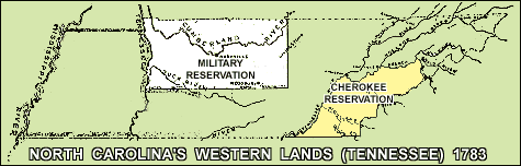
In 1781 North Carolina closed its land offices, primarily because of difficulties relating to the Revolutionary War and the resulting depreciation of paper currency. And, as to the closing of the land office in Washington County, there was an additional reason: in the preceding year North Carolina has passed an act12 to set aside lands in its western reserve to pay the soldiers who had served in its Continental Line by giving them bounty-land warrants redeemable in that area.13In 1782 an area in the Cumberland River Valley of present-day upper Middle Tennessee was officially declared the place for the reservation.14 This land had originally been purchased from the Cherokee in 1775 by Richard Henderson of the Transylvania Land Company.15 North Carolina (and Virginia) disallowed Henderson’s original purchase and then compensated him by giving him 200,000 acres in the Powell River Valley in what is today upper East Tennessee.16 But emigrants had already begun settling on Henderson's original claim.
Surveyors for the North Carolina government went to this Cumberland River Valley and surveyed the military reservation, marking a rectangle that began on the Tennessee River at the 36o 30' meridian line--the line dividing North Carolina from Virginia (now Kentucky) --and running 55 miles to the south, then 130 miles east, then 55 miles north to the 36o 30'.17
The settlers already living on this newly created military reservation were concerned about their property. They petitioned the North Carolina General Assembly, asking for preemption rights to the lands they were living on. Specifically, they were requesting the privilege to purchase those, to the exclusion of other applicants. They wanted to be certain a soldier couldn’t come in with a military warrant and nullify their claims.19 North Carolina agreed to their petition and in late 1782 sent commissioners to the area to negotiate with them. To qualify for preemption rights, a settler had to have been on the land since before 1 June 1780. Preemption rights were limited to 640 acres for each head of household.20 Entries such as the one below were recorded by the commissioners.
“John Rains obtained a preempt of 640 acres of land on Brown’s Creek a branch of Cumberland River about three miles South from Nashboro Beginning at a Conditional line between Roger Topp and said Rains, and running down the Creek for Complt. to include his improvement.”21
A preemption right should not mistakenly be interpreted as a grant. It was simply the right of the settler, in certain conditions, to go through the process of obtaining a grant for the land he was living on. In addition to the Preemptors and the North Carolina soldiers and officers, only a few other people were eligible to receive grants in this reservation:
the surveyors who laid off the reservation boundaries,
the men who served as chain carriers for the surveyors,
the soldiers who guarded the surveyors against Indian attack,
the hunters (not to exceed six) who provided food for all these men,
and the commissioners who dealt with the Preemptors.
Col. Martin Armstrong was appointed entry taker and chief surveyor for the military reservation. His office was to be in Nashville.22 The process of obtaining a military grant differed in a significant way from that for a purchase grant. In a purchase grant, the entry was the first step, citing a specific location and receiving an entry number. In a military grant the military warrant was the first step. It was not specific as to location, other than to say the land must be within the limits of the lands set aside for the officers and soldiers of North Carolina's Continental Line.North Carolina’s Secretary of State made out the military warrants, assigning to each a warrant number.23 When the person holding the warrant (sometimes this was the soldier, but more often it was his assignee) decided upon a particular location, he made entry in Col. Martin Armstrong’s office. His entry cited the specifics of his chosen tract. Armstrong would write the military warrant number in his entry book and, at the same time, assign an entry number. He would issue an order to the surveyor to make a survey.24 When the military grant was issued, it bore a grant number as well as the warrant number, but usually not the entry number.
The three definitions given to the term “warrant” can be confusing to researchers.
As an example, John Yates was a soldier in North Carolina’s Continental Line. The military warrant he received was dated 17 Oct 1783, bore warrant number 22, was written by North Carolina’s Secretary of State, and did not cite a specific location.In one document, it could refer to a warrant issued to the surveyor as one of the steps in a purchase grant.
In another, the term could refer to a military warrant, in which case it would not cite a specific location.
Or, in the third, it could refer to the warrant issued to the surveyor after the military warrant had been entered in Armstrong’s entry book, which like the first mentioned here, would be specific as to location.
“State of North Carolina No. 22. The Honorable James Glasgow, Esq. Secretary of this state to Col. Martin Armstrong. Greeting. You are hereby required to lay off and survey for John Yates a soldier in the line of this state six hundred and forty acres of land within the limits of the land reserved by law to the officers and soldiers. Observing the directions of the Act of Assembly in such case made and provided for running out lands, two just and fair plans thereof with a certificate to each annexed you are to transmit to my office within the time limited by law.John Yates relinquished his warrant by assigning it (probably selling it) to Thomas Kilgore. Kilgore held the warrant for some eight years and then assigned to John McCoy Alston. These assignments appear on the reverse side:
Given under my hand at Hillsboro this 17 October 1783.
[signed] James Glasgow.”25
“Sir, please to survey this warrant for Mr. Thomas Kilgore and make return in his name as he may obtain deed for the same as I have received full satisfaction for the same warrant.The last assignee, John Mc Coy Alston, selected a tract of 640 acres on Red River, with Thomas Johnson, deputy surveyor, surveyed for him, with James Conyers serving as chain-carrier. Martin Armstrong’s signature appears on the document because he was the chief surveyor of the military reservation, not because he was present at the time of the survey.
[signed] John Yates
Mr. Martin Armstrong Surveyor
Test this ___ [blank] day of ___ [blank] 1783.
Witnesses: Thomas Killgore, Junr., Thomas Yeats, William Yeats.”“I do hereby assign over all my right and title to a warrant of six hundred and forty acres of land warrant now lodged in the land office at Nashville No. 22 to John McCoy Alston for value recd. as witness my hand this 29th day of August 1791.
[signed] Thomas Killgore
Test: James Drumgoole, William Harrison”26
“Tennessee County, August 16th 1791In the resulting grant, note the following:
By virtue of a military warrant No. 22 Located 13th September 1784 I have surveyed for John McCoy Alston assignee of Thomas Kilgore assignee originally of John Yates six hundred and forty acres of land lying on Red River, beginning at a red oak on the bank of said river where the colony line crosses the same. . . crossing Spring Creek. . . to the beginning.
[signed] Thos Johnson D. Sur.y
[signed] Mart. Armstrong Sur.y
[signed] Jams Conyers”27
It was normal procedure for warrants and entries to be assigned numerous times, and for the various assignees not to be listed on the actual grant. The above grant indicates Yates had been a private in the North Carolina Line and serves as the necessary proof that this is a military grant. A grant within the military reservation that was for service performed by a guardsman, commissioner, surveyor, chain-carrier, or hunter will name the person and describe the service rendered. 30The grant number, #2150, is not the same number as the warrant number, #222
John McCoy Alston is listed as the assignee of John Yates, the soldier.
Thomas Kilgore is not mentioned. “State of North Carolina No. 2150
Know ye that we have granted unto John McCoy Alston assignee of John Yates a private in the Continental Line of said state six hundred and forty acres of land in our County of Tennessee28 on Red River beginning on the bend of said river where the county line crosses the same, runs east with the Virginia line 112 chains and 80 links to a stake on the barrons, thence south crossing Spring Creek... to the beginning. Date May 20th 1793.
[signed] J. Glasgow Secretary Richd. Dobbs Spaight Warrant No 22. Thos. Johnson D.S. James Conyers, _______ [blank] Hinds C.C.” 29Few North Carolina Revolutionary War soldiers went to the western reserve to exchange their warrants for lands. Instead, they sold their warrants, usually for small sums, and, more often that not, to speculators. In the overwhelming majority of cases, it was the speculators who held the warrants and entries in the military reservation, not the soldiers. 31
In late 1783, North Carolina passed another act relating to its western reserve; and, once again, the speculators were quick to respond, entering on nearly four million acres. This law, soon known as the Land-Grab Act, was in effect for only seven months-- from 20 October 1783 until 25 May 1784. During that limited time, North Carolina opened up its entire western reserve to purchase by anyone who could pay the entry fee of 10 pounds per 100 acres. The only areas not open to entry were the military reservation and the Cherokee reservation.32North Carolina had incurred tremendous debts during the war by issuing IOUs for goods and services. It planned to recover those by exchanging them for lands in the western country. Paper currency or IOUs, called specie certificates, could be exchanged at the rate of 10 pounds per 100 acres.33 An office was opened in Hillsboro, North Carolina, for the purpose of handling the IOUs and the entries. John Armstrong was the entry taker.34 In this family affair, his brother Col. Martin Armstrong operated the only other office for the western reserve, serving, as has been noted, as the military entry taker and chief surveyor.
With John Armstrong’s office 200 miles from the lands offered, the speculators were in an advantageous position. They had the money and the know how to secure ownership of the best parcels (by hiring people already living in the western country to locate choice pieces for the speculators to enter on). The limit per entry was 5,000 acres, but speculators sidestepped that restriction by joining entries together into a larger survey. In this manner, they were able to lay claim to vast, contiguous holdings.35
When the Land-Grab Act was repealed in May of 1784, the entry- taker's office in Hillsboro was closed. No more entries could be made, but those that had already been made could continue through the process of becoming grants. In many cases, it was 20 to 30 years before those entries matured into grants, often because they were in areas still under Indian title (many in West Tennessee).36
In May of 1784 North Carolina passed another act relating to its western reserve. This one stated that if an entry had been made in John Armstrong’s office and the enterer afterwards discovered someone else had already entered on that same piece of property, it would be permissible for that second person to take his original entry number and apply it to an entirely different piece of land.37As an example, an entry was made out to Andrew Kerr in May of 1784 and assigned entry number 2222. Kerr entered on 5,000 on the east side of the Mississippi River.38 (This is in what is today extreme West Tennessee.) When the grant was issued, it was based on an entirely different parcel. It was for 5,000 acres, just as in the first entry number 2222, and it even mentioned number 2222. But, this time the property was in Greene County on the north side of the Tennessee River on Swift Creek, in what is today EAST Tennessee.
ENTRY:
“#2222 Andw. Kerr, May 21st 1784 5000 acres lying on east side of Mississippi joining James Stewart's entry on the third little Chickasaw bluff said bluff... running out from the river for complement. Warrant issued 12 January 1785.”39GRANT:
“State of North Carolina No. 108 Know ye that we have granted unto Andrew Kerr 5,000 acres of land in the County of Greene upon the north side of Tennessee River on Swift Creek beginning at a dogwood and white oak dated November 1st 1786.[Signed] J. Glasgow, Sec. Rd. Caswell.In other words, with this law speculators who had overlapped their entries in their rush for the land got a second chance to locate somewhere else, even though the Hillsboro office had been closed.
Warrant No. 2222, surveyed by J. Taylor, John Ray, Wm. Moore, Quinton Moore, and Willm. Buckingham chain carriers.”40
In 1784 North Carolina, reacting to the possibility it had set aside insufficient acreage for its officers and soldiers, passed an act permitting a soldier to obtain a military grant outside the military reservation if he could not find enough cultivatable land within the reservation. 41 The only area exempted from this was the Cherokee Reservation. 42 This reservation had been set aside in early 1783 as the Cherokee’s eternal hunting grounds. But, in the remainder of the western reserve, military warrants were permissible, even though at that time very little land had been ceded by the Indians. (The only ceded portions were in the extreme northeastern corner and in the area where the military reservation had been laid out.43 ) North Carolina considered it had the right to award the soldiers the unceded lands since the Indians had sided with the British during the Revolutionary War, thus forfeiting their claims.44Eventually, military grants outside the military reservation totaled some eight million acres. 45 With only about 29 million acres in the state 46 -- and a good portion of that being poor, hilly, and mountainous -- North Carolina was giving away the best lands of its western reserve to the speculators, not the soldiers.
It is important to understand how long the above mentioned laws remained on the books. In 1784 North Carolina made an offer to cede its western reserve to the United States, but before any action was taken, it rescinded that offer. 47 When it offered the lands to Congress a second time, in 1789, among the terms and conditions were:that the claims of its Revolutionary soldiers should be made good, even if there was not enough cultivatable land within the reservation;
that entries and warrants made before the cession would have the same force and effect as if such cession had not been made;
that if any person had made his entry in John Armstrong’s office and located on the same land already entered by someone else, he would be permitted to locate such entry for lands on which no entry had been located;
that such claims should be perfected by 1792. 48
For a period of six years (from 1790 to 1796), the area was known as the Territory of the United States South of the River Ohio, 49 usually referred to as the Southwest Territory. During those six years, the United States government honored the North Carolina warrants and entries that had been made under those laws -- but only for entries issued on ceded lands. 50 It did not permit entries and surveys to be matured into grants if they were in areas that Indians had not yet ceded. The United States felt the Indians had legitimate claims, and only if and when they gave up their claims could North Carolina issue grants on the entries and warrants in those areas. 51During the six years that Tennessee was a United States territory, there were no federal grants issued in the area. Thomas Jefferson's report to Congress dated 1791 summarizes the outstanding entries and warrants and highlights the confused situation that existed:
“On a review... of all the [claims by United States citizens], it appears probable they cover all the ceded lands susceptible of culture, and cleared of the Indian title . . .” 52North Carolina issued grants during Tennessee's territorial years, both in the areas ceded by the Indians and in areas not ceded -- even though the United States had said no grants were to be issued for lands still claimed by the Indians. For the most part, however, the speculators just held on to their entries and warrants, anticipating further cessions and waiting for the price of western lands to rise -- a condition that wouldn't occur until substantial numbers of settlers went into the area. 53Let's look at two grants made by North Carolina during the years Tennessee was a United States territory. Then first grant is within the legal area and is for 60,000 acres. It is dated 4 January 1795, is for acreage lying on the bank of the Clinch River, and is priced at 10 pounds for every hundred acres. In this instance, the grantees, Stokley Donelson and James W. Lackley, had combined several adjoining 5,000 acre entries into one survey and grant.
“The State of North Carolina. No. 209The second example is a grant North Carolina issued during territorial years that was NOT within the ceded areas. It is dated 1791 and is for 5,000 acres on Reelfoot River, the waters of the Mississippi. (In 1791 the Chickasaw claimed what is now West Tennessee, but regardless of that, North Carolina was issuing a grant there. In fact North Carolina surveyors had laid off hundreds of thousands of acres in claims as early as 1785, despite this territory's being nominally off-limits to North Carolina claims.)
To all whom these presents shall come. -- Greeting: Know ye, that we, for and in consideration of the sum of ten pounds for every hundred acres hereby granted, paid into our Treasury, by Stokley Donelson and Jas. W. Lackley have given and granted and by these presents do give and grant unto the said S. Donelson and J.W. Lackley a tract of land containing 60,000 acres, lying and being in our Eastern District beginning at two elms and a sycamore standing on the bank of Clinch River corner to Col. Jas. Glasgow's 6,000 survey...
[signed] Richard Dobbs, Spaight, Esquire, our Governor...
[signed] J. Glasgow, Secretary.” 54
“State of North Carolina No. 344
To all whom these presents shall come. -- Greeting: Know ye, that we, for and in consideration of the sum of ten pounds for every hundred acres hereby granted, paid into our Treasury, by Henry Boyars have given and granted and by these presents do give and grant unto the said Henry Boyars, a tract of land containing 5,000 acres... on Reelfoot River the waters of the Mississippi... this December 26th 1791.
[signed] Alexr. Martin
[signed] J. Glasgow, Secretary.
Warrant No. 1680.”55
The Problems Caused by These Acts
Statehood for Tennessee came in 1796, and additional Indian treaties opened up more lands for settlement. Again, it was the speculators who benefited first. Those who had been holding onto their North Carolina entries and warrants now brought them forth, laying claim to the best parcels in those newly ceded areas. They were allowed by the Tennessee government to do this, because of a provision to that extent in the United States Congressional Act creating the state. Additionally, soldiers in North Carolina were still coming forward well into the 1790s to claim their military warrants; and those had to be satisfied out of Tennessee lands as well.56The Tennessee government was caught between a rock and a hard place. It couldn't open offices for the sale of its public lands as long as those North Carolina entries and warrants were still outstanding. Those unmatured grants were like dark, menacing clouds hovering over the state. Tennessee argued with North Carolina and even threatened. North Carolina would make a tentative agreement to stop issuing grants on the outstanding warrants and entries; then it would postpone going through with the agreement. In 1799, in exasperation, Tennessee offered a reward of $5,000.00 to anyone apprehending North Carolina surveyors making surveys on Tennessee lands.
Until 1806 there continued to be conflict with North Carolina regarding the lands. Tennessee issued no grants during those 10 years (1796-1806) because of the warrants and entries that North Carolina had issued and the military warrants it was continuing to issue. Tennessee could not open a land office so long as the confusion existed over who had ownership of its public lands.57
During these same years, settlers were coming into the area by the tens of thousands. They wanted land. But they couldn't buy where the Indians still laid claim; in other areas, speculators held title to much, if not most, of the best parcels. Many of the speculators were nonresident owners; so an incoming settler couldn't be sure when he picked a tract whether a speculator might not already have an entry on it. This resulted in much confusion and uncertainty and many lawsuits.58
Finally, in 1806, the United States government stepped in as arbitrator and brought about a settlement between Tennessee and North Carolina with these terms, among others:
Tennessee could open land offices in the state, but only in the areas that had been ceded by the Indians.
North Carolina could continue to issue grants in Tennessee for military service of its soldiers, as well as grants for entries and warrants based on the Land-Grab Act of 1783-84. (In other words, Tennessee had to continue honoring North Carolina's outstanding entries and warrants. There would be no financial gain for Tennessee, either, since only minimal fees would be involved in surveying the entries and registering the grants. The larger amounts of monies -- the 10 pounds per 100 acres that had been paid for the claims entered during the Land-Grab Act -- had gone into North Carolina's coffers many years earlier.)
North Carolina could continue to issue grants on Tennessee lands, based on those earlier warrants and entries, but Tennessee would do the paperwork. The grants would be “Tennessee” grants.
The United States set aside and withheld settlement from West Tennessee -- an area still claimed by the Chickasaw -- and also a small area in southwest Middle Tennessee claimed by the Cherokee. (See map below) North Carolina warrants or entries could not be satisfied out of this Congressional Reservation and no settlers were to go onto this area as long as the Chickasaw still claimed it. (Surveyors had been in this area some 20 years earlier, marking off parcels to be entered on under the 1783-84 Land-Grab Act; but the United States, under the terms of this Compact, prohibited those from becoming grants because of the Indians' claim to the lands. The federal government planned to profit later from the sale of the remaining lands in this Congressional Reservation if Indian title was extinguished. But Tennessee’s lands and land records were by this time so muddied, the United States eventually gave up hopes of this materializing.)
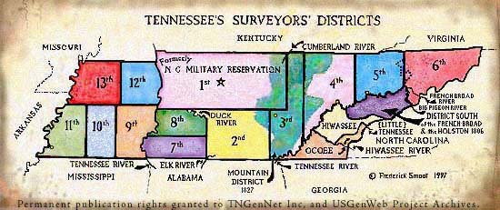
No entries or warrants could be satisfied using lands in the Cherokee Reservation in Southeast Tennessee. 59 A series of land cession treaties with the Cherokee in 1805-6 opened up considerable new territory in which military grants were located; and, as a consequence of the Compact of 1806, Tennessee was finally allowed to open land offices; and it set up six surveyors’ districts. 60
Tennessee Surveyor’s Districts 61
Tennessee, as stated in the terms of the Compact, was required to issue grants based on early North Carolina entries and warrants. The following is State of Tennessee grant no. 431. It is “by virtue of part of a warrant dated 1787” and refers to a warrant out of John Armstrong’s office in the 1783-84 time period. 62 It is for acreage in Warren County in Middle Tennessee. Researchers often misunderstand grants such as this one, assuming when they see a warrant number in a grant that it is indicating a military warrant. One clue to watch for is whether the grant is based on a warrant out of John Armstrong's office, not Martin Armstrong’s. Also, as this example shows, the grant does not say a soldier was involved, which it MUST if it is a North Carolina military grant.Grants like this one can be found in the Tennessee grant books labeled “General Grants,” and relate to State of Tennessee grants based on North Carolina warrants and entries. They purposely include mentions of entries made in John Armstrong’s office so as to provide evidence that Tennessee was abiding by the terms of the Compact.
“The State of Tennessee - No. 431
Know Ye, that by virtue of part of Warrant No. 16789 dated the 19th day of February 1787, issued to David Ross by John Armstrong entry officer of claims for the North Carolina western lands and entered on the fifteenth day of September 1807 by No. 371 there is granted by the said State of Tennessee unto James Winton assignee of the said David Ross a certain tract or parcel of land containing two hundred and sixteen acres lying in Warren County... beginning at two hornbeams in James Hubbard’s line... to the beginning.
Surveyed the ninth day of January 1808...
[signed] John Sevier, Governor
[signed] R. Houston, Secretary” 63Below is an example of a North Carolina military grant issued by the State of Tennessee. This grant, to Joseph Linn the assignee, was given for the military service of Francis Cornwall. It is for acreage in Madison County, in West Tennessee, and the date in 1822, some four years after the Chickasaw relinquished their rights there. After that cession, the United States gave Tennessee the power to perfect titles and issue grants in the Congressional Reservation. 64 Once again, the United States had not issued any federal grants because of the muddied situation caused by outstanding North Carolina entries and warrants. However, under the terms of the United States’s relinquishment, Tennessee was to honor in that area also those warrants and entries that North Carolina issued so many years before. 65
“The State of Tennessee No. 47
Know ye that in consideration of military service performed by Francis Cornwall to the State of North Carolina Warrant No. 4762 dated the 27th day of February 1797 for 274 acres and entered on the 10th day of February 1822 by No. 888, there is granted by the said State of Tennessee unto Joseph Linn, assignee of said Francis Cornwall a certain tract or parcel of land containing two hundred and seventy four acres by survey bearing date the 2nd day of May 1822 lying in... Madison County...
[signed] Wm. Carroll
[signed] Daniel Graham, Secretary” 66The extent of damage these laws caused the Tennessee government is staggering. In the TSLA’s card file of legislative petitions are references to hundreds by persons having difficulty proving the validity of their grants. Uncounted lawsuits in early county court minutes relate to warrants, entries, and grants. In the Tennessee Supreme Court there are scores of cases on the subject. Litigation in Tennessee must have made its lawyers as rich as the North Carolina laws had made its speculators.
Fraudulent Records
The confusion caused by the laws was compounded by extensive fraud. There were fraudulent papers, fraudulent signatures, manipulation of records -- all to a very large degree. A fraud scam was inadvertently discovered by Andrew Jackson, who learned that William Terrell (a prominent speculator) and his nephew, William Terrell Lewis, had gotten some former North Carolina Revolutionary War officers intoxicated and were attempting to get those officers to sign fraudulent papers certifying men as former Continental soldiers.67Upon hearing of this incident, Andrew Jackson reported it to the United States Senator from North Carolina, Senator Alexander Martin. Out of that grew an investigation by the North Carolina government. It was found that other types of record manipulation were taking place as well. Martin Armstrong was issuing military warrants to non-soldiers, both Martin and John were issuing duplicate warrants, and they were forging signatures. Also, they were carelessly letting grants overlap. Even James Glasgow, who was North Carolina's Secretary of State for nearly twenty years, was heavily involved in this scam. The entire incident came to be known as the Glasgow Land Fraud. A more complete detailing can be found in Dr. Albert Bruce Pruitt’s “Glasgow Land Fraud Papers 1783- 1880: North Carolina Revolutionary War Bounty Land in Tennessee.”68
Commissioners were appointed to investigate the fraud. They estimated in 1799 that upwards of 700,000 acres had been accumulated in this scam by some fifty or so persons. The resulting suit was never fully settled. Many who were involved were by this time living in Tennessee and refused to go back to North Carolina to be tried. 69 Tennessee never fully recovered from the mess the fraud had made of its records. In fact, it is quite common today for a researcher to be unable to trace a piece of property from the original grant.
Not all of the men who were big speculators were involved in the fraud, but several were; and it might be helpful to know who some of them were. There was Col. Martin Armstrong, of course. He obtained grants totaling more that 260,000 acres. His brother John also had grants for many thousands of acres. Stokley Donelson was perhaps the largest speculator of all. At one time, while he was in partnership with William Terrell, together they held warrants for over a half-million acres. 70 Stokley Donelson had political connections, but those eventually proved to be his undoing. He was the son-in-law of James Glasgow; but he was also the brother-in-law of Andrew Jackson, the person who exposed the fraud.71 Then there were the Blount brothers: Thomas Blount, John Gray Blount, and William Blount. The latter was the governor of the Southwest Territory during 1790-1796. All three were heavily into speculation, and they were allegedly manipulating the records as well.72
North Carolina attempted to resolve the situation in several ways:
In 1799 and 1800 it created more stringent rules regarding military warrants.
Stronger proof of a soldier’s service was required.
Procedures in the land offices were changed.
It set up a Board of Commissioners to judge the validity of military warrants.73 The fraud had a rippling effect on other Tennessee land records. Many titles that had been perfected earlier were now called into question.74 Tennessee set up a board of Commissioners to pass on the validity of those particular grants.75
The Good, Bad, and Ugly of Land Speculation
All early speculators do not deserve a bad rap. Eventually in Tennessee (as in other states), there were second generation speculators who bought up lands on a smaller scale, usually in only one or two counties. Speculation was a common business enterprise in those days. For the settler it served as a means by which the areas that were ceded could be opened for purchase. The average person could not have gone into the wilds and surveyed large tracts, paid entry fees, and then advertised their availability. For all their avid pursuit of greed and self-interest, the aims of the speculators to promote immigration and sell their lands at a profit did coincide with the desire of westward-bound settlers for new and fresh land.
As to the problem with the outstanding warrants and entries that blanketed Tennessee, eventually the state passed laws that encouraged settlement in spite of the confusion. In 1806 Tennessee passed an act setting up occupant grants, a method whereby settlers who had been in an area for a certain length of time prior to a specific date (and these dates varied according to the various occupant laws) would have the right to apply for grants to the exclusion of anyone else -- for a limited period of time, and for a limited number of acres. In this manner vacant and un-appropriated lands became available to the first settlers in the area, as did any lands that had earlier been clouded by North Carolina warrants and entries, but upon which taxes had not been paid, thus making them liable to occupancy.76 To be eligible for these occupant grants settlers had to meet two conditions: Occupant Grants
When the area of West Tennessee was ceded by the Chickasaw in 1818, it was laid out in five-mile square townships, not the six-mile square townships as the federal public lands in other states.78 Researchers will find grants and deeds in West Tennessee described in sections, townships, and ranges; but they also can find earlier North Carolina grants with metes and bounds descriptions for lands in this same area.They had to have had three years' residency on the land they sought to claim.
They had to have made improvements upon the land. 77
The Surviving Records
To compound the difficulty of understanding all this is the problem that many land records have been lost. The grants do survive. Those issued by North Carolina relating to Tennessee lands can be found in the original (or on microfilm) at the North Carolina State Archives. Copies of the same in TSLA were handwritten in 1804 by John Overton, a Tennessee judge, and his staff, in an effort for Tennessee to determine what lands had already been granted. 79 The grants that Tennessee issued have been microfilmed. A card file at TSLA indexes those, as well as the North Carolina grants for lands in present-day Tennessee.80 It is the supporting papers, such as entries, warrants, and surveys that are not all extant. The extant papers are arranged in the following manner at TSLA, all on microfilm:
Tennessee has handwritten copies of some North Carolina military warrants, with the majority being for those perfected after 1796. Others are in the North Carolina State Archives.
In Record Group 50, Tennessee Early Land Records, are entry books for some of the surveyors' districts. The first six districts were set up in 1806, and more were added as additional areas were ceded by the Indians. Only a portion of these records survive.
Also in RG50 are handwritten copies of John Armstrong’s entry books and what survives of the papers of Martin Armstrong. Here also are the Board of Commissioners’ papers, detailing the commissioners’ attempts to determine which of the questioned grants were valid and which were not.
Microfilm Accession No. 1177, North Carolina... Warrants, Plats, Etc., contains what survives of warrants and plats connected with North Carolina grants for tracts in present-day Tennessee. These are arranged by county and then alphabetically by the name of the person for whom the survey was made. The originals of these are housed in the North Carolina State Archives. 81
Found among Tennesse’'s microfilmed county records are occasional entry books for scattered years, usually beginning in the 1820s,with some being earlier. It was in this time period the surveyors' districts were done away with and the requirement was made that people were to make their entries in the individual counties. According to Dr. Albert Bruce Pruitt, whose two books on this subject have been cited numerous times in this paper, there are additional supporting papers still in North Carolina which have not as yet been filmed. Another of his books, “Petitions for Land Grant Suspensions in North Carolina 1776-1836,” contains some abstracts of petitions regarding Tennessee lands.
Likewise, TSLA has many of the warrants, entries and surveys for Tennessee grants that are as yet unprocessed, although cataloging is currently in progress.
Accessing Tennessee’s Land Records
Through the Family History Library In addition to being available at TSLA, grants by North Carolina and Tennessee for Tennessee lands, as well as the surviving warrants, are available on microfilm at the Family History Library (FHL) in Salt Lake City and through its lending program at family history centers and selected libraries. The records are detailed in the FHL Catalog (on fiche or computer- based) in these categories:
At this writing, films of the supporting papers (the entries, surveys, and plats) are not available at FHL, but are only at TSLA in Record Group 50 and in Mf. Ac. No. 1177, and in the North Carolina State Archives (if relating to North Carolina grants).AUTHOR: North Carolina. Secretary of State.
North Carolina and Tennessee Revolutionary Warrants, 1783-1737.
FHL Film Nos. 1,013,361 through 1,013,375.
AUTHOR: Tennessee. Governor.
Land grants, 1775-1905, 1911. Index.
FHL Film Nos. 1,002,725 through 1,002,747; 1,002,714.
AUTHOR: Tennessee. Governor.
Land Grants, 1775-1905, 1911.
FHL Film Nos. 1,013,360; 1,013,300 through 1,013,322; 1,012,790 through 1,012,825; 1,012,940 through 1,013,054; 1,013,297 through 1,013,299; 1,013,323 through 1,013,359; 0,966,941 Items 1 and 2.These film numbers can also be located by searching the FHL catalog under the following categories:
NORTH CAROLINA. Land and Property.
NORTH CAROLINA. Military Records. Revolution, 1775-1783.
TENNESSEE. Land and Property.
TENNESSEE. Military Records. Revolution, 1775-1783.
In Conclusion
Researchers working with Tennessee’s land records should keep in mind the following:
North Carolina Revolutionary War military grants can be found almost anywhere in Tennessee, with the exception of the Cherokee Reservation. (When the last of the Cherokee lands were ceded, those were laid out in true six-mile square townships.82 )
Speculators became the grantees of much of Tennessee's best lands, because they bought up the soldiers' warrants. They then sold these in smaller tracts to incoming settlers.
Tennessee's grant records are unpredictable. They cannot be expected to be stated in a certain format. Their content depends on what type of grant is involved and the law under which the entries and warrants for a particular grant were issued, as well as the section of the state to which the individual laws applied.83 ENDNOTES
Gale Williams Bamman is a Certified Genealogist, a Certified Genealogical Lecturer, a trustee of BCG, a trustee of APG and review editor of APGQ, and a former vice-president of GSC and former president of BCG. Her articles have been published in several major genealogical journals. In 1995 she received the “NGS Quarterly” Award for Excellence; and for serving as program co-chair for the 1996 NGS/CIS, she received the NGS Award of Merit.Appreciation is given to the staff at the Tennessee State Library and Archives for sharing their knowledge of Tennessee's early history and the North Carolina land laws, and especially to Wayne C. Moore, Ph.D., Archivist. Credit is also given to Albert Bruce Pruitt, Ph.D., of Whitakers, North Carolina, for the valuable assistance his several publications provided.
1. Clark Walker, Ed., The State Records of North Carolina, Laws: 1777-1788 (Goldsboro, NC.: Nash Brothers, 1905) XXXIV:141. (shown hereafter as SRNC)
2. L.D. Smith, “Land Laws of Tennessee”, Tennessee Law Review 1 (November 1922) 30-43.
3. SRNC, Vol. XXIV, pp. 43-48.
4. Ibid.
5. SRNC, Vol XXIV:141.
6. Ibid.
7. A.V. Goodpasture. “Education and the Public Lands in Tennessee”, The American Historical Magazine (January 1899), 4:210-228.
8. SRNC, Vol XXIV:43-48.
9. North Carolina Secretary of State Office. Warrants, Plats, Etc. Tennessee State Library and Archives (shown hereafter TSLA) Mf. Ac. No. 1177. Roll 391. Washington County, Tennessee, Shuck #238.
10. Ibid.
11. TSLA, Land Grants. Watauga Purchase. Roll 24, pp. 343-344. The front pages of this volume contain the “patents” made by Charles Robertson and Jacob Brown, trustees of the lands ceded in the Treaty of Sycamore Shoals. This book was transferred, at the creation of Washington County, to that county's court, where many North Carolina purchase grants were then recorded.
12. SRNC, XVI:337-39.
13. SRNC, XXIV:419-422. Continental soldiers (or their heirs) qualified for acreage as follow: privates 640 acres; noncommissioned officers 1,000 acres; subaltern 2,560 acres; captain 3,840 acres; major 4,800 acres; lieutenant colonel 5,640; lieutenant colonel commandant 7,200 acres; colonel 7,200 acres; brigadier 12,000 acres; chaplain 7,200 acres; surgeon 4,800 acres; and surgeon's mate 2,560 acres. In 1783 an act reduced the amount of land according to length of service and allowed privates 225 acres for two years’ service or 274 acres for three years’ service. Pruitt, A.B. Glasgow Land Fraud Papers 1783-1800: North Carolina Revolutionary War Bounty Land in Tennessee (Albert Bruce Pruitt: n.p., 1988), iii.
14. SRNC, XVI:482-85.
15. SRNC, XXIV:530-31. The purchase by the Transylvania Land Company occurred at the same time and place as the Treaty of Sycamore Shoals.
16. SRNC, XXIV:530-531.
17. SRNC, XXIV:483.
18. William Robertson Garrett, and Albert Virgil Goodpasture. History of Tennessee. 1903. Repr. (Nashville; Brandon Printing Co., 1905), 152. The map has been enhanced by this writer to make the areas under discussion more easily located.
19. SRNC, XXIV:629-30. Some 70 pre-emptioners are named herein, as well as 63 who had been killed in the defense and settlement of Davidson County, and another 19 who had come after 1780 but who were to receive pre-emptions because of their significant bravery. Irene M. Griffey lists pre-emptioners, or their assignees, noted by the commissioners who visited the area in early 1783 in her publication, The Pre-emptors; Middle Tennessee's First Settlers (n.p.: by the author, 1989). Ms. Griffey cites as her source an “original record book kept by David Shelby for the commissioners ...preserved in the North Carolina State Archives.” The 484 peremptions herein are dated 1 January 1783 through 10 March 1783. Other pre-emptioners qualified at later dates and their grants can be found in no particular order among the early North Carolina grants, although some pre-emption rights are detailed in Record Group 50, TSLA, Series 10, Roll 51, Book 15. See also Warrants -- North Carolina Revolutionary War Guard Rights and Pre-emptions 1792- 1803. And, see Roll 53, Book 1, Preemption Book, Davidson County 1790-1791.
20. SRNC, XXIV:421
21. Griffey, The Pre-emptors, p. 1, #5.
22. SRNC, XXIV:483, 567.
23. For a listing of North Carolina’s military warrants, see North Carolina Daughters of the American Revolution, Roster of Soldiers from North Carolina in the American Revolution (Durham, N.C.: The Seeman Press, 1932).
24. Albert Bruce Pruitt. Glasgow Land Fraud Papers, Vol 2: North Carolina Revolutionary War Bounty Land in Tennessee (A.B. Pruitt; n.p., 1993), iii.
25. Revolutionary War Warrants, TSLA, Roll 1, Nos. 22-387, No. 22.
26. Ibid.
27. Ibid.
28. Tennessee County was created in 1788 and was dissolved in 1796. Its records are now included with those of Montgomery County.
29. North Carolina Land Grants, TSLA. Roll 4, Book B-2, p. 29.
30. Grants to these individuals were not recorded in any specific grant volume, but can be found randomly in several of the early North Carolina land grant books. However, many of the warrants issued to the guardsmen can be found in North Carolina Revolutionary War Warrants, TSLA, Roll 10, Guard Rights A-W; and in RG 50, Series 10, TSLA, Roll 51, Book 15, Warrants -- North Carolina Revolutionary War Guard Rights and Pre-emptions 1792-1803.
31. Thomas Perkins Abernethy, From Frontier to Plantation in Tennessee (Chapel Hill: The University of North Carolina Press, 1932), 53-54.
32. SRNC, XXIV:478-482. Also Walter Lowrie and Matthew Sr. Clair Clark, American State Papers. Class VIII. 8 Vols. (Washington: Gales and Seaton, 1832), v:22-25.
33. SRNC, XXIV:479.
34. SRNC, XXIV:478-482. Also Pruitt, Glasgow Land Fraud, iii.
35. Abernethy, From Frontier to Plantation, 53. Also A.B. Pruitt, Tennessee Land Entries: John Armstrong’s Office, Part 1, Land Entries (Albert Bruce Pruitt: n.p., 1995), iii-iv.
36. Harriette Simpson Arnow, Seedtime of the Cumberland. (New York: Macmillan & Co., 1960), 329.
37. SRNC, XXIV:683.
38. Record Group 50, TSLA, Roll 2, Series II, Entry Books, 1:318.
39. Ibid.
40. North Carolina Land Grants. TSLA, Roll 5, Book C, p. 260.
41. SRNC, XXIV:562.
42. SRNC, XXIV:479.
43. Garrett and Goodpasture, History of Tennessee, 130-35.
44. L.D. Smith, Tennessee Law Review, 1:30-43.
45. Robert E. Corlew, Tennessee; A Short History. 1969. 2nd Ed. (Knoxville: University of Tennessee Press, 1981), 157.
46. Encyclopedia of Tennessee (New York: Somerset Publishers, Inc., 1993), 11.
47. SRNC, XXIV:678-679.
48. Thomas B. Jones, “The Public Lands of Tennessee,” Tennessee Historical Quarterly (Spring 1968) XXVII: 19. Abernethy, From Frontier to Plantation in Tennessee, 182-183.
49. John Haywood, The Civil and Political History of the State of Tennessee, 1823, repr. (Knoxville, Tenn.: Tenase Company, 1969), 262-64.
50. Stanley J. Folmsbee, Robert E. Corlew, and Enoch L. Mitchell, History of Tennessee. (New York: Lewis Historical Publishing Co., Inc., 1966), 269.
51. Laurence F. Schmeckbrier, The Office of Indian Affairs: Its History, Activities and Organization, (Baltimore: The Johns Hopkins Press, 1927), 5.
52. Lowrie and Clark, eds., American State Papers, V:22-25.
53. Carl Driver, John Sevier, Pioneer of the Old Southwest. 1932. Repr. (Nashville: Charles and Randy Elder Booksellers, 1973)p. 61.
54. North Carolina Land Grants, TSLA. Roll 20, Book 9, p. 251.
55. North Carolina Land Grants, TSLA. Roll 5, Book C, p. 196.
56. Corlew, Folmsbee, and Mitchell, History of Tennessee, 283-285.
57. Clarence Edwin Carter, ed.. The Territorial Papers of the United States, Vol IV, The Territory South of the River Ohio 1790- 1796(Washington: Government Printing Office, 1936), IV:iv.
58. For an example of situations like this, see Middle Tennessee Supreme Court Transcripts. TSLA. Box 31, 1825. “John McCarver vs William Cassles.”
59. Garrett and Goodpasture, History of Tennessee, 152-3. A further condition, not discussed in this paper, dealt with preemption rights of settlers living south of the French Broad and Holston rivers, in what is today East Tennessee. For overview of this topic, see Abernethy, Thomas, From Frontier to Plantation in Tennessee, 184-186; and Smith, L.D. Tennessee Law Review, 2:188-189.
60. Henry D. Whitney, ed., The Land Laws of Tennessee (Cincinnati: W.H. Anderson & Co., 1893), Part 1:119-124.
61. This map was hand-drawn by Fred Smoot based on his research. There is no extant original map of the combined Surveyor’s Districts. For the purpose of this article, only districts one through six and the District South of the French Broad and Holston should be noted..
62. Tennessee General Grants, TSLA, Roll 26. Book B, p. 150.
63. Ibid.
64. Thomas B. Jones, “The Public Lands of Tennessee,” 25.
65. Garrett and Goodspeed, History of Tennessee, 170.
66. Tennessee General Land Grants, TSLA, Roll 48. Y:432.
67. Pruitt, Glasgow Land Fraud, iii-iv.
68. Pruit, Glasgow Land Fraud, I:xviii.
69. Ibid.
70. Abernethy, From Frontier to Plantation, 172-73.
71. Pruitt, Glasgow Land Fraud, xiii.
72. Pruitt, Glasgow Land Fraud, xiii-xiv. For further discussion on some of William Blount’s land dealings, see: Wayne C. Moore, Farm Communities and Economic Growth in the Lower Tennessee Valley of Humphreys County, Tennessee 1785-1980 (Ann Arbor, MI: University Microfilms International, 1993), 55-58.
73. Pruitt, Glasgow Land Fraud, vi-vii.
74. Pruitt, Glasgow Land Fraud Papers, Vol 2. 6-7. Also, Daniel Jensen, “A Case of Fraud and Deception: The Revolutionary War Military Land Bounty Policy in Tennessee” The Journal of East Tennessee History. 1992, No. 64, pp. 66-67.
75. Pruitt, Glasgow Land Fraud, ix-x.
76. Whitney, The Land Laws of Tennessee, pp. 58-59. For a listing of persons claiming large tracts of land in Stewart County, Tennessee and upon which taxes were unpaid and the tracts ordered to be sold to satisfy those, see Potter, Dorothy Williams, “Stewart County, Tennessee’s ‘Omitted to be Returned’ Taxes for 1819, ” Middle Tennessee Journal of Genealogy & History (Summer, 1996) X:23-27.
77. Jones, The Public Lands of Tennessee, 25.
78. Garrett and Goodpasture, History of Tennessee, 171.
79. Pruitt, Glasgow Land Fraud Papers,Vol. 2, 16.
80. This card file indexes and summarizes the grants and contains information such as the name of the grantee, acreage, grant number, date of grant registration and location of land. A separate index to the military warrants is alphabetized by the soldiers’ names and identifies any designated assignees.
81. For additional discussion, see Helen F. M. Leary, ed., North Carolina Genealogy and Local History, 2nd ed. (Raleigh, North Carolina; North Carolina Genealogical Society, 1996).
82. Whitney, Land Law of Tennessee, pp 386-387.
83. L.D. Smith, “Land Laws of Tennessee”, Tennessee Law Review, Vol 2, No. 1 (November 1922), 44-50.
Click Here
Click Here


Copyright 1998
This page was updated, 23 March 1998