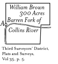
A Tract of Land in
Warren County Tennessee
A Survey for William Brown
Third Surveyors’ District
1808
Transcribed by Fred Smoot
 State of Tennessee }
Third District } Surveyed the 27th day of April 1808 for William Brown his prefference right of three hundred acres agreeable to an Act of the General Assembly passed at Knoxville the 3rd day of December 1807 Situate in the County of Warren on both sides of the barren Fork of Collins river Beginning on a black oak on the North Bank of said river thence North one hundred & thirty poles to a black oak & hickory then East two hundred & forty poles to a white oak then South one hundred and twenty two poles to a black walnut tree on the Bank of the river a condition line between Walter M. Donal [or Daniel] and Said Brown thence with the condition West Fifty Two poles to a stake thence South five degrees west one Hundred poles to a hickory and a post Oak the west one hundred & eighty poles to a stake in the Barren Fork of Collins River then North Ninety Two poles to the Beginning. Jno. A. Wilson D.S.
David Brown } Wm Brown Junr } Chrs. Sent to the register Feby 24th 1814 [Sidebar] Part of a Certificate No.53 issued by the Register of West Tennessee applied to the claim & entered on the 7th day of August 1811 by No.1475 entered in the name of Thomas Vaughan. TSLA RG50 Microfilm Roll 35 Tennessee Land Records Third Surveyors’ District, Vol 35, p. 5. |
Red Banks Main Page
This page last updated on