The plats and surveys on this page were extracted from Book, 34 Plats and Surveys, 3rd Surveyors District, 1807-1814. There are 357 pages of un-numbered surveys in that book. Many are from older and greater Warren County. Only a few are published herein.
The small Plat graphics were made from photocopies which were made from the microfilm of the original Plats. Hence the generally poor quality of the graphics. Original spelling and punctuation were closely followed in this transcription.
The names of the applicant for survey are:
David Brown, Page 47.
Joseph Burlason, Page 33.
Aaron Burlison, heirs of, Page 347
Moses Burlison, Page 347
Nimrod Dodson, Page 104
Redman McMahon, Page 48.
William C. Smart, Page 31.
William C. Smart, Page 43.
Thomas Vaughn, Page 357
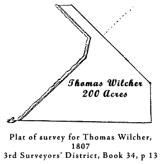
Thomas Wilcher, Page 13.
Extracted from Book 34, Plats and Surveys,
3rd Surveyors' District
Tennessee Library And Archives
Tennessee Land Records - Record Group 50, Series 3
Microfilm 35
Page 13.
State of Tennessee Third District ~ Surveyed the Second day of October one thousand eight hundred and Seven for Thomas Wilcher ( assee. of Wm. P. Anderson who is of John Nelson ) two hundred acres of land by virtue of part of a Duplicate warrant issued by John Armstrong entry taker the tenth day of July Seventeen hundred & eighty four No. eleven hundred & twenty for Five thousand acres leaving a ballance of Said warrant yet to be Satisfied of four thousand eight hundred acres located the thirty first of August eighteen hundred and seven located No. two hundred and Seventy one Situate in the county of White in the thirty fourth section of Said district beginning on two hackberries and a Sycamore on John Millenders north boundary line eighty poles west of his north east corner thence running east two hundred and Seventy poles to a Stake thence north eighty poles to a black poplar & white oak it being his beginning corner of entry location No. two hundred and one thence north forty five' west along line of location No. two hundred and one & two; two hundred and twenty poles to two dogwoods thence west Sixty Six poles to a Spanish oak on bank of barren fork of Collins river thence up Said river South forty five east ninety two poles thence South fifteen west forty four poles then South forty five west one hundred & eighty two poles to the beginning ~
A. Higginbotham D.S.
Joseph England &
H. Hearly, C. C.
Sent to the Register
Page 31.
State of Tennessee Third District ~ Surveyed the 23rd day of January 1808 for William C. Smart assee. of William P. Anderson who is of John Nelson his preference right of two hundred acres of land by virtue of part of a Warrant No.1120 for five thousand acres leaving a balance of said warrant yet to be Satisfied of 3657 acres located the 28th day of August 1897 location No. 190 Situate in the County of Warren in the 34 Section of Said district beginning on a black oak on the west bank of hickory creek of the barren fork of Collins river thence north Seventy five degrees west one hundred & Sixty eight poles with a conditional line between William Campbell & Said Smart to a hickory then north ninety Seven poles to a black oak near a Small branch a condition between Samuel Priest & Said Smart thence with the condition north eighty degrees east eighty eight poles then South eighty degrees east Sixty poles then South Sixty degrees east fifty two poles then east forty two poles to an elm on the west bank of hickory creek a condition between William Priest & Said Smart thence with the condition South twenty five degrees east twenty four poles then east twenty poles then north Seventy degrees east Sixty poles then South eighty Six poles then west one hundred __ forty ____ [ink blots] poles thence South thirty three degrees west twenty eight poles to the beginning ~
Jno. A. Wilson D.S.
James Priest &
Geo. R. Smart, Chrs.
Sent to Registers Office 15th Feby - 1809
Page 33.
State of Tennessee Third District ~ Surveyed the 17th day of November 1807 for Joseph Burlason (assee. of John Armstrong ) one hundred & eighty five acres of land not having Sufficient bounds within the calls of location to Satisfy an entry made by Said Joseph Burlason for two hundred acres by virtue of a military warrant No. 5094 for 1000 acres located the 25th day of August 1807 location No. 82 Situate in the county of White in the 40th Section of Said district. beginning on beach & running north with mountain a natural boundary Seventy four [degrees] east one hundred & Seventy Six poles to Ash and buckeye thence north one & four poles to hickory thence west two hundred & Sixty Four poles to dogwood & elm from thence to the beginning. ~
A. Higginbotham D.S.
Gabriel Long &
Archelus Nunley, C. C.
[ Note: Section 40, White County located now Warren County, Hickory Creek area. ]
Page 43.
State of Tennessee Third District ~ Surveyed the twenty fifth day of February eighteen hundred and eight for William C. Smart (assignee of William P. Anderson who is of John Nelson) one hundred and forty three acres of land his right of preference as assignee of William Campbell by virtue of part of warrant eleven hundred & twenty issued by John Armstrong entry taker for five thousand acres leaving a ballance of Said warrt. yet to be Satified of three thousand eight and fifty seven acres located the twenty eighth day of August eighteen hundred and Seven location No. one hundred and ninety one Situate in the county of Warren in the fortieth sec. of said district. beginning on post oak and pointers and running South one hundred and twenty poles to pointers ( having crossed line of John Tollivers Survey location No. one hundred & forty nine ( it being eight poles west of his north east corner ) at the end of twenty poles also in Sixth out crossed hickory creek rung. [running] to left thence east two hundred and twenty poles to dogwood & pointers having crossed hickory creek at the end of forty poles rung. to right also came to it in eighth __________ to the end of one hundred & ninety poles, thence north one hundred & Sixteen poles to Sycamore on bank of creek on line of his entry location No. one hundred & ninety thence up Said creek with Said line west Sixty poles thence South thirty three west twenty eight poles to his beginning corner black oak (of Said entry) thence on with Said line north Seventy five west one hundred & forty eight poles to the beginning. ~
A. Higginbotham, D.S.
James McDaniel &
Charles McLain, C. C.
Sent to the Register 15th of February 1807
Page 47.
---run to the cardinal points
State of Tennessee Third District ~ Surveyed the 22nd day of April 1808 for David Brown Assee of William P. Anderson his occupant claim of two hundred acres by virtue of part of a warrant No. 1120 for 5000 acres leaving a ballance of said warrant yet to be satisfied of _____ [omitted] acres located the 31st day of August 1807 location No. 254 Situate in the county of Warren in the 34th Section of said district beginning on two black oaks one of them marked D.B. thence South one hundred & Seventy eight & eight tenths poles to a poplar thence east one hundred Seventy eight & eight tenths poles to a Stake in the barren fork of collins river then north one hundred Seventy eight and eight tenths poles to a white oak & black gum on the west bank of the river then one hundred Seventy eight & eight tenths poles to the beginning. ~
John A Wilson D.S.
Samuel Colville
George Bradley, Chs.
Sent to the Register the 16th of Feby. 1809
Page 48.
State of Tennessee Third District ~ Surveyed the twentieth day of May eighteen hundred and eight for Redman McMahon ( assee. of John Barrow ) two hundred acres of land by virtue of part of a military warrant No. 47 for 228 acres leaving a ballance of Said warrant yet to be Satisfied of 28 acres located the 19th day of May eighteen hundred & eight location No. 494 Situate in county of Warren in the thirty fourth Section of Said district beginning on post oak & persimmon on the north bank barron fork collins river opposite the mouth of hickory creek running thence north twenty five east down the river eighty poles to Spanish oak thence on one hundred poles to rock in the river thence west one hundred & twenty four poles to dogwood thence South fifty four poles to pointers thence west Seventy four poles to black oak thence South one hundred & eighteen poles to elm on bank of river on condition with Cowen thence down the river South forty five east forty five poles thence South eighty two east twenty Six poles thence with Seventy Six east thirty Six poles thence north Seventy three east one hundred & fourteen poles to the beginning. ~
A. Higginbotham D.S.
Sanders McMahan &
James McMahan
Page 104.
State of Tennessee Third District ~ Surveyed the 30th day of August 1808 for Nimrod Dodson assnee. of Elijah Chisum One hundred & Ninety Acres of land , by virtue of Part of a Warrant No.315 for 640 Acres ( which interferes with a Prior entry of L____ Gray's as appears in the above Plat, said Dodson is entitled to forty One & one half Acres of his Warrant it being the interfering Part as stated above ) located August the 27th 1807, location No.152, Situate in the County of Warren in the 40th Section of said District beginning on a Stake in a barren on the line which divides the 2nd & 3rd District where the North boundary of E. Chisms five thousand Acre Survey intersects the Same, thence East with said Chisms line two hundred & forty six Poles to a Sweet gum, thence North One hundred & twenty three & One half Poles to a red Oak & White Oak, thence West two hundred & forty six Poles to a Stake in a field, thence South One hundred & twenty three & one half Poles to the beginning; Surveyed by ~
Jno. A. Willson
Thomas Gray &
Matthew Gray, Chrs.
( Granted )
Page 347. Sent out by Moses Burleson May the 11th 1815 ~
State of Tennessee Third District ~ Surveyed the 21st day of March 1814 for Moses Burlison assignee of Danl. Payne Eighty acres of land By virtue of part of Warrant No.163 located the 4th of Nov 1811. Location 1574 Situate in the County of Warren and Said District on the Waters of Collins river ~ Begg. on a Chinquapin oak & running North with the mountain 60 poles to Pointers thence again North 10' East 53 Poles to Pointers thence West leaving the mountain 118 Poles to hickory thence south 113 Poles to post oak thence East to the Beging ~
A. Higginbotham D.S.
Randol Edwards &
Jonas Edwards, S. C. C.
Page 347. Sent out by Moses Burlison May 11th 1815 ~
State of Tennessee Third District ~ Surveyed the 21st day of March 1814 for the heirs of Aaron Burlison assee of [blank] fifty an [?] acres of land By Virtue of part of Certificate No.1427 locate the 28th day of July 1812 Location No. 1863 Situate lying & being in the County of Warren and Said District on the Waters of Collins River adjoining Phillip Hoover Beging on a forked Chestnut on said Hoover line & running north passing his N. W. corner 89 1/2 poles to a black oak thence West 89 1/2 poles to white oak thence south 89 1/2 poles to hickory. thence East 89 1/2 poles to the Begg. ~
Survey. A. Higginbotham D.S.
Randol Edwards &
James Edwards, S. C. C.
Page 357.
State of Tennessee Third District ~ Surveyed on the 2nd day of Apr 1814 f____ [missing, torn] Thos. Vaughan assignee of Pleasant Hend [missing-torn, should be Henderson] Three acres of land By Virtue of part of a Certificate No. ____ [missing-torn] Located The 24th day of Feby 1814 Location No.2924 situa__ lying & being in Warren County in said District near to the eastern boundary of the 2nd District on the waters of the barren fork of Collins river adjoining William Browns occupant survy Begg. on a black Oak ( Now dead ) on his line it being northeast wd. from the spring that Isaac Anderson makes use of & running West 24 poles to stake & pointers thence South 20 poles to post oak thence east 24 poles to stake on sd. Wm Browns line thence with his line north 20 poles to the Beginning ~
A Higginbotham D.S
Thomas Brown
William Brown, C. C.
Sent out ___ Geo D Staton 12 Aug 181_