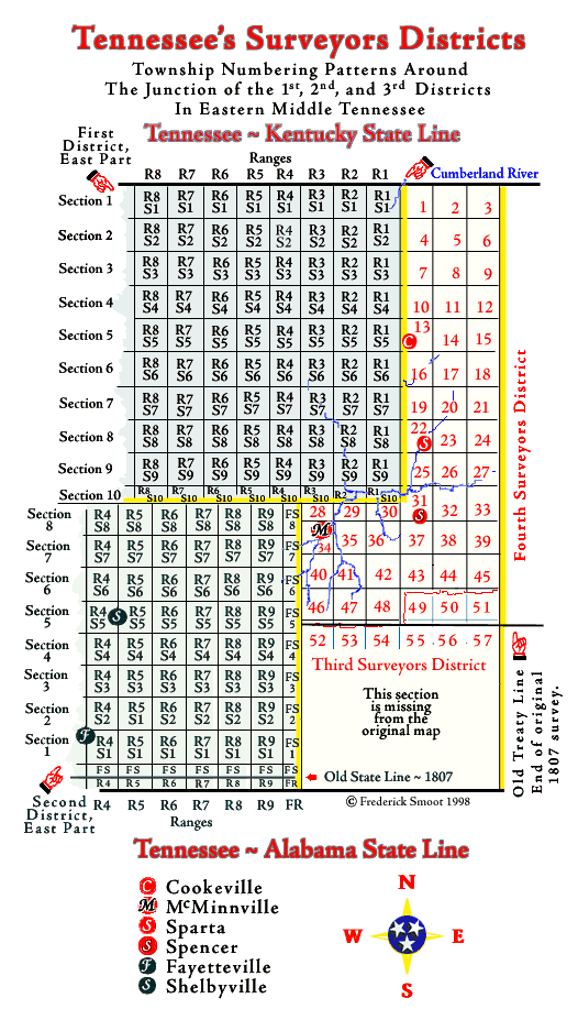
Tennessee’s Surveyors Districts
Township Numbering Patterns Around
The Junction of the 1st, 2nd, and 3rd Districts
in Eastern Middle Tennessee
© Frederick Smoot, 1998
~ 1807 ~
INTRODUCTION
The authority for the 1st and 3rd District areas represented on my map
are the two extant original District maps held by TSLA. (1st District,
TSLA map #401, 3rd District, TSLA map #399.) Those two maps were
closely followed.
There is no extant original 2nd District map, therefore the placement of
the townships is based on the entry of over 2,000 early original 2nd
District survey descriptions into a database and then sorting them by
Range and Section numbers and then matching those numbers to the common
physical landmarks in the various townships.
Additionally, certain "proof" is offered by some "Survey Notes, 1807,"
(TSLA Microfilm roll AC-1511). This microfilm shows some original,
single, straight line surveys done in 1807 when the 2nd District was
first surveyed.
Also, I find that my research is proven by the map work done by the
noted Tennessee historian, Timothy R. Marsh. You will find a nice little
map showing township lines for Bedford County in his Land Deed
Genealogy of Bedford County Tennessee and another map of a slightly
lager area in his Land Deed Genealogy of Lincoln County Tennessee. I
used Mr. Marsh's maps for my placement of Fayetteville and Shelbyville.
Please consider that most of the area covered by this map was Cherokee country
until January 1806. The towns came later.