Cemeteries from Book 2The cemeteries listed below have been copied from the Warren County, Tennessee Cemetery Books (Vols 1, 2, 3, & 4) by Mrs. Almetia Cunningham and Mrs. Martha Holt, edited and complied by Mrs. Betty Moore Majors. This listing is used here with the kind permission of Betty Majors.
Our purpose here is to first list the cemeteries from the books (this part is finished), then to add to the list the various cemetery locations as found in the books. Along the way, if we are able to refine the location information, we will add a map or small page with cemetery information.
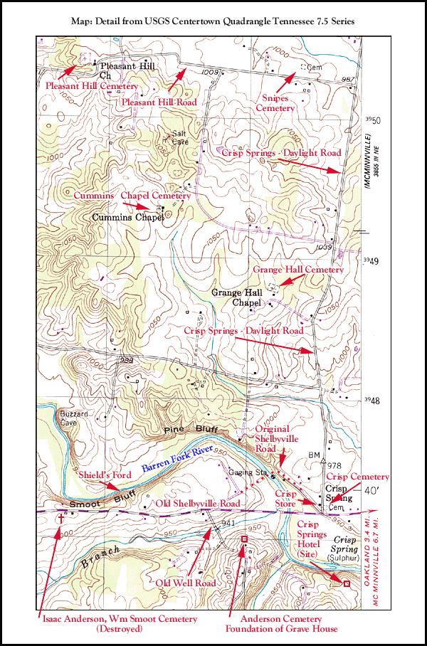
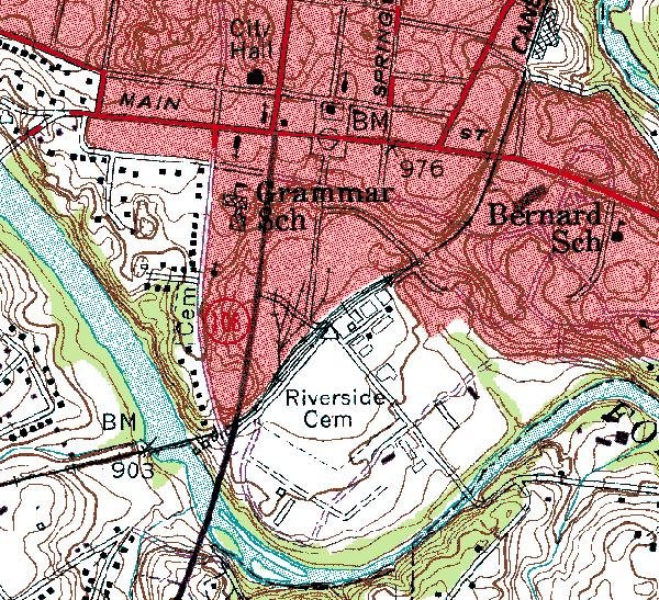
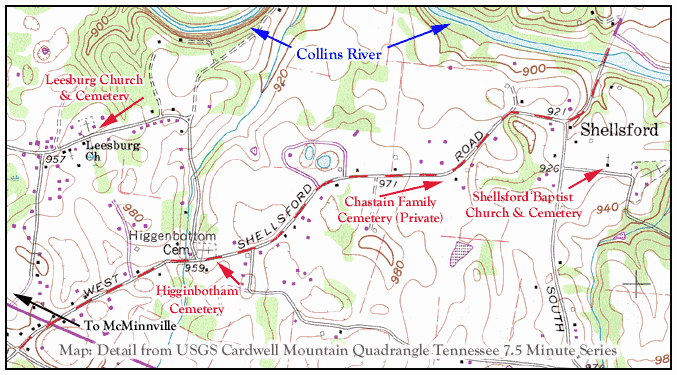
If it at all possible, our maps will locate the cemeteries on small portions of USGS 7.5 minute series maps. We will also give the cemetery locations in Latitude/Longitude (degrees, minutes, seconds), i.e. 35° 39' 54"N. The USGS maps do not often name the roads so we will use the road names from the Tennessee Atlas & Gazetter, published by Delorme. That atlas is currently available and is a “must have” for every Tennessee researcher. Please note that like the rest of America, Warren County adopted the 911 emergency phone system and at that time, many roads received new names and road signs. Often the new road names were named for more modern residents.
We recommend the four books which include many annotations. Book I (A thru F) encludes about 5500 burials -17,000 names, including many parents, wives and women’s maiden names. The other books, Vols 2, 3, & 4, are simular. In the books, the cemeteries are listed alphabetically by name of cemetery and all names are extensively indexed.
We appologize for the size of some of the maps, however readability is more important than download times.
Warren County and its Cemeteries
Originally, Warren County was much larger than it is today. Therefore, some early Warren County pioneers who appear in early Warren records may have been buried in areas of the counties which formed from Warren between 1836 and 1842. Those counties are Cannon, Coffee, DeKalb, Grundy, and Van Buren. The cemeteries listed below are in modern Warren County and adjoining counties.
Most early Warren grave markers have disappeared and so have many of the early cemeteries. The poor quality of the native stone like limestone, used for grave markers, was prone to erosion. A grave marker that had fallen face down would decompose from both sides, that is, weather erosion from the top, contact erosion from wet ground below. In the early days, burial on the family farm was common, near the farm house, often on a knoll, or even occasionally in a fence row. Most of Warren’s earliest burying places are gone. Of course, the bulldozer has also taken its toll of the old cemeteries.
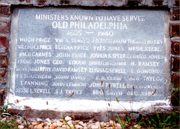
Even early church cemeteries have lost some of their graves. Examples; French Cemetery has lost most of its graves; Old Philadelphia has lost perhaps two hundred graves. Graves of African-American slaves were the first to go. Those graves would have had the poorest of grave markers if they had any at all.
Lastly, tombstone photographs are being added to cemeteries as they are received. Also included are some new old cemeteries that are not found in the cemetery books.
Cemeteries from Book 1
Adcock Cemetery
Schrock’s store to Belk Community, on Orville Moore’s Farm
Isaac Anderson’s: 35° 39' 54"N, -85° 53' 54"W
Anderson Grave House Ruins: 35° 39' 48"N, -85° 53' 03"W
35° 34' 32"N -85° 44' 13"W
On Northcutt’s Road at Armstrong Church of Christ, Irving College area
35° 46' 05" N, -85° 40' 11" W
In Vervilla Community behind home of Dave Herron
On Jack West farm near Cherry Springs Road
Near Lucky, back side of Herbert Bond’s farm
Hill's Creek area of Irving College
35° 35' 46" N, -85° 52' 09" W
Vervilla Community at Bascom Methodist Church
35° 42' 26" N -85° 51' 13" W
Hwy 70S, 4 miles west of McMinnville on right side of road.
35° 44' 23"N -85° 49' 10"W
Yager Rd. across from Bethlehem Presbyterian Church
35° 43' 45" N -85° 42' 38" W
35° 32' 23" N -85° 51' 28" W
35° 43' 55" N, -85° 45' 38" W
Off site with a return to Warren County
35° 45' 30"N, -85° 41' 03"W
On the right just past Jericho Church on Hennessee Bridge Rd. and Hwy 288
off of Old Rock Island Rd. at Mud Creek.
Isaac Brown, 35° 39' 41" N, -85° 51' 44" W
Wm “Devil Bill” Brown, 35° 40' 13"N, -85° 51' 13"W
35° 41' 04" N, -85° 53' 25" W
35° 45' 15" N -85° 45' 21" W
35° 46' 21" N -85° 38' 10" W
Depot Rd., Campaign, TN
35° 38' 37"N -85° 56' 10"W
35° 49' 24"N -85° 42' 36"W
35° 43'37"N -85° 55' 23"W
35° 45' 24"N -85° 51' 49"W
35° 40' 14"N, -85° 43' 00"W
35° 46' 14"N, -85° 44' 55"W
35° 39' 55"N, -85° 52' 40"W
35° 41' 03"N -85° 53' 24"W
35° 48' 29"N -85° 38' 08"W
Also known as the Cunningham-Gribble Cemetery, Rock Island State Park
35° 48' 55" N -85° 51' 30" W
35° 35' 53" N -85° 55' 41" W
35° 43' 42"N, -85° 37' 18"W
35° 42' 48"N, -85° 46' 07"W
35° 40' 12"N, -85° 55' 36"W
35° 46' 15"N -85° 37' 26"W
Friendship Circle off Old Rock Island Rd., Campaign, TN
35° 46' 16" N -85° 47' 53" W
35° 41' 50" N -85° 45' 38" W
Cemeteries from Book 3
35° 38' 18" N -85° 50' 27" W
Hwy. 55, Smartts Station, TN
35° 43' 22"N -85° 45' 25"W
35° 46'48" N -85° 47' 32" W
Hwy. 56 toward Smithville, TN
35° 40' 46"N, -85° 52' 54"W
35° 44' 33"N -85° 44' 31"W
35 35' 18" N -85 43' 35" W
35° 44' 36"N -85° 50' 17"W
35° 40' 04"N -85° 43' 43"W
35° 33' 39"N -85° 38' 46"W
35° 41' 05" N -85° 48' 33" W
35° 44' 29"N -85° 58' 00"W
West of US 70 Hwy. at the crossroads just before the Cannon County line.
Early Death Records of Ivy Bluff Church of Christ can be seen on this Cannon County site.
You will need to use your BACK button to return here.
35° 40' 09" N -85° 56' 56" W
35° 48' 08" N -85° 45' 013" W
Faulkner Springs Rd., L. at stop onto Bluff Springs Rd. to Highland Rd.
to A.J. Cooper Rd. The first house on the left is the property where the
cemetery is located.
See, also, Jaco Cemetery in Book 4, below.
35° 45' 04"N -85° 51' 01"W
35° 40' 21"N -85° 44' 03"W
35° 39' 38"W -85° 47 38"W
Cemeteries from Book 4
35° 41' 48" N -85° 44' 56" W
35° 43' 45" N, -85° 42' 38" W
35° 35' 21"N -85° 55' 02"W
35° 35' 41"N -85° 39' 09"W
35° 44' 22"N, -85° 38' 18"W
35° 42' 43"N, -85° 41' 37"W
35° 41' 46"N, -85° 45' 58"W
35° 34' 11"N, -85° 49' 14"W
Additional Cemeteries in Book 4
Pleasant Cove Cemetery, on the old Crain farm.
35° 47' 33"N, 85° 41' 55"W
Off Hennessee Bridge Road at New Bybee Chapel Methodist Church.
On the left off McCollum Bend Road, just after crossing railroad tracts.
35° 43' 53"N -85° 35' 52"W
Just off Hwy. 30 near Van Buren County line.
35° 42' 41"N -85° 41' 43"W
On Hwy 30 at New Union Methodist Church.
35° 42’ 01”N -85° 57’ 48”W
At Oak Grove Baptist Church.
35° 49' 56" N -85° 50' 30" W
At Oak Grove Church of Christ on Oak Grove Rd. off W. Green Hills Rd.
35° 47' 39"N, -85° 40' 49"W
Off Hennessee Bridge Road on Old Bybee Road.
35° 40' 40"N, -85° 46' 34"W
Corner of S. High and George Hudgins streets, McMinnville, TN.
Off site, use your BACK button to return here.
On Ramsey Boyd place, Highland Community
Left at Centertown Church on the Old Bower (Brewer) property.
35° 35' 29"N, -85° 52' 16"W
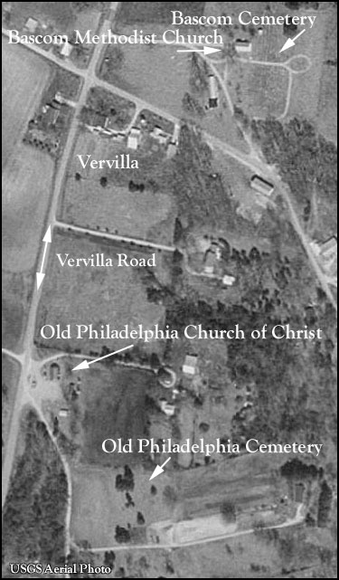
At Vervilla near Philadelphia Church of Christ.
Off Rocky River Road near Van Buren County line,
3 miles off Hwy 8 on Long Mountain Road
“Twelve miles below Rock Island” as mentioned in the Southern Standard, 1938.
35° 47' 01"N, -85° 37' 38"W
35° 41' 39"N, -85° 53' 48"W
35° 48' 02"N -85° 49' 58"W
35° 40' 37"N, -85° 46' 22"W
Bridge Street in Depot Bottom, McMinnville, TN.
GPS 35° 35' 38 N" -85° 49' 05 W"
35° 47' 52"N, -85° 36' 57"W
From Highway 70 South, turn off at the 24 mile marker onto Highway 136 North.
Travel 1.2 miles and turn left at the 287 Junction. Travel four tenths of a mile and
the cemetery will be on the left. Partial listing of burials.
35° 45' 14"N, -85° 45' 01"W
On Salem Rd. off Francis Ferry Rd.
35° 40' 16"N, -85° 42' 31"W
35°44'39"N -85°56'36"W Irving College area.
35° 43' 57"N, -85° 40' 29"W
On Old Rock Island Rd. at Mud Creek.
35° 38' 00" N -85° 42' 20" W
This cemetery is not listed in the cemetery books.
35° 35' 15"N -85° 53' 48"W
35° 41' 46"N, -85° 46' 00"W
N. Spring Street, across from Mt. View Cemetery, McMinnville, TN
35° 44’ 48”N -85° 53’ 29”W
35° 45' 54"N -85° 44' 46"W
Newly located cemetery not found in the Warren County Cemetery Books
35° 32' 57" N -85° 51' 38" W
35° 49' 2"N -85° 45' 52"W
35° 43' 36"N -85° 56' 24"W
35° 38' 05"N -85° 55' 26"W
Newly located cemetery not found in the Warren County Cemetery Books
35° 50' 10" N -85° 49' 19" W
near Oak Grove Church of Christ, Dibrell area
35° 50' 48"N -85° 50' 09"W
35° 44' 39" N -85° 56' 32" W
Cemeteries just across the county line, but of interest to Warren County researchers
35ş 48' 07" N -85ş 37' 38" W
Rock Island State Park
Of the five (5) cemeteries at the Park beside the two Cunningham cemeteries,
there are three (3) that are nameless and only contain four (4) identifications.
35° 47' 35" N -85° 39' 36" On Gerald Grissom Farm, Flat Shoals Rd., north of Campaign.
35ş 30' 12" N, -85ş 52' 37" W Three (3) miles south of Viola on Hwy. 108.
The cemetery and church are in Coffee County and about 25 yards from them
are the Cook House, the Community House and the Pavilion in Grundy County.
The north side of the cemetery grounds abuts the Warren County line.
This page last updated on March 24, 2013.