By Estelle Hall
Joseph B. Johns and wife Elizabeth Vaugh(a)n are buried on property sold
by Ernest Johns(descendant of Joseph) to Jack Lane in 1962 located at end
of Lane Rd. off Dunnaways Chapel Rd off Jefferson Pike going toward Lascassas
from Walter Hill intersection of 266 and 231 No. of Murfreesboro, TN.
in corner of lot behind old home place. (Source: Estelle Hall has seen
the graves. These graves are not where they are reported to be in several
books located in the library at Murfreesboro, TN or on the map of Rutherford
Co.)
Inscription from the markers for Joseph B. Johns and his wife Elizabeth
Vaughn Johns.
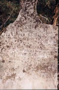
Sacred
to the memory of
Joseph B. Johns
who departed this life
November 8, 1839
Aged 63 years
9 months
10 days
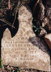
Sacred
to the memory of
Elizabeth Johns
who departed this life
May 26, 1844
aged 65 years
9 months
17 days.
Joseph B. Johns settled in Tennessee in 1801. He lived briefly in Giles
Co.,
TN and then settled in Rutherford Co., TN. He served in the War of 1812.
He enlisted 10 Dec 1812 and served as a private Captain Newtons Co., Col.
Wm. Halls Regiment of West TN Militia 12-10-1812; and private in Capt.
Nathan Davis' Co. in Regt. under Gen. Andrew Jackson, 12-18-1813.
He purchased land on E. Fork Stones River and at his death owned
about 1,000 acres.
This grave site is located on private property. There are 3 stones.
One without engraving is broken in many pieces. The two with the
inscription are broken from their base but the inscription part is
intact. They were laying on the ground covered by weeds. They are
currently leaning against a fence. It is incorrectly listed in several
publications as being west of Walter Hill on 266. The descriptions
incorrectly put it on property that was owned by my grandfather Will
Boone Johns. With the help of Ernest King Johns and my uncle Hascal
Johns I was able to locate the site of the graves off 266 East.
Traveling from Murfreesboro, TN on 231 No. Travel about 10 miles
to the intersection of 231 and 266 at the Walter Hill intersection.
Take a right onto 266 East towards Lascassas. Travel 2.1 miles to
Dunnaway Chapel Rd.(Kings Chapel Baptist Chruch). Take a left and
travel 1.3 miles to Lane Rd. Take a left on Lane Rd. and travel
.06 mile to bridge over creek. The graves are located approx. 300-400 yds.
N.W. in the corner of a fence line behind the old home. The land was owned
by a Johns descendant until the 1960s when it was sold to Jack Lane. (Joseph
B. Johns ggrandson Earnest Johns) There is a new brick home built on the property
and the old house is scheduled to be torn down spring 2001. Standing at the
bridge looking toward the new home the grave sites are approx 100 yds. to
the right.