Nickajack Cave
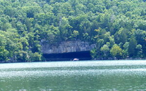
This cave currently is flooded by Nickajack Lake. The water area in the photo once was dry land on a farm. In the 1960’s I remember finding arrowheads all around in front of the cave. This was the site of some of Marion County’s first residents- Cherokee (or the branch called Chickamauga) Indians. It was the Nickajack Indian Settlement, and it seems several Indians from there assimilated into the “white man’s” world and are ancestors of some of the present-day surnames of Marion County. Proving that for any one individual is not always possible, but there is at least one incidence of a family Bible record making the statement, and stories abound in the family lore of several families passed down through the generations.
Before the cave was flooded by the new lake, there was a creek coming out of the cave, running to the Tennessee River. There was dry ground inside the cave, however. Now the cave is flooded and has a fence across it’s opening to keep boaters and all others out, since a protected species of bat was found living in the cave. This is located on State Highway 156, between New Hope and Ladd’s Cove near Nickajack Dam. The cave is in the civil district known as Shellmound, but Shellmound is on both sides of the Tennessee River and Nickajack Lake. I think it fitting that this photo be the first one on this “genealogy” page of the places in Marion County.
This cave is on the south side of Nickajack Lake between New Hope and Ladd’s Cove at the foot of Sand Mountain on TN State Highway 156. The Highway to Bryant, AL and Macedonia Road both begin at highway 156, and are on each side of the Cave area. The Alabama state line is on Sand Mountain no more than .5 mile behind the cave. The Georgia/Alabama/Tennessee corner is less than 1 mile southeast of the cave.