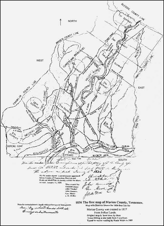
MARION COUNTY, TENNESSEE
1836 Plat Map and Civil District Descriptions
BOUNDARIES of MARION COUNTY, TN in 1836
Marion County as originally laid out was bounded west by Franklin, Co., north by Warren and
Bledsoe Co., east by what is now Hamilton and south by state lines of Georgia and Alabama.
Sequatchie County, Grundy County, and portions of White and Franklin Counties were then part
of Marion County, TN.
The map below is not a copy of the original. It was altered by Nonie Webb. The text on the
original was hand written, but the map was cleared of that and all the detail by her and the
text was then typed. This version is small, blurred and missing details such as the actual
district boundary lines and the locations of the election polls. It is OK for a quick look,
but I have obtained a copy of the original from the Tennessee State Library and Archives,
and you can
Below is a transcription of the original written description of the 10 districts as worded by
the commissioners who partitioned the districts. A photocopy of the original of this document
is also viewable on this site to enable you to see the actual wording of the original. There
was a transcription here previously from 1998 to 2015 that was very badly riddled with errors,
so much that the boundaries made no sense and the wording became useless. I have tossed that
and replaced it with the following, and an image of the original can be viewed as proof.
Justices Districts In Marion County
We the undersigned commissioners who were appointed to lay off Marion County into Justices
Districts Beg leave beg leave [sic] to Submit the following (viz)
1st District:
Bounded on the north by the Bledsoe County line, north west by Warren County on the East by
Hamilton County and on the south by a direct line from Gnl Stones Spring branch to
Isaac Martins Camp ground near the foot of Waldens Ridge, thence a direct line to Hamilton
County and from the ford of said Gnl Stones baach [sic] to the Warren County line
Northwardly.
The Election precinct to be at the former Muster Ground of Capt Bunch's Company.
2d District:
Bounded on the north East by the 1st district, on the west by Warren County, on the East by
Hamilton County, and on the south by the dry creek property near Henry Tatums house, and with
said creek to Sequatchee river and up said River to Condras Mill Creek Thence up said Creek to it's head; thence eastwardly to
its head thence Eastwardly to Hamilton County line and from the head of said Tatums Creek to
Warren County line.
The Election to be at the Residence of Nathaniel Langly.
3d District:
Bounded North by the 2d Dist on the west by Warren County, on the east by Hamilton
County, and South by a line beginning at David Chandon Jrs Cave Spring thence a direct line
to the Widdow Newman's near the foot of Walden's Ridge so as to include said (blurred), thence a direct line to Suck Creek so as
to include said Widow Thence a direct line to Suck creek so as to Include James Andersons
premises, and from the said Chandoin Spring to the top of Cumberland Mountain Thence to the
county line so as not to include the Inhabitants on the head waters of little Sequachee
The precinct of the Election at the residence of David Griffith
4th District
Lying north west of Sequachee River-- Bounded North by the 3d
District and from the point where said line of the 3d District Intersects said River
Thence down Said River to a Bluff opposite the residence of the late Matthew Pryor Esq and from
said Bluff thence along the Eastward height of the Ridge to the Copland Ford on little Sequachee
Thence up said Creek to the mouth of L. Hendrix Spring Branch and up it to the spring Thence to
the top of the mountain Thence near the double Cabbins on Higgonbottom Trace so as not to
Include Said Cabbins Thence Northwardly to the County line Thence With Said line to the 3
d District, so as to include all the Inhabitants of the water of little Sequachee
and with Said line to the Beginning
Election precinct at the Residence of Jonathan Blevins
5th District
Beginning at Copelands Ford and running with the line of the 4th District to the
point whare whare [sic] it Intersects Sequachee River Thence Eastwardly with the 3rd
District line to the top of Waldens Ridge Thence to the fork of Mullen Creek near the Old ford
leading to the Suck; Thence Westwardly between Oalts[?] Gin Houes [sic- House] and Roddin with
the Mountain Branch to the Tennessee River thence down Said River to the bluff of the Cedar
Mountain Thence across Said Mountain So as to Include John Hoge and A. Kellys plantation and a
direct from said Kellys to the mouth of the Little Sequachee and up it to the Beginning
Election precinct at the House of Archibald Lomis.
6th District
Beginning at the fork of Mullens Creek and running with the Third District line so as to
Include all the territory on the Mountain above said Creek not included in the third district
to Hamilton County line with said county line to the Georgia line Thence along said line to
whare [sic] the road from Jasper by Belshers ferry Crosses the extreme height of the Raccoon
Mountain Thence Northwardly to the Tennessee River near the lower point of the Island so as to
include Green [Greer?] Woodlees improvement Thence up the river Including the Island to the
Mountain branch aforesaid on Ct Oalts land thence with the line of the 5th
Dist to the Beginning.
Election precinct to be at the House of Pleasant McBride
7th District
Beginning at the bluff of the Cedar Mountain on the Tennessee River and
running down the river to Lowery's old Landing Thence a direct line to the forks of the road
leading up Battle Creek and to Rices ferry and to Rices ferry [sic- phrase repeated] on said
Creek and from the fork of said road to the Top of the mountain Thence Northwardly so as to
include the double Cabbins [sic]] on Higgenbotham Land [?] and thence to the line of the
4th District and with the line of the 5th District to Tennessee River to
the Cedar Bluff at the Beginning
Election for this dist to be held In Jasper
8th District
Beginning on the south of the Tennessee River with the line of the 6th Dist and
running with said line to the Georgia State line including all the territory below said line
on the south side of the Tennessee river to the Georgia and Alabama lines and with the state
line across the Tennessee River to the top of the Mountains at the head of Kings Cove Thence
Eastwardly with the main dividing ridge between Sweetons Cove and King's Cove to the bluff of
the mountain near Rice's ferry on Battle Creek Thence to the fork of the Road near G W Rices
fence, thence with the line of the 7th Dist to the Beginning
The Election for this district to be held at the House of Andrew Cannon
9th District
Beginning at the fork of the road leading up Battle Creek and Rices ferry and Running with the
line of the 8th District by said ferry to the State line at the head of Kings Cove
thence with the said line to Franklin County line thence with the said line to the Franklin
County line thence with said line to Harris Turnpike road Thence with said road to Battle Creek
Thence down said creek to the fish trap ford Thence Eastwardly to the top of the Mountain
above John Hices Thence along the meanders of the mountains to the line of the 7th
Dist on the top of the mountain and thence with said line to the Beginning
Election in and for this district to be held at the house of Frances M. Delaney.
10th District
Beginning on the Franklin County line whare [sic] Harris Turnpike Road intersects said line
Thence to the line of the 9th Dist to the point on the top of the mountain above
said Hices whare [sic] the line of the 9th District intersects the line of the
7th District and with the line of the 7th District northwardly to the
line of the 4th District Thence with the line of the said 4th District
to the line of the County Thence with the line of the County to the beginning
The elections for this district to be held at the House of William Champion
State of Tennessee
Marion County
We the undersigned commissioners appointed to lay off said county into districts within which
justices of the peace and constables shall be elected, after being sworn as required by law,
proceeded to lay off said county into ten districts according to the enumeration of 1833 which
said county is entitled to, and we do certify that the foregoing districts as numbered is a
complete record of said districts as by us laid off.
Given under our hands this 16th day of January 1836.
John Mitchell
John Bennett
Obadiah Beene
Geo. Moore
J. M. McBee
Transcribed by David Johnson on 01/11/2015; update based on contribution from S. Hendrix by Taneya Koonce on 4/15/16.