Bradford 1835 Atlas


A TNGenWeb History Project

Welcome!
Thomas Gamaliel Bradford of Boston Massachusetts published two Atlases. The first, smaller edition appeared in 1835, and the larger edition was published in 1838. Our maps are from various copies of the 1835 Atlases, those that have been broken sometime in the past. As we find them, we will publish more of these little maps.

To see the large version of these maps, Click the Link under the thumbnail graphic of each map. These large maps require long download times. If you find a map that you might use often, consider saving the map file to a disk or to your hard drive.


KY/TN 

1835 Map
Click Here


Tennessee and Kentucky, 1835. (311k)
Note the Cherokee Lands still intact in the southeastern corner.


LA, AR map

(1835)
Click Here

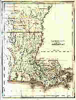
Lousiana and part of Arkansas, 1835. (184k)


MS-AL  

1835 Map
Click Here

Misissippi, and Alabama 1835 (333k)
Map shows Indian land.
Cherokee, Chickasaw, and Upper Creek


NC/SC/GA 1835

Map
Click Here

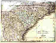
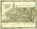
North & South Carolina and Georgia, 1835. (213k)


PA~NJ  

1835 Map
Click Here

Pennsylvania, New Jersey, 1835. (293k)


VA~MD~DE 

1835 Map
Click Here

Virginia, Maryland, and Delaware, 1835, (185k)
What was later to become West Virginia is shown as Virginia on this map.


From the collection of Fred Smoot


TNGenWeb
Main Maps Page.


TNGenWeb
Click Here.


This page was updated on:
04 February 2016
© 1998, TNGenWeb