
County,
Tennessee
Civil Districts
1836
County,
Tennessee
Civil Districts
1836
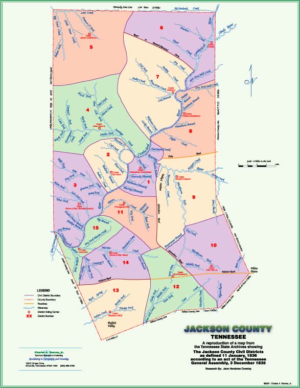
Thanks to the Tennessee State Library and Archives for providing us with a copy of the original map and the descriptions of the districts and for allowing us to use this material. Transcription of the original legal descriptions text was done by Jane Hembree Crowley and can be found below.
Note: A full color reproduction of the above map, which is 17" x 22" in size, is available for $15 plus $4 shipping and handling by Priority Mail. Just send a check to: Charles A. Reeves, Jr.10812 Dineen Drive; Knoxville, TN 37922-1809. Click here to view a low resolution image of the map.
This is to certify that James Young, Richard F. Cooke, David Cox, David Griffith, and Bailey Butler commissioners appointed by a resolution of the General Assembly adopted the 11th December 1835 to lay off the county of Jackson into Districts of Government size within which Justices of the Peace and constables shall be elected, having met in the town of Gainesboro on the 11th day January 1836 in order to proceed upon the duties assigned to them by an act of the General Assembly passed December 3, 1835 when and where said commissioners before Mr. William R. Kenner a Justice of the Peace for said county of Jackson did take the oath prescribed by said act of assembly faithfully and impartially to perform the duties therein directed. (Signed) William R. Kenner
This is to certify that we James Young, Richard F. Cooke, David Cox, David Griffith and Bailey Butler, having been appointed by the General Assembly of the State of Tennessee as commissioners to divide said county into Districts of Government size within which justices of the peace and constables shall be elected after having taken the oath prescribed by law have executed the same in manner and form as directed by an act of the said General Assembly passed December the 3rd 1835 and we do hereby report that the plat hereunto attached is a fair ideal representation of the county and each district therein to the best of our capacity, knowledge and belief which we have laid off so that the butts and boundaries and no. of said plan for holding elections in each district is as follows to wit:
The First District beginning on the south bank of Cumberland River opposite the mouth of Bullards Creek running thence south to the top of the ridge between Flynns Creek and the river thence along the extreme top of the ridge between the waters of Flynns Creek on the south and Murrays Branch, Richmonds Branch, Hancocks Branch and Doe Creek on the north to the head of Morrisons Creek thence along the extreme top the ridge between the waters of Talleys Hollow on the east and Doe Creek and Aarons Branch on the west to Roaring River at Cummins Mill thence down Roaring River with its meanders to the first bluff on the north side of said river thence up the bluff to the Fisk Road at the head of Hurricane Creek thence crossing said road and along the top of the ridge leaving Hurricane and Pigeon Roost Creek on the west down the extreme top of the ridge between Henry Halls and Mathew Andersons striking Cumberland River just below Robert Andersons thence down the river with it meanders to the mouth of the Buck Branch thence up the Buck Branch and out at the head of the same to the top of the ridge between the Buck Branch and Doe Creek thence along the extreme top of said ridge to the head of the Rocky Branch thence down the Rocky Branch to the river thence down the river with its meanders to the beginning and the elections to be held at the court house in Gainesboro.
The Second District shall be bounded as follows to wit: beginning on the south bank of Cumberland River at the mouth of the Buck Branch which is a corner of the First Dstrict turning thence up the Buck Branch with it meanders and out at the head thereof to the top of the ridge between said branch and Doe Creek thence along the extreme top of the ridge between the Horse Shoe Bend and Doe Creek to the head of the Rocky Branch thence down the Rocky Branch with its meanders to Cumberland River thence crossing the river and down the same on the north side thereof with it several meanders to the bluff between the mouths of Indian and War Trace Creeks which is a corner of the 3rd District thence with the line of the 3rd District along the extreme top of the ridge between said creeks to the dividing ridge between Indian and Jennings Creek another corner of the 3rd District thence with the line of the 4th District along the extreme top of the ridge between the waters of Jennings Creek on the north and Indian, Bullards, Trace, Cub, and Hensleys Creeks on the south, to Cumberland River thence across the river to the beginning within which bounds the election shall be held at Jehu Sees.
The Third District shall be bounded as follows to wit: Beginning on the north bank of Cumberland River at the bluff between the mouths of War Trace and Indian Creeks which is the lower corner of the 2nd District turning thence down the river with its several meanders to a point of a hill or bluff just above the plantation of Col. James Holleman and opposite the upper end of Joseph Williamson's plantation thence up said point to the top of the hill between the branch that runs through the plantation of Col. James Holleman and the branch that George W. Clark now lives on thence along the extreme top of the ridge between the branch that runs through the Ruffin old plantation and the branch that runs by Thomas Burton's and Henry Hollemans to the head of the south fork of the Dry Branch thence along the extreme top of the ridge between the Dry Branch and Morelands Branch to Cumberland River at the mouth of the Dry Branch thence down the river with it meanders to the Smith County line thence north with the county line to the top of the dividing ridge between War Trace and Jennings Creeks which is a corner of the 4th District, thence along the extreme top of the ridge between said creeks to the head of Indian Creek which is a corner of the Second District, thence with the line of the Second District, along the extreme height of the ridge between War Trace and Indian Creeks to the beginning within said bounds the elections shall be held at the house of Mrs. Elizabeth Kearby.
The Fourth District beginning at the corner of the 3rd District in the county line where it crosses the dividing ridge between War Trace and Jennings Creek thence north with the county line to the extreme top of the ridge dividing the waters of Jennings Creek and Big Trace Creek of Barren thence along the extreme top of said ridge leaving the waters of Barren on the north and the waters of Jennings Creek on the south to the head of Brimstone Creek thence along the top of the dividing ridge between Brimstone and the Piney Fork of Jennings Creek to the head of Websters Creek thence along the top of the ridge leaving the waters of Websters Creek and Locks Branch on the east and Jennings Creek on the west to Cumberland River just below the mouth of Lock's Branch thence down the river with its meanders to the lower side of the mouth of Jennings Creek to the upper corner of the 2nd District thence with the top of the ridge between Jennings Creek and Hensleys Creek with the lines of the 2nd and 3rd Districts leaving the waters of Hensleys Creek, Cub Creek, Bullards Creek, Indian Creek and War Trace Creeks on the south and Jennings Creek on the north to the beginning and the elections to be held at John Dixon's.
The Fifth District beginning in the Smith County line where it crosses the dividing ridge between Jennings Creek and Big Trace Creek which in the northwest corner of the 4th District turning thence along the extreme top of the ridge between the waters of Barren and Cumberland with the line of the 4th District to the head of the Pine Lick Fork the south east corner of the 4th District, thence with the dividing ridge between Brimstone and Little Trace Creek to intersect the road leading from Cherry's to William Plumlees thence with said road through William Plumlees lane to John Plumlees and Clinton Plumlees and thence to Garret Moores thence northward down the extreme top of the Brushy Ridge to Thompsons old mill on McFarland Creek and on the state line including William Plumlee, John Plumlee, Clinton Plumlee, and Garret More in the 5th District thence west with the state line to the corner of Smith County thence with the county line south to the beginning and the elections to be held at James Crawfords.
The Sixth District beginning in the Kentucky line at the northeast corner of the 5th District turns thence east with the state line to the corner of Overton County on the south bank of Cumberland River then south with the county line to the dividing ridge between the Wet Fork and the Dry Fork of Mill Creek so as to include Thomas Butler in the 6th thence along the extreme top of said ridge between the two forks to the mouth of Mill Creek thence up Cumberland River with its meanders to Bennets Ferry thence crossing Cumberland River and with the main road to Garrett Mores thence northward down the extreme top of the Brushy Ridge with the line of the 5th District to the beginning leaving Garrett More in the 5th District and the election to be held at Celina.
The Seventh District beginning on the north bank of Cumberland River at Bennetts Ferry which is a corner of the Sixth District turns thence down the river with is meanders to the bluff below the mouth of Lock's Branch which is the upper corner of the 4th District turning thence with the northeastern line of the 4th District leaving the waters of Lock's Branch, Websters Creek and Brimstone Creek on the east and Jennings Creek on the west to the line of the 5th District at the head of the Pine Lick Fork of Jennings Creek and to the southeast corner of the fourth District thence with the south boundary line of the 5th District with the dividing ridge between Brimstone and Little Trace Creek to intersect the road between Cherry's and William Plumlees thence with said road through William Plumlees land to John Plumlees, Clinton Plumlees and thence to Garrett Mores thence with the main road to Bennetts Ferry at the beginning and the elections to be held at Baileys at the mouth of Brimstone.
The Eighth District beginning on the south bank of Cumberland River in the fork at the mouth of Mill Creek the lower corner of the 6th District turns thence with the line of the 6th District with the top of the ridge between the wet and dry fork of Mill Creek to the Overton County line thence south with the county line to the Fisk Road between the waters of Roaring River and the waters of Sugar Creek thence with said road to the head of Hurricane Creek thence down a point of the ridge with the line of the First District leaving Hurricane Creek and Pigeon Roost on the west to the river above Henry Halls thence up the river to the beginning and the election to be held near the mouth of Scantlands Branch at William Hamiltons.
The Ninth District beginning in the Overton County line where it crosses the Fisk Road turns thence south with the county line to a point near Peter Smiths and where the nearest road leading from said Smiths to Joseph Terrys intersects the county line thence with said road westwardly to said Smiths and up the Plumb Hollow to Lion Johnson thence with the road leading to Shirley Andersons and Garland Andersons leaving said Smith houses, Lion Johnson, T. Shirley Anderson and Garland Andersons in the 12th District thence up Blackburns Fork with it's meanders to David Richies thence up Bowermans Branch to the Gainesboro Road at Elijah Prices thence with the Gainesboro Road to the head of Doe Creek near James Young a corner of the First District thence with the line of the First District along the extreme top of the ridge leaving the waters of Doe Creek and Aarons Branch on the west and Morrisons Creek and Tallys Hollow on the east to Roaring River at Cummins Mill thence down Roaring River with the line of the 1st District to the first bluff thence up the point of the hill with the line of the 1st District leaving Long Branch on the west to the Fisk Road thence with said road to the beginning and the election to be held at Nimrod Johnson.
The Tenth District beginning at the southeast corner of the 9th District where the nearest road leading from Peter Smiths to Joseph Terrys intersects the Overton County line then southwardly with the county line to the corner of White County near the White Plains thence with the White County line south forty five degrees west to the corner near the Pigeon Roost Creek thence west to said creek thence up said creek to the Richard Bradfords Mill thence northwardly up the hollow west of Bradfords house and with the road leading to John Huddlestons Junr. thence to John Barnes leaving said Huddleston and Barnes in the 10th District thence with the dividing ridge between Pigeon Roost Creek and Huchins Creek and with the road leading to Mark Mathews to Cane Creek thence up said creek to the mouth of Peter Anderson's Spring Branch thence up said branch to Peter Andersons leaving said Anderson in the 12th District thence through the low gap of the ridge to the head of Edward Fins Spring Branch and with said branch to the mouth thence down the middle prong of Blackburns Fork to Mongomery Kennards leaving him in the 10th District thence with the road leading to Liberty Meeting House thence with the old Fort Blount Road to the head of Bowermans Branch at Elijah Prices thence down said branch to David Richies Mill thence down said Blackburns Fork to Garland Andersons thence to Shirley Andersons on the ridge thence to Lion Johnson's in the Plumb Hollow thence down said hollow to Peter Smiths thence with said road to the beginning including said Garland Anderson, T. Shirley Anderson and said Smiths to Lion Johnson in the 10th District and the elections to be held at John Terrys.
The Eleventh District shall be bounded as follows to wit: Beginning on the south bank of Cumberland River at the bluff opposite the mouth of Bullard's Creek turns thence down the river with its several meanders to the bluff just above the mouth of the Big Branch opposite to old Williamsburg thence up the bluff to the extreme top of the ridge between the Big Branch and the branch that runs in at Williams Ferry thence along the extreme top of the ridge leaving the waters of the Big Branch and Martins Creek on the west and Flynns Creek on the east to the head of Flynn's Creek thence north with the line of the 12th District to the main road leading to Gainesboro at Woolbright's thence with said road to the head of Doe Creek to the corner of the First District thence with the extreme top of the ridge with the line of the First District leaving the waters of Doe Creek, Hancocks Branch, Richmonds Branch and Murrays Branch on the north and Flynns creek on the south to the beginning within which bounds the elections shall be held at Thompsons Mill.
The Twelfth District beginning at the southeast corner of the 10th District in the White County line at Pigeon Roost Creek near Michael Tailors thence up the Pigeon Roost Creek to Richard Bradfords Mill thence northward with the west boundary line of the 10th District up the first hollow west of said Bradford's house and with the road to John Huddleston thence to John Barnes leaving said Barnes and Huddleston in the 10th District thence with the dividing ridge between Pigeon Roost Creek and Hutchins Creek and with the road leading on said ridge to Mark Mathews thence up Cane Creek to the mouth of Peter Anderson's Spring Branch thence up said branch to said Andersons and thence down Edward Fins Spring Branch thence down the middle fork of Blackburns fork to Montgomery Kennards thence with the road leading to Liberty Meeting House thence to Woolbrights leaving said Kennard in the 10th District and Peter Andersons in the 12th District thence with the extreme top of the ridge dividing the waters of Flynns Creek, Bowermans Branch and Blackburns Fork to Joseph Pippins Junior including said Pippin in the 12th District thence with the extreme top of the ridge dividing the waters of the west fork of Flynns Creek and James Goolsby's fork of Martins Creek to the junction of said Goolsbys Fork and Harpers Fork of Martins Creek thence up said creek to William Carrs on Walton's Road including said Carr and all the inhabitants east of said creek and road and on said fork in the 12th District thence south from said Carr with the extreme top of the ridge to Gravin Madduxes Spring Branch thence down said branch to Benjamin Browns farm thence with the road leading to said Browns house including said Brown in the 12th District then with the road leading south to the Buffalo Valley Road thence with said road to the road passing Sebert (?) Odoms land to Elias Greens including all the inhabitants of Mine Lick above where the county line crosses said creek in the 12th District thence east with the White County line to the beginning and the elections to be at Bird Kinslows.
Beginning at William Carrs on the Walton Road in the west boundary line of the 12th District runs thence south with said line with the extreme top of the ridge leading to Gravin Madduxs Spring Branch thence down said branch to Benjamin Browns farm thence with the road leading to said Browns house leaving said Brown and Carr in the 12th District thence with the road leading from said Browns south to the Buffalo Valley Road thence with said road to the road passing Sebert (?) Odoms place and to Elias Greens leaving all the inhabitants of Mine Lick above where the county line crosses said creek in the 12th District thence westerly with the White County line to the Smith County corner thence with the Smith County line to the Walton Road thence with said road to the beginning within which bounds the election shall be held at Simpsons Mill.
The 14th District beginning at William Carr on the Walton Road which is a corner for the 13th District turns thence down Harpers fork of Martins Creek to the junction with Goolsby's fork thence up the point with the dividing ridge between the said Goolsbys fork and the west fork of Flynns Creek to Shepherds Road on the ridge thence with said road to near the head of the Dry fork of Martins Creek thence along the extreme top of the ridge between the Dry fork and main fork of Martins Creek to the head of the branch which mouths into James (missing paper?) Mill pond between Henry Sadlers and Leonard Huffs thence a direct course to the main fork of Martins' Creek at the upper end of Henry Sadlers plantation thence crossing the creek at the upper end of Rollins Hogans plantation thence a direct course to the main fork of Indian Creek at the upper end of the Widow Holfords plantation thence crossing the creek at the upper end of Garret Sadlers plantation thence west to the top of the ridge between the main fork and Dillard's Fork of Indian Creek thence along the extreme top of the ridge between said forks and Apples fork and Dillards fork to the Walton Road thence with the Walton Road to the beginning within which bounds the election shall be held at the house of Mrs. Shaw at the mouth of Shaws Branch.
The boundary of the 15th District shall be as follows to wit: Beginning on the south bank of Cumberland River just above the mouth of the Big Branch opposite to old Williamsburgh turns thence up the bluff to the top of the ridge between the Big Branch and the branch which runs in at Williams Ferry thence along the extreme top of the ridge between the waters of Flynns Creek on the east and the Big Branch on the west to the head of the Dry Fork of Martins Creek thence along the extreme top of the ridge between the Dry fork and the main fork of Martins Creek to the head of the branch which mouths into Roberts Mill Pond between Henry Sadlers and Leonard Huffs thence a direct line to the Main Martins Creek at the upper end of Henry Sadlers plantation thence crossing the creek and leaving the plantation of Rollins Hogans on the west thence a direct line to the main fork of Indian Creek at the upper end of the Widow Holfords plantation thence crossing the creek and leaving the plantation of Garret Sadler on the north thence west to the top of the ridge between the main fork and the west fork of Indian Creek thence along the extreme top of the ridge between said forks and Apples Fork and Dillards Fork to the Walton Road thence with said road to the Smith County line thence with the Smith County line to Cumberland River thence across the river to the point opposite upper side of the mouth of the Dry Branch thence along the extreme height of the ridge between the Dry Branch and John Morelands Branch to the head of said branches thence along the extreme height of the ridge leaving the waters of the branches on which Thomas's Burton, Henry Holleman and Col. James Holleman live on the south and the branches turning through the old Ruffin plantation and on which George W. Clark lives on the north to the Cumberland River opposite to the upper end of Joseph Williamsons plantation thence crossing the river and up the same with its meanders to the beginning the elections to be held in said bounds at Granville.
Given under our hands in the Town of Gainesboro the 22nd day of January 1836.
James Young
Richard F. Cook
Balie Butler
David Griffith
David Cox
Note
on Copyright
The
contents of these pages are property of the TNGenNet Inc. and/or
private contributors. Submissions remain the property of the
submitter unless specifically donated to the TNGenWeb Project. Any
reproductions and/or use of this material for profit is expressly
prohibited without the written consent of the contributors and/or the
State Coordinator of the TNGenWeb (TNGenNet Inc.).
Jane
Hembree Crowley
Charles
Reeves, Jr.,
Jackson County Coordinators
This page last updated: .