An Exercise in Research
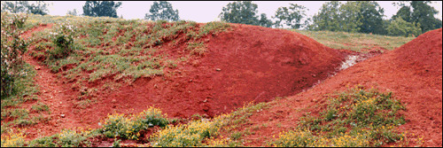
There was tract of land in Warren County which was known as Red Bank(s)
or Browntown. This tract was located in the Second Surveyors’ District on both sides of
the Barren Fork River. It was purchased by William West 1854 and is mentioned in an 1868
law suit.
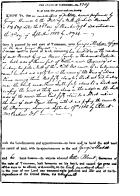
Wm R. Akers Guardian and Admis of Wm West, dec’d
vs.
Wm West and the heirs and creditors of Wm West
... And it is therefore ordered by the Court that the title to the ___ home
farm of Wm West known as Red Bank or Browntown supposed to contain 200 acres be forever
divested out of the heirs and creditors of Wm West and vested in James P. Thompson
Admis. in trust for the benefit of the estate of Lemuel Elam ...
(Warren County Chancery Court Minutes Book 4 pp. 108-112,
TSLA Warren County Microfilm Roll 27.)
Questions to be Answered:
1. What is the exact location of Red Banks or Browntown tract?
2. How do we prove the location of Red Banks or Browntown?
3. Why was Browntown so called and why do we care?
Answer 1., the Location:
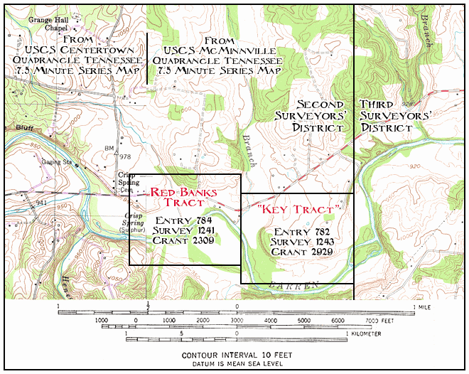
|

Also see: Map Showing the Red
Banks & and “Key” Tracts
Answer 2., Proof of Location
When Robert Brown purchased 200 acres from George Michie in 1812,
the deed identified the tract of land as “red banks.”
The deed also gave the calls (description) of the tract. Those same
calls appear in original 1808 entry and survey, the 1810 grant and the
1854 purchase of the tract by William West. We know that the tract is in
the Second Surveyors’ District on the Barren Fork River. However, the
calls do not tell us where on the river the tract was located.
Fortunately, the documents do state that the tract was joined by entry No.
782 in the name of the heirs of Moses Davis. Entry No. 782 and subsequent
documents place this second, or as we call it, “key” tract on
the eastern edge of the Second Surveyors’ District.
The Red Banks Tract in the Second Surveyors’
District
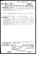
An Entry for George Michie, No. 784, 1808.
A Survey for George Michie, No. 1241 1808.
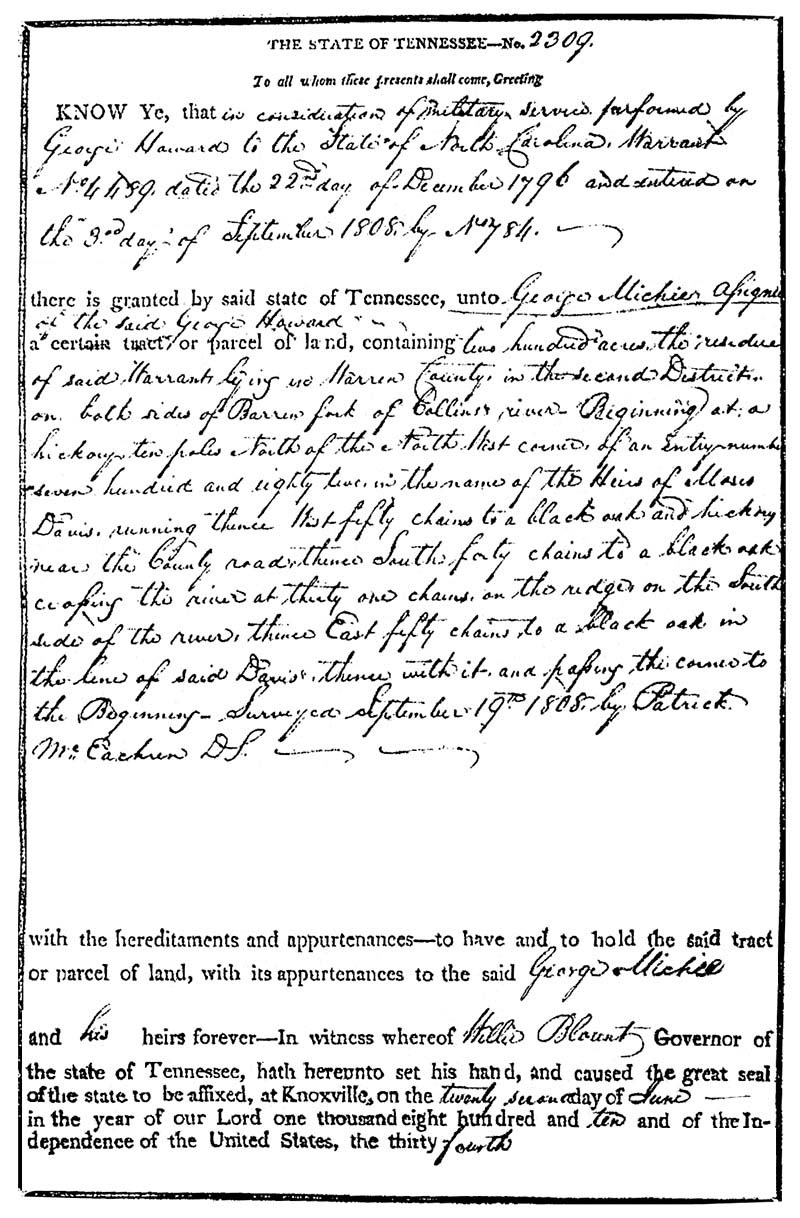
Grant No. 2309 to George Michie, 1810.
“... There is granted by the said state of
Tennessee, unto to George Mitchie assignee of the said George Howard a cetrain tract or
parcel of land containing two hundred acres the residue of said Warrant lying in Warren
County in the second District on both sides of Barren Fork of Collins river Beginning on
a hickory ten poles North of the North West corner of entry numbered seven hundred and eight
two in the name of the heirs of Moses Davis running thence West fifty chains to a black oak
and hickory near the County road thence south forty chains to a black oak crossing the river
at thirty one chains on the ridge on the South side of the river thence East fifty chains to a
black oak in the line of said Davis thence with it and passing the corner to the beginning
Surveyed September 19th 1808 by Patrick McEachern DS ...”
Larger image of Grant, 240k, (Scan
courtesy Gilbert West). Image made from a scan of a photocopy from a TSLA microfilm of the original recording.
George Michie to Robert Brown, a Deed, 1812.
Disposition of the Red Banks Tract.
Josiah F. Morford (clerk and master) to William West, a Deed, 1854.
The “Key” Adjoining Tract in the Second Surveyors’ District
An Entry for the heirs of Moses Davis, No. 782, 1808.
A Survey for the heirs of Moses Davis, No. 1243, 1808.
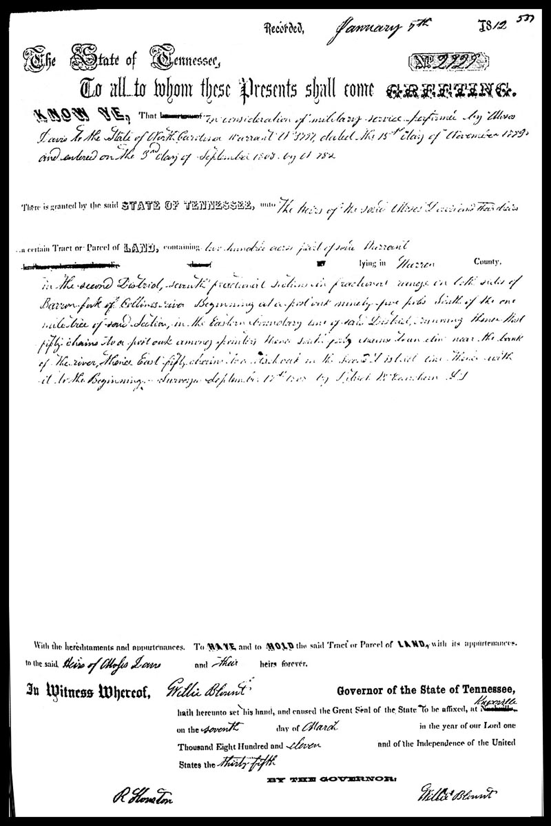
Grant No. 2929 to the heirs of Moses Davis, 1811.
“... There is granted by the said
STATE OF TENNESSEE, unto to the
said Moses Davis and their heirs a cetrain Tract of LAND, containing two hundred acres
part of a Warrant -------- lying in Warren County in the Second District, seventh
fractional section in fractional range on both sides of Barren Fork of Collins river
Beginning at a post oak ninety five poles south of the one mile tree of said Section,
in the Eastern boundary line of said District running thence West fifty chains to a post
oak among pointers thence South forty chains to an elm near the bank of the river thence
east fifty chains to a black Oak in the Second District line thence with it to the
Beginning Surveyed September 19th 1808, by Patrick MacEachern DS ...”
Larger image of Grant, 158k, (Scan
courtesy Gilbert West). Image
made from a scan of a photocopy from a TSLA microfilm of the original recording. On the larger image, you will note that the printed Nashville is
struck out and Knoxville is handwritten. That is because the recorded grant is a copy in
a pre-printed book. Knoxville was the first capital of the State of Tennessee 1796-1812 and at
the time of this 1811 grant. From 1812 to 1815 Nashville was again the seat of government,
and from 1819 to 1825, Murfreesboro served as the state capital. In 1826 the captial was again
transferred to Nashville, where it still remains today.
George Michie to Thomas Brown, a Deed, 1812.
Answer 3., Browntown
(THIS SECTION UNDER CONSTRUCTION)
A third “Brown” tract just to the east of 2nd/3rd
Districts line demonstrates how the Brown family controlled many acres along the
Barren Fork River and on Old Shelbyville Road east of Crisp.
About the Wm Brown survey and Thomas Vaughan grant: we could
not find the Wm Brown entry, this is the first step of getting a grant. Unlike the
Michie and the Davis heirs grants, Wm Brown had a survey based on “his prefference
right” or occupant claim. The other two were based on North Carolina
Military Warrants. We also could not find a grant to Wm Brown. Occupant
claims required payment to the State of Tennessee and since the tract
in the 1808 survey was not granted to Wm Brown, we can assume that he did not
pay the State of Tennessee.
It appears that in 1811 Thomas Vaughan entered on the same
tract and also submitted Wm Brown’s 1808 survey to the Tennessee Land Office.
It was granted to Thomas Vaughan in 1814. There is the possibility that Wm Brown
had an arrangement with Thomas Vaughan to later purchase all or part of the tract, or perhaps he
rented from Thomas Vaughan.
In any case, Thomas Vaughan used a Certificate issued by the Register of
Western Tennessee to qualify for the grant.
A second tract of three acres granted to Thomas Vaughan actually
joins the west side of the Brown three hundred acre survey and this tract of three
acres is “... near to the eastern boundary of the 2nd District ...” Hence,
we are able to plat the location of the two 3rd District tracts and place them in
relationship to the two 2nd District tract.
Two Third Surveyors’ District Tracts
A 300 Acre Tract:
An Entry for Wm Brown. (Not Found)
A Survey for Wm Brown, Book 35, page 5, 1808.
Grant No. ___ to William Brown. (Not Found)
An Entry for Thomas Vaughan, Book B, p. 260, 1811.
Grant No.5932 (Book H, p.328, File Number 5932) to Thomas Vaughn, 1814.
“ ... by virtue of part of Certificate Number 53 dated Feb. 7, 1810, issued by
the Registrar of Western Tennessee to William P. Anderson and entered on 7th day
of Aug 1811 ... under an act of 1807. Granted by the State of Tennessee unto
Thomas Vaughan, assignee of William P. Anderson for 300 acres in Warren County
in the Third District on both sides of the Barren Fork of Collins River in boundary
line Walter M. Daniel and William Brown.” [Signed] Willie Blount, Governor of Tenn.,
Aug. 11, 1814, W. G. Blount, Secretary.
Abstract from Moses Park, 1738-1828 -- Vaughan and Wilcher, by Clara Lorene
(Cammack) Park and Wilbur Goolsby Park, Sr. Gateway Press, Inc., 1991.
A 3 Acre Tract:
An Entry No.2924 for Thomas Vaughan, Book D, p. 147, 1814.
A Survey for Thomas Vaughan, Book 34, page 357, 1814.
Grant No.6737 to Thomas Vaughan, 1815.
|
|