|
Southwest Territory
1790-1796
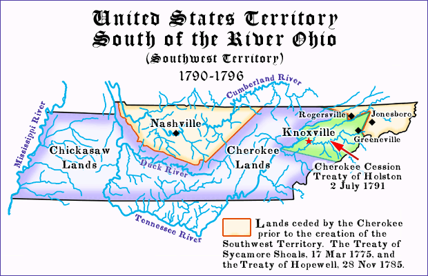
Southwest Territory Boundaries
“ON the 25th of May, 1790, Congress passed a law for the
government of the country south-west of the river Ohio. They
declared that for the purposes of temporary government it
should be one district, the inhabitants of which should
enjoy all the privileges, benefits, and advantages set
forth in the ordinance of the late Congress, made in July,
1787, for the government of the territory
of the United States north-west of the river Ohio, except so far as
otherwise provided for in the conditions expressed in the act of Congress
of the present session for accepting the cession made by North
Carolina. One of these conditions, as will be seen by recourse
to the act, was that no regulations made or to be made by Congress
shall tend to emancipate slaves.
“To know precisely what this government was which was now
extended over the whole of the ceded territory since called the
State of Tennessee, recourse must be had to the ordinance itself,
and to an act of Congress, amendatory of the ordinance, passed the
7th of August, 1789, which ordinance and act of Congress with the
cession together with the cession
act of North Carolina ...”
|‡|

When North Carolina ceded her
western lands the United States, that vast tract became the only land located
“Southwest of the River Ohio” that could become a federal
territory. It was the North Carolina cession that left the tract surrounded
by non-federal entities. To the east was North Carolina proper. To the north was Virginia;
Kentucky was not created from Virginia lands until 1792. To west there
was the Mississippi River|‡| and beyond
was Spanish land. Lastly, to the south was Georgia, or at least
Georgia’s western lands. The boundaries of the Territory
of the United States, south of the river Ohio seem to be omitted
from the 26 May 1790 Act which created that Territory. In his 1823 book,
Judge John Haywood points out
that “recourse must be had ... cession act of North Carolina ...”
Looking further back, we see that Thomas Jefferson defines the boundaries of the
territory in his 1791 report to President George Washington.
Act for Government
of the Southwest Territory
Section 1. Be it enacted by the Senate and House of Representatives
of the United States of America in Congress assembled,
That the territory of the United States, south of the
river Ohio, for the purposes of temporary government,
shall be one district; the inhabitants of which shall
enjoy all the privileges, benefits and advantages, set
forth in the Ordinance of the late Congress, for the
government of the territory of the United States,
north-west of the river Ohio; and the government of the
said territory, South of the Ohio, shall be similar to
that which is now exercised in the territory north-west
of the Ohio; except so far as is otherwise provided in
the conditions expressed in an Act of Congress of the
present session, entitled, “An Act to accept a cession
of the claims of the State of North Carolina, to a certain
district of western territory.”
Sec. 2. And be it further enacted, That the salaries of the Officers,
which the President of the United States shall nominate, and
with the advice and consent of the Senate, appoint by virtue
of this Act, shall be the same as those, by law established,
of similar Officers in the government north-west of the river
Ohio. And the powers, duties, and emoluments of a Superintendent
of Indian Affairs for the Southern department, shall be united
with those of the Governor.
Frederick Augustus Muhlenberg
Speaker of the House of Representatives.
John Adams,
Vice President of the United States, and
President of the Senate.
Approved May twenty sixth 1790
G. Washington
President of the United States
Thomas Jefferson to George
Washington
Philadelphia, November 8, l791.
Sir:
I have now the honor to enclose you a report on the lands of the
United States within the Northwestern and Southwestern Territories,
unclaimed either by Indians or by citizens of these States.
In order to make the estimate of their quantity and situation, as
desired by the Legislature, it appeared necessary, first, to delineate
the Indian boundaries which circumscribe those territories, and then to
present a statement of all claims of citizens within the same; from whence
results the residuary unclaimed mass, whereon any land law the Legislature
may think proper to pass nay operate immediately, and without obstruction.
I have not presumed to decide on the merits of the several claims,
nor, consequently, to investigate them minutely; this will only be proper,
when such of them as may be thought doubtful if there should be any such,
shall be taken up for final decision.
I have the honor to be, with sentiments of the most perfect respect and attachment,
Sir, your most obedient and most humble servant,
Th. Jefferson,
The PRESIDENT of the U. States.
The Secretary of State, to whom was referred, by the President
of the United States, the resolution of Congress, requesting the President “to
cause an estimate to be laid before Congress, at their next session, of the quantity
and situation of the lands not claimed by the Indians, nor anted to, nor claimed by,
any citizens of the United States, within the territory ceded to the United States by
the State of North Carolina, and within the territory of the United States, northwest
of the River Ohio,” makes thereon the following report:
The territory ceded by the State of North Carolina to the United States, by
deed bearing date the 25th day of February, 1790, is bounded as follows, to
wit: Beginning in the boundary between Virginia and North Carolina, that is to
say, in the parallel of latitude 36½ degrees north from the equator on the
extreme height of the Stone mountain, where the said boundary or parallel
intersects it, and running thence along the said extreme height, to the
place where Watauga river breaks through it; thence a direct course to
the top of the Yellow mountain where Bright’s road crosses the same;
thence along the ridge of the said mountain between the waters of Doe
river and the waters of Rock creek, to the place where the road crosses
the Iron mountain; from thence along the extreme height of said mountain
to where Nolichucky river runs through the same; thence to the top of the
Bald mountain; thence along the extreme height of the said mountain to the
Painted rock on French Broad river; thence along the highest ridge of the
said mountain to the place where it is called the Great Iron or Smoky
mountain; thence along the extreme height of the said mountain to the
place where it is called Unaka mountain, between the Indian towns of
Cowee and Old Chota; thence along the main ridge of the said mountain
to the southern boundary of the said State of North Carolina, that is to
say, to the parallel of latitude 35 degrees north from the equator; thence,
westwardly, along the said boundary or parallel to the middle it the River
Mississippi; thence up the middle of the said river to where it is
intersected the first mentioned parallel of 36½ degrees; thence
along the said parallel to the beginning: which tract of country is a
degree and a half of latitude from north to south, and about three
hundred and sixty miles, in general, from east to west, as nearly as may
be estimated from such maps as exist of that country …
In addition to the calls of the ceded tract, the North Carolina cession act
also had important certain provisions:
“ ... the said Congress shall at the same time assume the government
of the said ceded territory, which they shall execute in a manner similar to
that which they support in the territory west of the Ohio; shall protect the
inhabitants against enemies, and shall never bar or deprive them of any
privileges which the people in the territory west of the Ohio enjoy:
Provided always, That no regulations made or to be made by Congress, shall
tend to emancipate slaves ... ”
1. Haywood, John, Judge; The Civil and Political History of the
State of Tennessee from its Earliest Settlement up to the Year
1796 Including the Boundaries of the State, 1823.
|Return|
2. The Treaty of Paris, 1763, established the Mississipi River as the western
limits of British colonial America. This in effect terminated claims of some
British colonies of their rights under original charters to land running
westward to the “south seas.”
The Treaty of Paris, Article VII (partial)
VII. In order to reestablish peace on solid and durable foundations,
and to remove for ever all subject of dispute with regard to the
limits of the British and French territories on the continent of
America; it is agreed, that, for the future, the confines between the
dominions of his Britannick Majesty and those of his Most Christian Majesty,
in that part of the world, shall be fixed irrevocably by a line drawn along
the middle of the River Mississippi, from its source to the river Iberville,
and from thence, by a line drawn along the middle of this river, and the
lakes Maurepas and Pontchartrain to the sea; and for this purpose,
the Most Christian King cedes in full right, and guaranties to his Britannick
Majesty the river and port of the Mobile, and every thing which he possesses,
or ought to possess, on the left side of the river Mississippi, except the town
of New Orleans and the island in which it is situated, which shall remain to
France, provided that the navigation of the river Mississippi shall be equally free,
as well to the subjects of Great Britain as to those of France, in its whole
breadth and length, from its source to the sea, and expressly that part which is
between the said island of New Orleans and the right bank of that river,
as well as the passage both in and out of its mouth: ...
|Return|
Some Southwest Territory Research Sources:
National Archives Microfilm, M-471,
State Department Territorial Papers: Territory Southwest of the River
Ohio, 1790-1795. Roll 1. On the single roll of this microfilm series is
reproduced the bound volume of papers of the Department of State relating
to the Territory Southwest of the River Ohio. This volume is from the
series “Papers and Records of the Territories” and is described by Van
Tyne and Leland in Guide to the Archives at Washington, p. 45.
“The territory was created by the Organic Act of 1790 and the cession of
the claims of the North Carolina to a portion of its western land. The
territory was terminated with the creation of Tennessee in 1796. Two
documents at the beginning concern pre-Revolutionary land grants and
loyalty to the British crown. The remainder relate to territorial
business. These include appointments, commissions, organization of
counties, licensing of Indian traders, and a census. Negotiations with
Creek and Cherokee Indians are also described.”
Carter, Clarence Edwin, comp. & ed.
The Territorial Papers of the United States. Volume IV: The Territory
South of the River Ohio, 1790-1796
Washington: Government Printing Office,
|
|