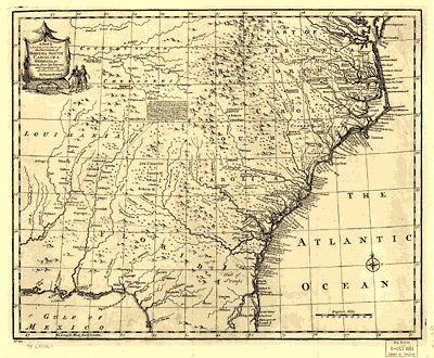
Two Colonial Period Maps of the American Southeast
by  Emanuel Bowen

Please Scroll Down

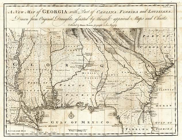
A New Map of Georgia, with Part of Carolina, Florida and Louisiana.
Drawn from Original Draughts assisted by the most approved Maps and Charts
Collected by
Eman: Bowen, Geographer to His Majesty.

Georgia Map, 1748


Map Maker: Emanuel Bowen
Place / Date: London / 1748
Size: 18.5 x 14 inches

A rare 1748 map of Georgia, Florida, the Carolinas and Louisiana, from John Harris’ Navigantium atque Itinerantium Bibliotheca, or Complete Collection of Voyages and Travels, first published in London in 1705. The map of Georgia first appeared in the 1744-48 and 1764 editions, when a new Chapter was added, giving a history of Georgia. The map covers the region from Charleston to the Mississippi River.
This is one of the best large format maps of the region during the period, showing coastal settlements in South Carolina, the Indian Tribes friendly or hostile to the English, and the chief trading paths of the period. Indian territories are shown by fine dotted lines. The Georgia roads and settlements are particularly complete. Excellent detail along the Flint River.

(Note: The image on this page was borrowed from the website of Barry Lawrence Ruderman, Old Historic  Maps & Prints, www.raremaps.com and used with his kind permission.)

Map Image & Descriptive Text,
© 2002, Barry Lawrence Ruderman


Compass Rose

A New &
Acurate Map of the Provinces of
NORTH & SOUTH CAROLINA, GEORGIA &c.
Drawn from late Surveys
and regulated by Astronl. Observatns.
By Eman. Bowen.


Click Here to see a very large and readable version of the 1752 Map. (776k)


Map Maker: Emanuel Bowen
Place / Date: London / 1752

This map by Emanuel Bowen (b. ca1720, d. 1767) is from A Complete Atlas or Distinct View of the Known World. 1752. It covers an area that includes part of Florida, part of Louisiana, (spelled Louisiania on the map), Georgia, North & South Carolina, part of Virginia, and the “Country of the Cherokees.”
While Bowen’s 1752 map extends further northward than his 1748 map, it does not reach nearly as far westward. The 1748 map reaches beyond the Mississippi and shows a greater Georgia running “far out west.” At one time, Georgia claimed those western lands. In 1802 Georgia sold its title to United States government. On the 1752 map, Georgia is shown as a much smaller tract.
The 1748 map (but not the 1752 map) places the Yamasee Indians, a much abused people who have since disappeared.
Some of the “Country of the Cherokees.” shown on the 1752 map became the state of Tennessee in 1796. We see “English Fort and Factory” just above the two Indian figures. That fort would be on the today’s Tennessee River, below the mouth of Elk River. That was England’s frontier fort, put there to compete with the Spanish and especially the French.


Text From the 1752 Map
Detail Image (62k)

The  Cherokee Indians is a Numerous & Warlike Nation; and as they are in Amity & Alliance wth the Subjects of ye King of Great Britian, they serve as a powerful Barrier to  Carolina & Georgia in ye present War against France & Spain. The Emperor of ye  Cherokees & the King of ye  Catawaas renew’d their League of Friendship wth Govr Glenn at Charles Town in Sth Carolina in May 1745.


Map Image Source:
American Memory, Library of Congress
CALL NUMBER G3900 1752 .B6 Vault
CONTROL NUMBER 74693267


Compass Rose

Page © 2002, TNGenNet Inc.

Return to
Maps Home Page
or
Click “Back” to return to your last page visited.