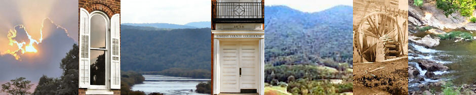
County Boundaries – Private Legislative Acts
Published for the Quarterly County Court by the County Technical Assistance Service, University of Tennessee Institute for Public Service, Nashville, TN, 1976. Transcribed by Billie McNamara in 1996. A current, digital version of this information is available on-line.
Contents of Private Acts:
Creation of Counties
Acts of 1786 — Chapter No. 34
An Act Dividing the County of Sullivan
Section 1. Be it enacted by the General Assembly of the State of North Carolina, and it is hereby enacted by the authority of the same, That from and after the passing of this Act, the said County of Sullivan be divided in the following manner, beginning where the boundary line between the Commonwealth of Virginia and the State of North Carolina crosses the North Fork of Holston River, thence down said fork to its junction with the main Holston River, thence across said river due south to the top of Bayes Mountain, thence along the top of the said mountain and the top of the dividing ridge between the waters of Holston River and French Broad River to its junction with Holston River, thence down said river Holston to its junction with the Tennessee River, thence down the same to the Suck where said river runs through Cumberland Mountain, thence along the top of said mountain to the aforesaid boundary line, and thence along said line to the beginning; and that all that part of Sullivan County on the east side of the North Fork of Holston River shall continue and remain a distinct county by the name of Sullivan, and all that other part which lies west of said North Fork of Holston shall thenceforth be erected into a new and distinct county by the name of Hawkins.
1792. — Ordinance.
An Ordinance for circumscribing the counties of Greene and Hawkins, and laying out two new counties [Jefferson and Knox]. — Done, June 11.
Section 1. Be it ordained, That from and after the fifteenth day of the present month of June, the counties of Greene and Hawkins shall be circumscribed by a line beginning on Nolichucky River at the place where the ridge which divides the waters of Bent and Lick Creek strikes it; thence with that ridge to Bull’s Gap of Bay’s Mountain; thence a direct line to the place where the road that leads from Dodson’s Ford to Perkin’s iron works crosses the watry [sic] fork of Bent Creek; thence down that road to the head of Panther Creek, down the meanders of that creek to the river Holston; thence a northwest course to the river Clinch; again, from Nolichucky River where the ridge that divides the waters of Bent and Lick Creek strikes it, a direct course to Peter Fine’s ferry on French Broad; then south to the ridge that divides the waters of French Broad and Big Pigeon, and with said ridge to the eastern boundary of the territory.
Section 2. That two new counties be laid out and established below the aforesaid line, that is, to the southward and westward of it, to be distinguished from and after the said fifteenth day of June instant by the name of Jefferson County, and Knox County. [Remainder contains boundaries of Jefferson County.]
Acts of 1796 Chapter No. 28
An Act erecting part of the county of Hawkins, and part of the county of Knox into a separate and distinct county [Grainger]. — Passed, April 22.
Section 1. Be it enacted by the General Assembly of the State of Tennessee, That the said counties of Hawkins and Knox be divided by the following lines: Beginning on the main road leading from Bull’s Gap to Haines’s iron works, on Mossy Creek, at the house of Felps Read, leaving said house in the new county, running a direct course to the Kentucky road, on the north side of Holston River, a quarter of a mile above the house of Thomas Henderson; thence north fifty degrees west to the line that divides this State from the State of Virginia; thence west with said line to a point, northwest of the end of Clinch Mountain; thence a direct course to the end of Clinch Mountain; thence with the ridge that divides the waters of Richland and Flat Creeks to Holston River, at the upper end of the first bluff above Boyles’s old place; thence up the meanders of said river to the mouth of Panther Creek; thence up said creek to the head spring thereof, near the house of John Evans; thence along the main wagon road to the beginning and all that part of the aforesaid counties of Hawkins and Knox, contained within the lines before described, be erected into a separate and distinct county by the name of Grainger.
Acts of 1801 Chapter No. 46
An Act erecting part of the counties of Hawkins and Grainger into a separate and distinct county [Claiborne]. — Passed, Oct. 29.
Section 1. Be it enacted, etc., That Hawkins and Grainger counties be divided by the following lines, to wit: Beginning on the north bank of Clinch River where the Hawkins and Grainger line crosses the same, thence down the north bank of said river Clinch, to a point opposite where the Knox and Grainger line strikes the said river, thence north, forty five degrees west, to the line which divides this state from the state of Kentucky, thence east with said line to where it intersects with the line which divides this state from the state of Virginia, thence due east with said line to a point from which a direct line to the beginning will leave 625 square miles in the county of Hawkins, and all that part of the aforesaid counties of Hawkins and Grainger contained within the lines before described, shall be a separate and distinct county by the name of Claiborne.
Section 13. That Clinch River and the path leading from the mouth of Greasy Rock Creek to the head of Mulberry Creek, shall be the dividing line between the county of Hawkins and the county of Claiborne, until the true line shall be ascertained.
Section 17. That this act shall be in force from and after the sixth day of December next.
Acts of 1844 Chapter No. 61
An Act to establish the county of Hancock, in honor of John Hancock, one of the patriots of the Revolution. — Passed, Jan. 7.
Section 1. Be it enacted, That a new county be, and the same is hereby established, to be composed of fractions taken from the counties of Hawkins and Claiborne, and to be known and designated by the name of Hancock County, in honor of John Hancock, one of the patriots of the Revolution.
Section 2. That the county of Hancock shall be bounded as follows, to-wit: Beginning at a white oak on the Virginia line, near John Overton’s; then south eight degrees, west to Powell’s River, thence south nineteen degrees, east crossing Powell’s Mountain, to the Chalybeate Spring on Sycamore; thence down the same to near Daniel Jones’ saw mill; thence south to Clinch River; thence up the meanders of the same to the Hawkins and Grainger line; thence with the same crossing Clinch Mountain to the Poor Valley; thence up the valley until a due north course will cross said mountain at the west bluff at the Big War Gap on Copper Ridge; thence eastwardly along said ridge until passing the Little War Gap; thence south forty-five degrees east with the same to the Virginia line; thence west with the said line to the beginning.
Section 16. [Provides that if the boundary lines of Hancock County as designated in section two of this act shall approach within the twelve mile limit of other counties said lines shall be re-run and re-marked so as not to violate the constitutional right of said other counties.]
Section 17. [Provides that Poor Valley in the county of Hawkins shall not be within the boundary of the county of Hancock.]
Acts of 1870 Chapter No. 6
An Act to establish the county of Hamblen, in honor of the late Hezekiah Hamblen, Esq., of Hawkins County. — Passed, May 31; approved, June 8.
Section 1. Be it enacted, etc., That in conformity to the fourth section of the tenth article of the Constitution of the State of Tennessee, a new county be, and the same is hereby established, to be composed of fractions to be taken from the counties of Jefferson and Grainger, to be known and designated as Hamblen County.
Section 2. That the boundaries of the county of Hamblen shall be as follows, viz: Beginning at four cedars on the northern bank of Nolachucky River, at the point where the boundary line between Jefferson and Greene Counties to Rader’s Spring, at or near Bull’s Gap; thence with the line between Hawkins and Jefferson Counties to Mount Sterling, at or near the house of Wm. Pangle; thence with the line between Hawkins and Jefferson Counties to Cheek’s cross roads; thence with the line between Hawkins and Grainger Counties to the center of Holston River; thence down the Holston River, with the meanders thereof, to the mouth of Hull’s branch; [Remainder does not mention Hawkins County.]
Section 17. That the fraction of Hawkins County south of Holston River, adjoining the present line of Grainger County on the west and the line of Jefferson County on the south-east, by a line to commence at or near Mount Sterling, on the Jefferson County line, eleven miles distant from Rogersville, running thence a direct line to the Holston River, so as to keep eleven miles from Rogersville; thence down the Holston River, with its meanders, to the point where the present line between Hawkins and Grainger Counties strikes said river, may be included and constitute part of the county of Hamblen, established by this act, … but if two-thirds of all the qualified voters in said fraction Hawkins County shall fail to vote for the establishment of the new county, their refusal to do so shall in no manner affect the establishment of the county of Hamblen, as provided in this act, out of fractions of the counties of Jefferson and Grainger.
Adjustments to County Lines
The private act has often been used as a means for transferring parcels of land from one county to another, usually because the boundary lines would bisect an individual landowner’s property, placing him under the jurisdiction of two counties. This type of boundary change was usually very general in its description of the land transferred, without any metes and bounds description. The following private acts authorized such boundary changes for Hawkins County.
Acts of 1792, Chapter 16, appointed Joseph McMinn, of Hawkins County, and George Rutledge, of Sullivan County, Commissioners to run and mark the line between the two counties from the mouth of the North Fork of the Holston River to the top of Bayes Mountain, for which they shall each be paid $2.00 per day and the markers shall be paid $1.00 per day. This act also appointed John Payne and Charles McClung to run the line between Hawkins and Knox Counties from the mouth of Panther Creek to Clinch River at $2.00 per day compensation which would be paid equally by the two counties.
Acts of 1796, Chapter 28, separated parts of Hawkins County and Knox County into a separate county to be called Grainger County. The affected area in Hawkins County was described by metes and bounds, and most of the act was devoted to the establishment of the new county. This act was repealed by the Act of 1797, Chapter 13, Section 6.
Acts of 1797, Chapter 13, Section 6, stated that that part of an act erecting part of the county of Hawkins and part of the County of Knox into a separate and distinct county, passed at Knoxville in 1796, is hereby entirely repealed.
Acts of 1801, Chapter 55, appointed Joseph Cobb a Commissioner to run the line between Grainger and Hawkins Counties from the northwest corner of Joel Dyer’s and Thomas Henderson’s land to the Clinch River which is agreeable to an act of the General Assembly in that respect. Cobb was allowed to employ a marker at $1.00 a day and be paid $2.00 per day himself.
Acts of 1801, Chapter 56, stated that Daniel Carter of Greene County and William Payne, of Hawkins County, were appointed Commissioners to mark and designate the line between those two counties, both to be paid $2.00 per day compensation.
Acts of 1806, Chapter 53, passed Sept. 11; Section 1: At so much of the ordinance aforesaid, as respects the line beginning on Nolichucky river, at the place where the ridge which divides the waters of Bent and Lick creek strikes the same; thence with that ridge to Bull’s Gap of Bays Mountain, at the house of William Cross, leaving the same in the county of Greene; thence eastwardly along the main height of Bays Mountain, to the Chimney Top mountain, be, and the same is hereby declared to be the line between the counties of Greene and Hawkins, so far as leads from William Cross’s in Bull’s Gap, to the top of Chimney Top Mountain.
Section 2. That all laws and parts of laws coming within the purview of this act, whether published by the authority of this state, or the state of North Carolina, are declared null and void.
Acts of 1809, Chapter 29, passed Nov. 2: That the lines hereafter described, shall be the dividing lines between the counties of Hawkins and Grainger, to-wit: Beginning at or near the house of John Moffatt, esquire, where the original line between said counties began, running thence with the road leading from Haynes’s Iron Works to Cheeks Cross Roads to where John Moffatt’s line crosses said road, then with said line to the road leading from Cheek’s Cross Roads to Marshall’s Ferry on Holston River, then with said road to where it crosses the present line between said counties, and all that part lying westwardly of said line, shall be added to and made a part of Grainger county, any law to the contrary notwithstanding: PROVIDED, That nothing herein contained, shall be so construed as to prevent any collector or other officer of Hawkins county from collecting any arrearages of taxes or other demands which may be due.
Acts of 1815, Chapter 13, provided that the newly cut road so far as it extends through the plantation of Thomas Crosby on the road leading from Cheek’s Cross roads to Dotson’s Ford on the Holston River shall be considered and taken as the line between Hawkins and Jefferson Counties, leaving the said Crosby wholly within Hawkins County.
Acts of 1821, Chapter 154, appointed Gabriel McCraw, of Hawkins County, Charles T. Porter, of Jefferson County, and Joseph Shannon, of Grainger County, as Commissioners to run and mark that part of the line between the counties of Hawkins and Jefferson from the marked corner of the watery Fork of Bent Creek where the road leading from Dodson’s Ford, on the Holston River, to Cheeks Cross Roads, crosses the same, to Bull’s Gap. The Commissioners shall report to the Quarterly Court when their work was completed.
Acts of 1824, Chapter 121, stated that the line between Hawkins and Claiborne Counties from the mouth of Greasy Rock Creek to the Virginia line, shall hereafter be as follows: beginning at the mouth of Greasy Rock Creek and thence to run northwardly along a road of the third class to Mulberry Gap in Powel’s Mountain, so as to include a 640 acre tract of land granted by the State of North Carolina to Matthew Willeby so as to leave said tract of land in Hawkins County, and thence along the extreme height of said Powel’s Mountain eastwardly to the Virginia line.
Acts of 1835-36, Chapter 29, formed a new county out of parts of Sullivan, Hawkins, Washington, and Greene Counties to be called Powell County after Sam Powell, a Circuit Judge. A detailed description of the involved area is incorporated into the law. A quantity of territory is taken from the upper area of Hawkins County on the north side of the river, to a point one mile north of Phillip Hale’s, thence running so as to cross the main stage road between the house of William Bradley and the place where William Armstrong formerly lived, in a southerly direction to a point 12 miles from Rogersville, provided that a majority of the citizens living in this area vote to leave the county.
Acts of 1837-38, Chapter 192, provided for a new county, to be called Powell, which would be formed out of parts of Hawkins, Sullivan, Washington, and Greene, but the idea must be approved by a majority of the people in the affected area. Samuel Morelock, Wesley Ball, and John Barnett, of Hawkins County, join others already designated as Commissioners to hold the election.
Acts of 1839-40, Chapter 15, was yet another effort to form Powell County out of Sullivan, Hawkins, Washington, and Greene Counties, the formation still being subject to approval by a majority of the voters in the affected area. All the initial details incidental to the formation of a new county are present herein.
Acts of 1849-50, Chapter 69, changed the lines between Grainger, Hawkins, and Jefferson Counties so as to include the store house of Obadiah Boaz, at Cheek’s Cross Roads in Grainger County; so that the line will run with the Main Stage Road leading from Knoxville to Jonesboro, to Cheek’s Cross Roads and from thence along the Bean Station Turnpike to the residence of Obadiah Boaz. Section 2 transferred the farm belonging to David Harris out of Hawkins County and into Grainger County.
Acts of 1851-52, Chapter 299, changed the lines between Hawkins and Jefferson Counties so as to place in Hawkins County the area beginning on the side of the road leading from Russellville to Knoxville where the Arnot Road intersects said road near Taylor’s Blacksmith Shop at Cheek’s road, thence with said Arnot’s Road to Arnot’s Gap at the Greene County line. All residents of the area are entitled to same privileges as other citizens of Hawkins County.
Acts of 1851-52, Chapter 302, rearranged the boundary lines between Hawkins and Hancock counties beginning where the line of said counties now cross the fords of Turkey Creek below C. W. Manis’s and running a due north course to the top of the river ridge, and with said ridge eastwardly to George Herd’s line, then with Herd’s line eastwardly, crossing the dry branch to two marked sugar trees, thence south, so as to intersect the present line at the branch by John Smith’s and to include Lewis Anderson in Hawkins County.
Acts of 1853-54, Chapter 130, passed 31 January, Section 3: That the dividing line between the counties of Jefferson and Hawkins be changed as follows: Beginning at or near George Lynch’s on the line between said counties of Jefferson and Hawkins; running with said line to the Walnut Gap; from thence a direct line to the north-east boundary line of Pleasant Kirkpatrick’s plantation, and with said line till it strikes the road leading from Russellville to Bull’s Gap; and with said road till it strikes the county line of Greene and Hawkins, below Bull’s Gap.
Section 4. That the persons and property included in the fraction of Jefferson, lying north-east of said line, as described in the first section of this act, shall be entitled to all the rights and privileges of the citizens of Hawkins, and subject to all the duties thereof; and the act passed February 16, 1852, entitled “an act to change the line between the counties of Jefferson and Hawkins,” be, and the same is, hereby repealed.
Acts of 1857-58, Chapter 143, was another effort to form Powell County out of portions of Sullivan, Hawkins, Greene, and Washington which was not to become effective until approved by the people living in the affected areas.
Acts of 1866-67, Chapter 9, moved the mill and tract of land belonging to Hiram Herd out of Hancock County and into Hawkins County.
Acts of 1867-68, Chapter 13, Section 2, transferred the farm belonging to John Caldwell from Grainger County into Hawkins County.
Acts of 1867-68, Chapter 60, moved the farm of William Davis out of Hancock County and into Hawkins County and a tract of land belonging to the heirs of Benegis White out of Hawkins and into Hancock County.
Acts of 1869-70, Chapter 30, again sought to create Powell County out of portions of the same four other counties and under the same conditions, all subject to approval by referendum of the people living in the affected area.
Acts of 1869-70, Chapter 88, Section 9, changed the boundary lines between Hawkins and Hancock Counties so as to include the home and lands of John Jones wholly within Hancock County.
Acts of 1870-71, Chapter 92, passed Jan. 20; Section 1: That the line between the counties of Hamblen and Hawkins shall be, and the same is, hereby changed, so as to run as follows: Beginning on the Holston river where the line between said counties now strikes the river; thence up the river, with the meanders thereof, to a point on said river where the line extended from Mount Sterling north forty-one degrees west, will strike said river; thence with said line south forty-one degrees east, to Mount Sterling, so as to include all that part of Hawkins County lying south and east of Holston River, and south and west of said line running from Mount Sterling north forty-one degrees west, to the river, in said county of Hamblen.
Section 2. That the Tax Collector of Hamblen county shall collect the taxes assessed for the year 1871, in the territory or district taken from Hawkins and attached to Hamblen; and the county revenue collected from the people of said territory or district for the year 1871, shall belong to and constitute a part of the county fund of said Hamblen county.
Acts of 1871, Chapter 19, changed the lines between Hawkins and Hamblen Counties so as to include within Hawkins County the tract of land on which J. W. Keele, H. P. McCullough and Thomas Moore now reside. Section 5 of the same act transferred the property of Clisby Austin, located at Rogersville Junction, and all that part of the public road known as “White Horn Road,” leading southwest of said land, into the new county of Hamblen in accordance with Austin’s express desire.
Acts of 1871, Chapter 91, was an exact duplicate of Chapter 19, Acts of 1871, abstracted above.
Acts of 1872 (E.S.), Chapter 19, Page 42, was a second duplication of Chapter 19, Acts of 1871, abstracted above.
Acts of 1873, Chapter 14, Page 15, moved the residences and lands of Thomas Moneyhun, James Moneyhun, Nicholas Moneyhun, and Andrew Eadens out of Hancock County and into Hawkins County.
Acts of 1873, Chapter 69, Section 3, transferred the home and farm of Daniel Reed out of Hawkins County and into Hamblen County.
Acts of 1877, Chapter 137, moved all the property belonging to A.M. Trullinge out of Hawkins County and into Hamblen County.
Acts of 1877, Chapter 140, passed 23 March; Section 1: That the county line between the counties of Hancock and Hawkins be changed as follows: beginning in the line of said counties on the top of the Middle Ridge; thence eastwardly along on the top of said ridge to the pike road; thence with said road and the line of Wm. J. Davis’ farm to the top of War Ridge; thence along on the top of said ridge eastwardly to John Curry’s east corner on said ridge; and thence northwardly and eastwardly with said Curry’s line to the Hancock and Hawkins line; and all the parts of farms of Wm. J. Davis, Robt. D. Green, Wm. D. Trent, and John Curry, lying on the north and west of this line be included in and constitute a portion of Hancock county, the written assent of the parties by petition having been made to this General Assembly.
Acts of 1877, Chapter 149, detached the farm of Anderson Mullens from Hawkins County and attached the same to Grainger County.
Acts of 1879, Chapter 159, recited that the line between Hawkins and Sullivan counties from the top of Chimney Top Mountain to the mouth of the north fork of the Holston River is uncertain and about to become the basis of a lot of litigation, this act requires that the County Surveyors of Sullivan and Hawkins Counties, along with David Sevier of Sullivan County and J.E. Denney of Hawkins County to re-run and to re-mark the line between those two points. They may employ two chain bearers and within six months make two plats of said line, a copy of each to be filed in the Register’s office of the two counties. The Commissioners shall be paid $2.00 a day for their services and the chain bearers will receive $2.00 a day to be borne equally by the two counties. This act was repealed by Chapter 239, Acts of 1883.
Acts of 1879, Chapter 161, changed the lines between Hancock and Hawkins Counties beginning at William J. Davis place and running east with the top of Pine Ridge to Turkey Creek; thence north 45 degrees east to the Hancock County line. This act was repealed by Chapter 6, Acts of 1881, below.
Acts of 1879, Chapter 258, established a new boundary line between Hawkins and Hancock Counties beginning on the top of Copper Ridge on the Grainger County line opposite Flat Gap, thence east with the top of the same to Curnen Anderson, from thence so as to leave said Anderson’s farm in Hawkins County, thence east with the top of said Copper Ridge to the present county line. All land and people living north and west of this line shall be considered in Hancock County and all who are south and east of the line are in Hawkins County. This act shall not take effect until it has been determined that this action shall not reduce either county below its constitutional limits. If a citizen requested a survey of the line, the citizen was responsible for the cost. This act was repealed by Chapter 5, Acts of 1881, abstracted below.
Acts of 1881, Chapter 5, repeals the act passed on April 1, 1879, which changed the boundaries between Hawkins and Hancock County, abstracted above.
Acts of 1881, Chapter 6, repealed specifically and entirely the act passed on March 25, 1879, changing the lines between Hawkins and Hancock Counties, being Chapter 161, Acts of 1879, abstracted above.
Acts of 1881, Chapter 86, changed the lines between Hawkins and Hancock Counties so as to include the homes and farms of William Lawson, George Lawson, John Jaynes, James Nichols, S.D. Trent, William H. Bonner, and Taylor Cope, entirely within Hancock County.
Acts of 1883, Chapter 44, moved the properties of William Medlock, Joseph Jones, and Hiram Horton, out of Hawkins County and into Hancock County.
Acts of 1883, Chapter 107, repealed Section 5, Chapter 91, Acts of 1871, which moved the lands of Chisby Austin out of Hawkins County into Hamblen County along with part of the White Horn Road. This act was a duplicate of Chapter 19, Acts of 1871, abstracted above.
Acts of 1883, Chapter 159, transferred the lands belonging to G.W. White and all the lands of John White, of Georgia, into the county of Hamblen from Hawkins County.
Acts of 1883, Chapter 239, repealed Chapter 159, Acts of 1879, abstracted above, because the Surveyors appointed under that act did not re-run and re-mark that line as directed but ran and marked an entirely different line. The line marked and the plats and reports filed by them are declared to be null and void and the line between the two counties laid down in the Edition of Laws, by Edward Scott, dated 1821, Volume 1, is hereby recognized as the true boundary line.
Acts of 1885, Chapter 64, moved the lands belonging to Campbell Trent and Robert C. Tate from Hawkins County into Hancock County.
Acts of 1887, Chapter 30, changed the boundary lines between Hawkins County and Hamblen County so as to include wholly within Hamblen County the properties of James H. Beal and William Moore.
Acts of 1889, Chapter 33, realigned the boundaries between Hawkins County and Hamblen County so as to move the lands of C.L. A1derson into Hamblen County, beginning at J.W. Moore’s corner on the county line, thence eastward with L.B. Moore’s line to Beckner’s line, with the same southwardly to Thomas Moore’s line, with the same westwardly to the Hamblen County line. This act was repealed, as abstracted below.
Acts of 1889, Chapter 154, moved the lands of James H. Moore, about 70 acres, out of Hawkins County and into Hamblen County.
Acts of 1889, Chapter 203, transferred the properties of C. C. Brewer, George Lea, and S. L. Winstead out of Hancock County and into Hawkins County, which land consisted of about 40 acres as it was described in the act.
Acts of 1893, Chapter 83, repealed Chapter 33, Acts of 1889, in its entirety.
Acts of 1895, Chapter 189, detached the lands of Jerry Thomas, and that part of the farms of E. C. Rader, George Collier, and F. M. Collier, which were all in the 14th Civil District, from Hawkins County and attached the same to the 11th Civil District of Hamblen County.
Acts of 1897, Chapter 193, passed Jan. 29: Whereas, the line between the counties of Hawkins and Hancock as originally located and since changed by various Acts of the General Assembly, cannot now in many parts be determined with any certainty, and
Whereas, the two counties have, through their respective county courts, caused such line to be resurveyed and relocated, which resurvey and relocation is embodied in this Act; therefore,
Section 1. That the line between the counties of Hawkins and Hancock be relocated and re-established according to the calls, courses, distances, and designated objects as embodied in the survey ordered by the two counties, as follows, to-wit: Beginning on the top of Clinch Mountain on the Grainger County line, at a point where said line touches the top of said mountain in crossing; then with the top of said mountain north 60, E. 8 miles to the southeast corner of a farm, now owned by Barnett Cantwell; then with a line of his and Wm. Davis N. 90 poles to a white oak; thence north 24, east 43-1/2 poles to a white oak; then north 16, W. 27 poles to a stake; then north 39, W. 42-1/2 poles to a stake; then north 28, W. 290 poles to an elm; then N. 74-1/2, E. 57 poles to a white oak; then north 27, W. 273 poles to a chestnut; then N. 47 poles to the top of Copper Ridge; then with the top of said ridge 4 courses, N. 60, E. 177 poles, S. 74-1/2, E. 51 poles, N. 80, E. 72 poles, N. 68, E. 44-1/2 poles to a white oak at Green’s mill; then N. 16, W. 67-1/2 poles to a planted rock in the edge of the road; then south 89, E. 16 poles to a stake; then N. 79, E. 26 poles to a stake; then N. 55, E. 60 poles to a stake; then N. 39, E. 16 poles to a stake; then N. 49, E 25 poles to a stake; then N. 54, E. 27 poles to a stake; then north 74, E. 54 poles to a stake; then S. 53, E. 7 poles to a stake; then south 64, E. 40 poles to a chestnut; then N. 44, E. 74 poles to a hickory on the top of Copper Ridge; then N. 17, W. 68 poles to a stake; then north 24, W. 136 poles to a rock near Trent’s mill; then N. 41-1/2, E. 19 poles to a sugar tree at the creek; then with said creek N. 51, E. 93 poles to a planted rock on a line between Berry and Green; then N. 2, W. 98 poles to a rock on the top of Pine Ridge; then with the top of said ridge N. 63, E. 118 poles to a sycamore, in a gap of said ridge; then 2, W. 85 poles to a poplar, in the gap of Willis Hill Ridge; then with said ridge N. 54, E. 79-1/2 poles to a gap in said ridge; then with a hollow N. 64, E. 134 poles to a rock in said hollow; then N. 44, E. 67 poles to a rock in the edge of Rogersville and Sneedville pike road; then with said road N. 6, E. 56 poles to a rock near William J. Davis’ house on a branch; then with the meanders of said branch N. 60, E. 527 poles to Richardson’s creek; then N. 30, W. 86 poles to where the road crosses said creek; then with said creek N. 49, E. 136 poles to where Morgan creek empties into Richardson’s creek; then up Morgan creek, as it meanders E. 352 poles passing Geo. DeBoard’s house, so as to include said DeBoard’s in Hancock County, crossing the valley road at a rock marked thus X; then N. 33, E. 138 poles to a pine on the top of chestnut ridge; then with the top of said ridge as it meanders, N. 60, E. 418 poles to a white oak on said ridge, same course 855 poles to a rock on said ridge; then S. 40, E.110 poles to the top of Baker’s hill; then N. 60, E. 45 poles down the ridge, to Yellow Spring, at a creek where the Rogersville and Jonesville road crosses the creek; then N. 36, E. 132 poles to a corner of Dick Pearson’s land; then with said Pearson’s line N. 55, E. 280 poles to a chestnut oak top of big ridge; then with the top of said ridge N. 82, E. 118 poles to a rock; then S. 51, E. 74 poles to a rock; then S. 40, E. 57-1/2 poles to a rock; then N. 63-1/2, E. 42 poles to a rock; then N. 68, E. 144-1/2 poles to a rock, where the creek crosses the road; then S. 90 poles to the top of pine ridge; then S. 26-1/2, E. 65 poles to a rock in Pumpkin Valley road; then the same course 220 poles to the top of copper ridge; then with the top of said ridge, as it meanders N. 60, E. 457 poles to a gap in said ridge at two black oaks and one white oak, marked thus X; then S. 33-1/2, E. 300 poles, crossing the Mountain Valley to the top of Clinch Mountain, at a point west of Looney’s Gap; then N. 60, E. with the top of said mountain 8 miles to the Virginia line.
Section 2. That the line between the said counties of Hawkins and Hancock, as set out in the first Section of this Act be and the same is established as the true line between said counties, and that former Acts or parts of Acts in conflict to this Act, be and the same are hereby repealed.
Acts of 1899, Chapter 208, took the farms of John W. Stapleton and R.M. Gray out of Hawkins County and placed them into Hancock County, as the same were described therein. Section 2 detached the farm of T.J. Cantwell from Hancock County and added it to Hawkins County.
Private Acts of 1935, Chapter 301, changed the lines between the 3rd Civil District of Hawkins County and the 5th Civil District of Hancock County so as to place all the farm belonging to Lee Mabe in Hawkins County, which land contained about 2 acres, more or less.
Private Acts of 1937, Chapter 209, moved the land belonging to J. F. Rimer out of the 5th Civil District of Hancock County and into the 3rd Civil District of Hawkins County, the land containing eight acres, more or less.
Historic Local Election & Civil District Laws
Initially, Civil Districts were designated in Hawkins County in 1836. A full description and map can be found on this website. The Tennessee Legislature addressed Hawkins County’s Civil Districts in subsequent legislation. Some of those laws are listed here.
Local elections in Tennessee are now covered by general statutes in Tennessee Code Annotated and acts of the Hawkins County Legislative Body.
These private acts governing the local election process and civil districts have been superseded or repealed. They are abstracted here for historical and reference purposes.
Acts of 1903, Chapter 1, passed Jan. 27, Section 1: That the Second, Fourth, Fifth, Ninth, Tenth, Eleventh, Thirteenth, Fourteenth, Fifteenth, Sixteenth, Seventeenth, Eighteenth and Nineteenth Civil Districts of Hawkins County be, and the same are, hereby abolished.
Section 2. That the territory heretofore embraced in the Fourteenth and Fifteenth Civil Districts of said County be, and the same is, hereby attached to the First Civil District of said County; that the territory heretofore embraced in the Eleventh Civil District of said County be, and the same is, hereby attached to the Twelfth Civil District of said County; and, said District as herein constituted shall hereafter be known and nominated as the Second Civil District of said County. That the territory heretofore embraced in the Second, Thirteenth, Seventeenth, and Nineteenth Civil Districts of said County be, and the same is, hereby attached to the Third Civil District of said County; that the territory heretofore contained in the boundaries of the said Tenth Civil District of said County be, and the same is, hereby attached to the Twentieth Civil District of said County; and the District as herein constituted shall hereafter be known, numbered, and nominated as the Fourth Civil District of said County. That the territory heretofore embraced in the Fourth and Eighteenth Civil Districts of said County be, and the same is, hereby attached to the Eighth Civil District of said County, and the District as herein constituted shall hereafter be known, numbered, and nominated the Fifth Civil District of said County. That the territory heretofore contained in the boundaries of the Fifth and Sixteenth Civil Districts of said County be, and the same is, hereby attached to the Sixth Civil District of said County. That the territory heretofore embraced in the Ninth Civil District of said County be, and the same is, hereby attached to the Seventh Civil District of said County.
Section 3. That the wards or voting places of said County remain as they now are or as the County Court of said County may hereafter fix the same, except the voting places of the former Thirteenth, Nineteenth and Twentieth Civil Districts of said County, which are hereby abolished; and the voters in the territory formerly known as the Twentieth Civil District of said County shall hereafter cast their votes at the Court House in Rogersville, heretofore known as the voting place of the Tenth Civil District; and the voters in the territory heretofore composing the Thir- teenth and Nineteenth Civil Districts of said County shall cast their votes at the voting place in what was formerly the Second Civil District of said County; but no Civil Districts in excess of the seven Districts hereby established shall be created out of any of the territory of said County, unless authorized by an Act of the General Assembly of the State of Tennessee.
Section 4. That from and after the passage of this Act, the offices of the Justices of the Peace and all other Civil District officers in the Districts abolished by this Act shall cease to exist, and the Justices and other officers in the Districts herein abolished shall turn over and deliver to the Justices of the Peace and other officers not affected by this Act, all books, papers and documents pertaining to their respective offices; and that all laws and parts of laws in conflict with this Act be and the same are hereby repealed, and that this Act shall take effect from and after its passage, the public welfare requiring it.
[original] Compiler’s Note: [In 1976,] Justices of the Peace are now elected according to the Magisterial Districts established by order of the Federal Court.
Acts of 1907, Chapter 282, passed April 4, Section 1: That Chapter 1 of the Acts of the General Assembly of the State of Tennessee, passed January 27, 1903, and approved January 31, 1903, entitled “An Act to redistrict Hawkins County, etc.,” be, and the same is hereby amended as follows:
1. By detaching from what is now the Fifth Civil District of said county all that territory which, prior to the Act of 1903, constituted the old Fourth and Eighteenth Civil Districts, and attaching said territory to what is now the Sixth Civil District of said county.
2. By detaching the territory which, prior to the Act of 1903, constituted the old Sixth Civil District from what is now the new Sixth Civil District, and attaching the same to the present Seventh Civil District so as to make the old Sixth and old Seventh constitute the new Seventh Civil District of said county.
3. By detaching the territory which, prior to the Act of 1903, constituted the old Ninth Civil District of said county form what is now the Seventh Civil District of said county, and attaching said territory to the present Fifth Civil District of said county so as to make the old Eighth and old Ninth Civil Districts constitute the Fifth Civil District of said county.
Section 2. That the wards or voting places remain as they now are.
Section 3. That the present district officials affected by this Act hold and administer their offices until the next regular county election, to be held in August, 1908, at which election district offices made vacant by this Act shall be filled, but none of the newly elected officers shall hold office under such election longer than the regular August election for the election of county officers in the year 1912.
Section 4. That all laws and parts of laws in conflict with this Act be, and the same are, hereby repealed.
Section 5. That this Act take effect on and after the first Thursday after the first Monday in August, 1908, the public welfare requiring it.
Private Acts of 1915, Chapter 575, passed May 14, Section 1: That an additional Civil District, to be known as the Eighth Civil District in Hawkins County, Tennessee, is hereby created from a part of the First Civil District of Hawkins County, Tennessee, said new, or Eighth Civil District bounded as follows: Beginning at a stake in the line between Hamblen County and Hawkins County, and in the center of the public road, leading southwestwardly from what is known as the old Jacob Shephard farm to the town of Whitesburg; thence southwardly with the line between Hamblen and Hawkins Counties to a stake, corner to Hawkins, Hamblen, and Greene counties, thence with the line of Greene County northeastwardly to center of what is known as the Ward’s Gap Road; thence northwestwardly with said Ward’s Gap Road, the same being a public road, to a point in said road near the late Jacob Shepherd’s residence, where a public road extends southwestwardly from said Ward’s Gap road; thence southwestwardly with said public road which extends Southwestwardly from said Ward’s Gap road, toward the town of Whitesburg to the place of beginning.
Section 2. That Election Commissioners for Hawkins County shall, within four months after the passage of this Act, call an election for the purpose of electing for the Eighth Civil District of Hawkins County, Tennessee, two justices of the peace and one constable, and until their successors are elected and qualified; and that the expenses of said election shall be borne and paid by the County as such elections are now provided for by existing laws.
Section 3. That the election law known as the Dortch Law, which now applies to Hawkins County, shall apply to the district herein created, and that any law or part of a law in conflict with this section is hereby repealed as to this section, and that the Dortch Law shall apply to all of the Districts in Hawkins County, including this one.
Private Acts of 1923, Chapter 48, passed Mar. 29, Section 1: That an additional Civil District, to be known as the Ninth Civil District in Hawkins County, Tennessee, is hereby created from a part of the Seventh Civil District of Hawkins County, said new, or Ninth Civil District bounded as follows:
Beginning on north bank of Holston River at corner to Clay’s and Owen’s farms; thence down north bank of said river to corner of Flanagan’s and Hord’s farms, on said north bank of said Holston River; thence north with Hord’s line to southwest corner of Anderson and Neil Houseright’s line; thence east with said Houseright’s line to H. E. Richardson’s line; thence, with said Richardson’s and Houseright’s line to the road near the old Ike Myers’ house; thence east with said road to the road leading from Church Hill to Carter’s Valley road; thence northeast with this road to forks of road leading to Joe Calhoun’s place and said forks of road being near house of Rosanah Cooper; thence west with road leading by Calhoun’s place to forks of road near James Loyd’s house; thence south with road leading by Mack Loyd’s to corner of D. S. Mann’s and the Thompson Loyd place; thence east with said line of Mann’s and Loyd’s to Pearce Messick’s line; thence with Mann’s and Messick’s line to Mack Loyd’s corner; thence east to the northeast corner of W. R. Montgomery’s farm in Francisco’s line; thence south with Montgomery’s and Francisco’s line to Mrs. Owens’ corner; thence with Owen’s east line to the beginning.
Section 2. That Election Commissioners for Hawkins County shall, within four months after the passage of this Act, call an election for the purpose of electing for the Ninth Civil District of Hawkins County, Tennessee, two Justices of the Peace and one Constable, who shall hold office until their successors are elected and qualified, and that the expenses of said election shall be borne and paid by the county as such elections are now provided for by existing laws, and Church Hill is hereby designated as the point to hold elections in said Ninth Civil District.
Section 3. That the election law, known as the Dortch Law, which now applies to Hawkins County, shall apply to the district herein created, and that any law or part of law in conflict with this Section is hereby repealed as to this section, and that the Dortch Law shall apply to all of the districts in Hawkins County, including this one.
Private Acts of 1929, Chapter 575: Amended Chapter 575, Private Acts of 1915, so as to detach from the First Civil District adjoining and to attach to the Eighth Civil District that part of the land belonging to E.J. Moore upon which he now resides, thereby placing all the Moore property in the 8th Civil District.
Private Acts of 1931, Chapter 710: Created a new Civil District in Hawkins County, called the Tenth Civil District and comprising what is now the Dodson Creek Ward in the First Civil District, more particularly described in Section 2 of the Act. An election was required for the citizens of the new 10th Civil District to elect two Justices of the Peace and one Constable. This Act was repealed by the Act of 1933, Chapter 126.
Private Acts of 1933, Chapter 126: Expressly repealed Chapter 710, Private Acts of 1931, which created the Tenth Civil District in Hawkins County, in its entirety.