
A Brief Overview of Hawkins County’s Early History
Excerpted from Hawkins County Land Grant Books 1 & 2, 1787-1819, by Billie R. McNamara. This material is copyrighted ©1996 by Billie R. McNamara. All rights reserved.
Introduction
Modern-day Hawkins County is located on the Virginia-Tennessee border. Containing 570 square miles, it is geographically one of the largest counties in Tennessee. The county is divided nearly in two by the Holston River.(1) Principal villages include Mooresburg, Bull’s Gap (originally Rogersville Junction), Surgoinsville, Rotherwood, New Canton, Stony Point, War Gap, Austin’s Mills, and Persia.(2) Rogersville, the county seat, is the largest town. The county’s primary development occurred because it is located on the route of three major migratory trails from Virginia into Tennessee: the Holston River; the Knoxville to Abingdon Road (U. S. Highway 11W), and the Great Indian War Path, which crossed the Holston River at Dodson‘s Ford and followed part of present-day U. S. Highway 11W in Hawkins County.(3)
Early descriptions of Hawkins County are contained in the journals of Martin Schneider (1783), Francis Asbury (1792-1795), and André Michaux (1793). The area and its aboriginal residents are described in the journals and reports of Juan Pardo‘s party of Spanish explorers, who traveled through East Tennessee in 1567.
Early Exploration and Settlement
The community that became Hawkins County, Tennessee, began to form soon after the American Revolutionary War began. On a survey excursion in 1750, Dr. Thomas Walker discovered Big Creek and named it “Holly Creek.”(4) Walker‘s party explored part of Hawkins County on their way to present-day Kentucky; they described the Caney Valley and Clinch Mountain range. Gilbert Christian and William Anderson organized an expedition from Long Island through Hawkins County, traveling west to the junction of the Holston and Clinch Rivers.(5) Most historians accept the fact that Hawkins County’s first settlers were the party led by Virginians John Carter and William Parker about 1771(6) — after Watauga, but before the Nolichucky Settlement was established.
Historians Hale and Merritt disagreed. They noted that Carter’s Valley was probably settled before Watauga. Hale and Merritt wrote that explorers came as far as Big Creek in February, 1769, where “they found themselves in the hunting grounds of a large party of Indians.” The explorers recorded three families residing on the Holston River. After they crossed the river’s fork on their return trip, about twenty miles north of the crossing the explorers found “a cabin on every spot where the range was good, and where only six weeks before nothing was to be seen but the howling wilderness.”(7)
Carter’s Valley
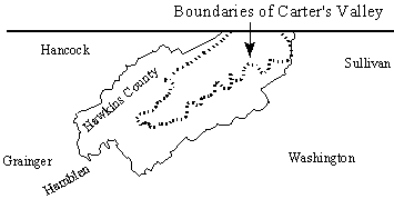
Map drawn by and ©Billie McNamara.
The Carter‘s Valley settlement probably originated just west of the present-day community of New Canton.(8)
Carter‘s Valley residents believed themselves to be in Virginia, and most of them were former Virginians.(9) Residents made improvements, but threats of Cherokee invasion caused them to leave their farms for a time. The men went to other settlements north of the Holston River, while the women and children were moved as far away as Wythe County, Virginia.(10) Settlement leaders Carter and Parker moved to Watauga.(11) Others who first made their homes in Carter‘s Valley include Joseph Kincaid, an unidentified Mr. Love, John Long, and Jonathan Mulkey, a Baptist preacher.(12) These pioneer Hawkins Countians located their homes about 15-18 miles above present-day Rogersville.(13)
Carter and Parker leased land to settlers until they learned the settlement was in North Carolina, not Virginia. Settlers refused to recognize the partners’ ownership of the land under North Carolina’s jurisdiction. Likewise, North Carolina refused to acknowledge the partners’ title.(14)
Origins of Settlers
Most of Hawkins County’s first settlers migrated from Southern Virginia. Others came from near the headwaters of the Yadkin and Catawba Rivers,(15) just east of the Blue Ridge Mountains in North Carolina (near present-day Salisbury). Members of families destined to be important in the early history of Hawkins County (and the State of Tennessee) settled nearby: the Bean and Robertson families at Watauga. and the Shelbys at present-day Bristol.(16) Transient residents of Hawkins County were found among those traveling from Virginia and other points north to the newly-opened territory in Northern Florida about 1773. Migrating settlers stopped along the Holston River and planted crops, which they later sold, and built boats for the trip downriver.(17)
A special enumeration was made in 1795 to determine if the Southwest Territory had enough residents to qualify for statehood. Hawkins County had 2,472 slaves — the largest number of any county — or nearly 20.5% of Hawkins County’s population. With 13,331 residents, Hawkins was the most populous county in the Territory.(18)
Early Forts
Wilderness conditions required the building of forts and stations in the region. Virginia built a station on the Holston River before 1758.(19) The first forts in present-day Hawkins County were located at Patterson’s Mill and Rice’s Mill, west of present-day Church Hill in Carter’s Valley.(20) Henry Rice and Robert Patterson established their residences by 1775.(21) From 1775-1795, Robert Kyle commanded a fort at the mouth of Big Creek.(22)
Land Development
The first store in Hawkins County was built by Carter and Parker(23) near present-day Church Hill to supply travelers down the Holston to British West Florida (Natchez) and to trade with Native Americans.(24) The store was robbed by Cherokee warriors. The merchants petitioned the Cherokee and were given Carter‘s Valley — from Cloud‘s Creek to Chimney Top Mountain on Beech Creek — in settlement. The deed required a small payment, made by Robert Lucas, later a partner of Carter and Parker. The agreement was reached at Sycamore Shoals, in March, 1775, during negotiations instigated by the Transylvania Company.(25)
Carter‘s Valley lands were also given to the Transylvania Company by the Cherokee through the “Path Deed,” which included lands lying “down Holston between the Watauga Lease, Col. Donelson‘s line, and Powell‘s [actually Clinch] Mountain’ as a pathway to Kentucky.”(26) The deed gave the Transylvania Company access to its 20,000,000 acres without their having to cross Indian territory.(27) Ultimately, North Carolina required that 10,000 acres be set aside for the residents of the Clinch and Powell Valleys from the lands it gave the Transylvania Company in settlement after disallowing the company’s 20,000,000-acre purchase.(28) A detailed account of the Transylvania Company’s activities is in Chapter 1 of Hawkins County Land Grant Books 1 & 2.(29)
Formation of the Transylvania Company was an important factor in the history of Hawkins County. A North Carolina attorney, Richard Henderson, organized a land-speculation consortium, comprising several noteworthy individuals.(30) The deed for the Transylvania Purchase is recorded in the Hawkins County Register of Deeds’ Office in Rogersville.(31) Many deeds, transferring land from the Transylvania Company to new owners, are also recorded in Rogersville.
Period of Significant Growth
About 1780, more stations and forts were built in Hawkins County. Later that year, the first Presbyterian Church in the county (and in present-day Tennessee) was organized. The congregation of New Providence Presbyterian Church was established by Carter’s Valley settlers at present-day New Canton near Surgoinsville.(32) New Canton had a post office by 1795.(33)
The Baptist Church was subsequently organized at Big Creek by Thomas Murrell. Settlement of the community followed.(34) Thomas Gibbons settled near the Big Creek fort in 1778.(35) Approximately 3.5 miles above present-day Rogersville and near the Big Creek fort, Thomas Amis built a stone house in 1780 or 1781. Amis opened a store, blacksmith shop, distillery, saw mill, and grist mill.(36)
William Armstrong built the first brick house in Hawkins County in the 1780’s. The future French King, Louis Phillipe, stopped at Armstrong‘s home in 1797.(37)
During this period of tremendous growth, land was cleared for cultivation by burning. When the burning got out of control, the resulting damaged area was called a “barren.” Michaux wrote of such a barren, produced during the mid-1780’s from clearing land just north of the Holston River.(38) “Barrens” are mentioned often in instruments registered in early Hawkins County land records.
Connections to the Cumberland Settlements
James Robertson, leader of the overland party to the Cumberland Settlement, lived at the Big Creek fort from 1777-1779. Robertson laid the plans for his trip at that Hawkins County site.(39) The voyage of John Donelson‘s party from Ft. Patrick Henry to the Cumberland Plateau is recorded in his journal. The group of travelers arrived in Hawkins County in December, 1779.(40) Donelson‘s journal entries detail the problems faced by early voyagers down the Holston River through present-day Hawkins County:
December 22, 1779 — Took our departure from the fort [Patrick Henry] and fell down the river to the mouth of Reedy Creek, where we were stopped by the fall of water, and most excessive hard frost; and after much delay and many difficulties we arrived at the mouth of Cloud‘s Creek, on Sunday evening, the 20th February, 1780, where we lay by until Sunday, 27th, when we took our departure with sundry other vessels bound for the same voyage, and on the same day struck the Poor Valley Shoal, together with Mr. Boyd and Mr. Rounsifer, on which shoal we lay that afternoon and succeeding night in much distress.
Monday, February 28th, 1780 — In the morning the water rising, we got off the shoal, after landing thirty persons to lighten our boat. In attempting to land on an island, received some damage and lost sundry articles, and came to camp on the south shore, where we joined sundry other vessels also bound down.
March 2d — Rain about half the day; passed the mouth of French Broad River, and about 12 o’clock, Mr. Henry‘s boat being driven on the point of an island by the force of the current was sunk, the whole cargo much damaged and the crew’s lives much endangered, which occasioned the whole fleet to put on shore and go to their assistance, but with much difficulty bailed her, in order to take in her cargo again. The same afternoon Reuben Harrison went out a hunting and did not return that night, though many guns were fired to fetch him.(41)
The first 100 miles of the trip took approximately two months to complete. In 1789, the North Carolina legislature established a storehouse for provisions for the Cumberland Guard, who escorted families to the Cumberland Settlements. The storehouse was at the home of John Adair, in Hawkins County.(42)
Government by Virginia
Settlers in the Carter‘s Valley and Long Island areas were organized into the Pendleton District of Virginia before 1776. After several petitions to the Virginia Legislature, the District was included in Fincastle County, Virginia. These same settlers facilitated the organization of Virginia’s Washington County in 1776. Washington County, Virginia, encompassed southwestern Virginia and the North Holston and Carter’s Valley Settlements in present-day Tennessee.(43) In 1777, residents of the Tennessee-area settlements gathered at Patterson‘s and Rice‘s Mills in Hawkins County for a special, unidentified enumeration.(44)
Although it became annexed to North Carolina, some of Hawkins County continued to be administratively part of Washington and Fincastle Counties, Virginia, in many actions (e.g., wills, executed by Carter‘s Valley residents, were recorded for probate in Fincastle County, Virginia).(45)
Government by Franklin
During the existence of the State of Franklin,(46) that state’s legislature formed several new counties in present-day East Tennessee. Spencer County was formed in 1785 from parts of Sullivan and Greene Counties “lying west of the North Fork of the Holston.”(47) Spencer County had roughly the same boundaries as present-day Hawkins County. Franklin appointed Thomas Henderson Clerk of the Spencer County Court and Spencer’s Colonel of the Militia. William Cocke and Thomas King were representatives from Spencer to the Franklin Assembly.(48)
Government by North Carolina
Growing concerns during the Revolutionary War moved residents of the Watauga Settlement to petition North Carolina for annexation to that state in 1776.(49) Several future Hawkins Countians were signers of that petition.
Washington County Formed
The North Carolina legislature set out its existing District of Washington before January, 1776.(50) From that District, North Carolina formed Washington County. The boundaries of the new Washington County, North Carolina, were roughly equivalent to those of the present-day State of Tennessee.(51) Carter’s Valley was, for many years, the westernmost settlement of North Carolina’s western territory.(52)
Greene County Formed
In 1779, North Carolina divided Washington County into two smaller, more manageable counties. Washington County retained its name; the new county was named Sullivan. In 1783, North Carolina again divided Washington County, creating Greene County.(53) The boundaries of Greene County were set out as follows:
Hawkins County Formed
At its 1786 session, the North Carolina legislature divided Greene and Sullivan Counties to form Hawkins County.(55) The boundaries of Hawkins County, North Carolina, were roughly the same as those of Franklin’s Spencer County.(56) As with the co-existing Spencer County,
Hawkins County included “all that part of the territory lying west of the north fork of Holston.”(57) North Carolina clearly ignored the United States’ Treaty of Hopewell when it erected Hawkins County:
…county of Sullivan be divided in the following manner, beginning where the boundary line between the Commonwealth of Virginia and the State of North Carolina crosses the North Fork of Holston River, thence down said fork to its junction with the main Holston River, thence across said river due south to the top of Boyes [Bays] Mountain, thence along the top of the said mountain and the top of the dividing ridge between the waters of Holston River and French Broad River to its junction with Holston River, thence down said river Holston to its junction with the Tennessee River, thence down the same to the Suck where said river runs through the Cumberland Mountain, thence along the top of said mountain to the aforesaid boundary line, and thence along said line to the beginning; and that all that part of Sullivan county on the east side of the North Fork of Holston River shall continue and remain a distinct county by the name of Sullivan; and all that other part which lies west of said North Fork of Holston shall thenceforth be erected into a new and distinct county by the name of Hawkins.
Most published material on the formation of Hawkins County indicates the bulk of its land came from Sullivan County; however, a comparison of the 1783 county boundary lines clearly shows that more territory came from Greene than from Sullivan.(58)
Hawkins County was named for Benjamin Hawkins, a member of the Continental Congress, a United States Senator from North Carolina, and a member of the commission that negotiated the Treaty of Hopewell for the United States. Hawkins was one of the signers of the deed transferring North Carolina’s western lands to the United States.(59) Hawkins County was organized by 1787;(60) its County Court first met at the home of Thomas Gibbons.(61) Gibbons‘ home served as the “courthouse” simultaneously under the jurisdictions of North Carolina and Franklin. The present Courthouse in Rogersville, built in 1836, was preceded by a large, hewn-log structure.(62)
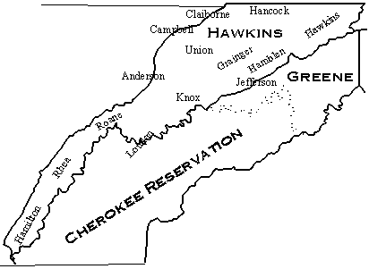
Hawkins County in 1786. Map drawn by and ©Billie McNamara.
Founding of Rogersville
One of North Carolina’s last legislative acts specifically directed at its western lands was the establishment of a town in Hawkins County. Rogersville, founded in 1789, was the last Tennessee town founded under the government of North Carolina.(63) The town was named for Joseph Rogers, an Irish immigrant who arrived in present-day Rogersville in 1786. Rogersville was laid out by commissioners appointed in 1789 by North Carolina: Thomas King, Thomas Hutchings, Joseph McCulloch, Thomas Jackson, and Elijah Chisholm.(64) The city’s first elected officials were Thomas Hutchings, Hutson Johnston, Francis Doherty, Joseph Cloud, and Thomas Gibbons.(65)
Government by Southwest Territory
With the acceptance of North Carolina’s second cession by the United States Congress, Hawkins County became a part of the Territory of the United States South of the Ohio River — the “Southwest Territory” — in 1790. On October 10, 1790, the territorial governor arrived to assume his duties. William Blount boarded at the home of William Cobb, near the present-day town of Rogersville, until the seat of the territorial government was established. Although early governmental functions occurred in Rogersville, Knoxville was finally chosen as the site.(66)
As governor of the Southwest Territory, Blount faced a difficult task. Most of the land entered and resided upon by Hawkins County inhabitants violated the boundary lines established by the Treaty of Hopewell and treaties entered into by North Carolina. Some settlers lived west of the Clinch River and south of the French Broad and Holston Rivers — both areas that were reserved for Cherokee settlement. The settlers maintained that their lands had been relinquished by the Cherokee in treaties with the State of Franklin; however, North Carolina and the United States refused to acknowledge those treaties.(67)
Establishing the State of Tennessee
Representatives of Hawkins County at the Tennessee Constitutional Convention in 1796 were James Berry, Thomas Henderson, Joseph McMinn, William Cocke, and Richard Mitchell.(68) Cocke and Henderson were chosen as Hawkins County’s representatives to assist in drafting the new Constitution.(69) John Cocke and Thomas Henderson were the first Hawkins County members of the Tennessee House of Representatives.(70) Joseph McMinn was later Governor of Tennessee.
Military Activity
The year 1779 was pivotal for both North Carolina and Virginia. One of the major events occurred when the states ordered militia troops to fight the Chickamauga near present-day Chattanooga. The troops rendezvoused about four miles above present-day Rogersville.(71)
Significant battles involving Hawkins Countians include Point Pleasant and King’s Mountain. Point Pleasant, (also called “Battle of Kanawha”), a battle in Lord Dunmore’s War of 1774(72) was the first battle with Native Americans that involved troops from Tennessee.(73) King’s Mountain, fought near Cowpens, South Carolina, was probably the turning point of the Revolutionary War in the South.(74)
The list of future Tennesseans who fought in the Revolutionary War includes a number of Hawkins County residents. Likewise, many Hawkins County men fought against the Indians, most notably with Joseph Martin against the Chickamauga (1788).(75) James Robertson, known as the “Father of Tennessee,” and Tennessee’s first Governor, John Sevier, also commanded Hawkins County troops in these battles.(76)
Commercial Development in the 18th Century
The earliest commercial venture in most areas of East Tennessee was probably the establishment of a grist mill. Two mills, Rice‘s and Patterson‘s, were active in Hawkins County before 1775.(77) In 1779, a makeshift boat yard opened near the mouth of Big Creek. Giant poplars were cut for miles around; their trunks were hollowed out to make canoes. Flatboats and barges were also constructed.(78)
Hawkins County was home to an interesting commercial venture, perhaps the only one of its kind in East Tennessee. A horse racing track was built in the 1790’s between Poor Valley Creek and Red Bridge.(79)
The first printing press in East Tennessee was installed by George Roulstone, in 1791, at Hawkins’ Court House (later Rogersville). Roulstone had moved the press across the mountains from his former home in Fayetteville, North Carolina. For approximately one year, Roulstone published the Knoxville Gazette from Hawkins County. Roulstone stopped in Hawkins County because Knoxville’s development
“was not yet sufficiently advanced.”(80) This is quite different from a modern comparison of the two cities.
After moving to Knoxville, Roulstone also served as Postmaster. As such, he handled mail for most of East Tennessee. Everyone traveling through the territory was an ad hoc mail carrier. Roulstone also opened a private postal service, with the goal of increasing subscriptions to his newspaper. This regular post connected Hawkins County residents to those in neighboring counties on a weekly basis:
He will set out every other Monday, and go by Maryville to Sevierville; from thence, by Dandridge, to Hugh Neilson‘s, Esq., on Lick Creek; from thence to Hawkins’ Court-House; and from thence, by Haine‘s Iron Works, crossing at McBee‘s Ferry, to Knoxville.
The route was expected to be extended as subscribers were added.(81)
Iron played an important role in the development of upper East Tennessee. A large ironworks was established by Daniel Ross and Company, in Hawkins County about 1795, near the present-day community of Rotherwood.(82) A number of the earliest deeds recorded in Hawkins County were for mineral rights. Others were for purchases made by known speculators, apparently hoping to exploit the iron. Many of these speculators were from Pennsylvania and Maryland.(83) Before iron was mined locally, it was imported from forges in North
Carolina and sold for “an enormous price.” It was saved for use in building or repairing farm equipment.(84)
Early times were difficult in the new territory. Because of the lack of roads, wagons were not used in Tennessee until 1776.(85) Many settlers crossed the Holston River at Dodson‘s Ford, which was located where the Great War and Trading Paths crossed the Holston River. This location is near where U. S. Highway 70 crosses the Holston River today. Rodham Kennar, a German immigrant, operated a ferry above Dodson‘s Ford.(86)
Pioneers did without tools, mechanical equipment, and even salt, which was brought in by pack mules from Augusta and Richmond, Virginia, and sold for as much as $10 per bushel.(87) Corn was first planted in the Cumberland and Nolichucky Settlements in 1790; it quickly became Tennessee’s primary crop.(88) The log cabin, because of its simple construction, was the natural dwelling. Many cabins had only dirt floors.(89) A detailed description of many aspects of pioneer life in Tennessee can be found in pages 714-737 of Ramsey‘s Annals of Tennessee, pages 130-150 of Rothrock‘s This is Tennessee: A School History, and pages 29-83 of White‘s Tennessee: Its Growth and Progress.
References and Endnotes
When viewing notes from within the text, press your browser’s back key to return to the text.
1. Goodspeed Publishing Company, History of Tennessee (Nashville, TN: Goodspeed Publishing Co., 1887; reprint ed., Nashville, TN: Charles & Randy Elder Booksellers, 1972; reprint ed., Hartford, KY: McDowell Publications (East TN Counties; includes index); reprint ed., Greenville, SC: Southern Historical Press, 1979), 873.
3. Louis T. Ketron, Historical Map of Hawkins County, 1771-1971 (no publication data; 1971), note 145.
5. Holston Territory Genealogical Society (HTGS), Families and History of Sullivan County, Tennessee (Marceline, MO: Walsworth Publishing Co., 1993), 4.
6. Stanley J. Folmsbee, Robert Corlew, and Enoch Mitchell, Tennessee: A Short History (Knoxville: University of Tennessee Press, 1976), 54.
7. Will T. Hale and Dixon L. Merritt, A History of Tennessee and Tennesseans (Chicago and New York: Lewis Publishing Company, 1913), 1:41-42.
8. Ketron, note 147. 9. J. G. M. Ramsey, The Annals of Tennessee … (Charleston, SC: Walker & Jones, 1853; reprint ed., Philadelphia, PA: Lippincott, 1860; reprint ed., Kingsport, TN: Kingsport Press, 1926 and 1967), 111.
11. Folmsbee, Corlew, and Mitchell, 55.
16. Mary U. Rothrock, This Is Tennessee: A School History (Knoxville, TN: By the Author, 1970), 79.
20. Pat Alderman, Overmountain Men: Battle of King’s Mountain, Cumberland Decade, State of Franklin, Southwest Territory (Johnson City, TN: Overmountain Press, 1969), 29.
21. Ketron, notes 148 and 157.
22. Ibid., note 117; Goodspeed, 873.
24. Folmsbee, Corlew, and Mitchell, 55.
25. Hale and Merritt, 1:23; HTGS, 5; Goodspeed, 873; Ramsey, 119.
27. Folmsbee, Corlew, and Mitchell, 59.
28. Ramsey, 760; Hale and Merritt, 1:22-23.
29. Billie R. McNamara, Hawkins County Land Grant Books 1 & 2, 1787-1819 (Knoxville, TN: By the Author, 1996).
31. Hawkins County Deed Book 1, page 146.
32. Goodspeed, 873; First Tennessee-Virginia Development District, Historic Sites Survey (Bristol?, TN: By the District, 1977), 10; Ketron, note 149.
38. Samuel Cole Williams, History of the Lost State of Franklin (Johnson City, TN: Watauga Press, 1924), 249.
45. Prentiss Price, “Index to Wills of Hawkins County, Tennessee, 1786-1850,” Tennessee Ancestors 6 (1990): 23. Extant records for Fincastle County, Virginia, are archived at Abingdon, Virginia.
46. See Chapters 1 and 4 for more information about the State of Franklin.
47. “County of Spencer?,” undated and unidentified newspaper clipping in “Hawkins County Through 1949” topical file at the McClung Historical Collection in Knoxville, TN.
51. Mary U. Rothrock, ed., French Broad-Holston Country (hereinafter FB-H) (Knoxville: East Tennessee Historical Society, 1946 and 1972), 42.
54. René Jordan, “The Evolution of Early Tennessee County Boundaries: Greene County and Davidson County,” Tennessee Ancestors 10 (1994): 197.
55. Rothrock, FB-H, 29 and 42.
58. René Jordan, “The Evolution of Early Tennessee County Boundaries: Hawkins County and Sumner County,” Tennessee Ancestors 11 (1995): 5-6.
62. “Joseph Rogers Walker, Grandson of Rogersville’s Founder, Tells of Past in Hawkins and Sullivan,” Kingsport Times, 24 February 1929 (clipping in “Hawkins County Through 1949” topical file at the McClung Historical Collection, Knoxville, TN).
64. C. C. Justus, “Hawkins County Land Once Sold by Indians for 25 Cents an Acre; Mother of Journalism and Judges,” Knoxville News-Sentinel, 30 December 1923 (clipping in “Hawkins County Through 1949” topical file at the McClung Historical Collection, Knoxville, TN).
72. Ramsey, 115-116; Williams, 113; HTGS, 13.
75. Lists of Hawkins County soldiers have been published in several books and periodicals, most notably the East Tennessee Historical Society’s Tennessee Ancestors, the Hawkins County Genealogical Society’s Distant Crossroads, and Pat Alderman’s Overmountain Men.
77. Ketron, notes 148 and 157.
82. Goodspeed, 875; Ketron, note 177, gives the date as “by 1790.”