
1836 Civil Districts Map — Amazing Resource!
For years, this site’s Webmistress has wished for a map of the Hawkins County Civil Districts in 1836, overlaid on a current map, for her own research.
She is immeasurably grateful for the incalculable efforts of Jim Jackson for his having created just such a map.
Jim not only created the map, he created a single, combined list of names from the 1830 Census, 1840 Census, and 1836 Tax List for Hawkins County.
This is an important resource for Hawkins, Claiborne, Hancock, and Grainger County researchers.
Click the map image below to visit Jim Jackson’s site and view his work.
Thank you, Jim!
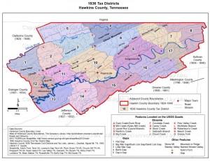
Click this reduced-size map image to visit Jim Jackson’s site and view a larger version.