1836 Civil District Boundaries
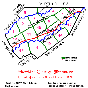
This map shows Hawkins County’s Civil Districts as they were first laid off on 23 July 1836. Note that portions of the 1836 county are now in Hancock and Hamblen Counties.
In 1834, the Tennessee Legislature enacted a requirement that each county be divided into Civil Districts, rather than the Militia Companies that had existed previously. For information about some 20th Century changes to Hawkins County Civil Districts, see Hawkins County Private Acts.
Numerous 19th Century legislative acts altered the boundaries of Hawkins County. Details of those and selected other Hawkins County-specific Acts are in Henry D. Whitney’s Land Laws of Tennessee, published in 1891. Click here to view Whitney’s work at Google Books.
The following text was transcribed by Billie McNamara in 1996 from a handwritten document on file at the Tennessee State Library & Archives in Nashville. No spelling or grammatical changes were made.
State of Tennessee }
Hawkins County }
We the undersigned Commissioners being appointed to lay off the County aforesaid into Convenient Districts for the purpose of electing Justices of peace Constables &c have proceeded to lay off the same as hereinafter set forth to wit
District No 1
Beginning on the top of Clinch mountain at the Flat Gap thence with the road by George Wolfs and to John Greens leaving John Green to the west thence along a path to Duck creek near AEneas Matthews‘s old place thence down said creek to the mouth then down Clinch river to the Grainger County line thence with said line to the Clinch mountain thence along the same to the Beginning.
The Election to be held at the house of William Walker.
District No 2
Beginning on the top of Clinch mountain at the Flat Gap thence with the road by George Wolfs and to John Greens leaving John Green to the west thence along a path to Duck Creek near AEneas Matthews‘s old place thence down said creek to the mouth thence up the river to the upper end of William McCullough‘s plantation thence with the path to Richard Trents thence with the path through the Knobs to Wm Copes Senr & to Wm Birds thence by Wm Birds Spring thence up the point of the Copper ridge to the road thence with the road to Thomas Martins Senr thence with said road to the top of Clinch mountain at the Buck lick Gap thence westwardly along the top of the mountain to the Beginning.
The Election to be held at James Murrels.
District No 3
Beginning on the top of Clinch mountain at the Buck lick Gap thence with the road to the mountain valley road then up the road through Thomas Martins lane thence along a road that leads to Wm Copes and down a Spur of the Copper ridge to Wm Birds spring thence to the road by Wm Copes thence with a path through the Knobs to Richard Trents thence with the path by the Buckeye Spring to Clinch river thence up the river to the mouth of Kyles mill creek thence up the creek to the ford below James Collins‘s thence with the road to the top of Clinch mountain at the little War Gap thence along the top of the mountain to the Beginning.
The Election to be held at the House of John Manis.
District No 4
Beginning on the top of Clinch mountain at the Little War Gap thence with the road leading to Lee to the ford of the Creek below James Collins‘s then down the Creek to the river thence up the river to Kyles ford thence cross the river and with the road by John Wallens to a small schoolhouse thence a due north course to the Virginia line thence eastwardly with said line to the top of Clinch mountain thence along the top of the same to the Beginning.
The Election to be held at the house of George Anderson.
District No 5
Beginning on Clinch river at Kyles ford thence along the road leading to Lee by John Wallens to a small schoolhouse thence a due north course to the Virginia line thence westwardly with said line to the Claiborne County line thence with said line to Clinch river at the mouth of Greasy rock thence up the river to the beginning.
The Election to be held at the house of Jacob Delp.
District No 6
Beginning on the north bank of Holston river opposite the mouth of the laurel branch below Thomas Morrisons running with the road that leads from said Morrison‘s to Doctr Walkers to where said road crosses Ellis‘s Branch then up said Branch crossing the stage road a little west of said Ellis‘s house then up the Branch to Campbell Smiths then along the road that leads from said Smith to the east of Robert Henseleys then with said road to Coopers mill creek then up said creek to the fork below Coopers mill then up the west fork of said creek to John Forgeys mill then with the path that leads from Forgeys mill across the Stanley valley Knobs to intersect the Virginia line below Henry Larkins‘s and Henry Doiters (?) the [sic] east with the Virginia line to the north fork then down the north fork to the mouth then across the river Holston and with the Sullivan County line to the top of the river mountain then along the top of said mountain to the head of the Laurel Branch and down said branch crossing the river to the Beginning.
The Election to be held at James Francisco‘s.
District No 7
Beginning on the river opposite the mouth of the Laurel Branch then down the river to the mouth of Renfroes Creek thence up said creek to the fork then up the west fork to the Carter‘s valley road between James Amis‘s and Bartram Galbreaths then up the Creek by John Mocks then crossing the Stanley valley Knobs with the path between Benoni Coldwells and Walters‘s and running with the line that divides the lands of Coldwell and Walters to the Virginia line and Clinch mountain east of John Deckard then with the Virginia line east to the corner of District No 6 and with that line to the beginning.
The Election to be held at the house of John Winn.
District No 8
Beginning at the mouth of Renfroes creek thence down the river to the mouth of Big creek then up said creek to the mouth of John Carmacks Spring Branch then up said Branch to the road that leads up Stanley valley then along said road to Cornelius Carmacks Spring thence crossing Big creek and running to the top of the Stanley valley Knobs then along the top of said Knobs to the line of District No 9 nearly opposite Bennoni Coldwells plantation at the Gap between said Coldwells and Walters‘s then with said line to the Beginning.
The Election to be held in Surgoinesville.
District No 9
Beginning on the top of the Stanley valley Knobs at the gap between Bennoni Coldwells and Walters at the corner of District no 8 running thence with the line of the same and along the top of said Knobs to Big creek opposite to Cornelius Carmacks Spring then crossing the creek to the Stanley valley road then along said road to the road that leads through the Caney creek Knobs at Molsbys Gap continuing along said road through William Molsbys lane to intersect the little War gap road near Spencer Acuffs field then along the road to the corner of the fence of the lot that included said Acuffs house thence a straight line to the creek leaving said Acuff to the west of said line thence up said creek & to the top of the Chesnut ridge then a straight course to the top of Clinch mountain leaving Pleasant Starnes Andrew Spears Hays Lewis and David Patterson to the west of said line then along the top of said mountain to the corner of Lot no 8 thence with the line of said Lot No 8 passing the line that divides Coldwell and Walters tracts of land to the Beginning.
The Election to be held at Arthur Galbreaths house in Stanley valley.
District No 10
Beginning at the mouth of Big creek and running down the river to the mouth of Crocketts creek thence up said creek to the mouth of the lane that divides the lands of Lazarus Lawson and James McClure then along said lane to the stage road crossing the same and with the dividing line of said Lawson & McClure to the top of Caney creek Knobs then a straight line to the mouth of the lane that divides the lands of Daniel Lipe and Thomas Ingram then through said lane crossing caney creek and following the road and passing the house where Oneill formerly lived leaving said house to the east and following the path that leads from Oneills to Wax‘s plantation on Stock creek where Henry Blevins formerly lived thence along the path towards the Flag pond until it intersects a path that Orville Rice and Robert D Young opened to go to the Sulphur Spring thence along said path to the road that leads from Rogersville to the Sulphur Spring thence with said road crossing the stone mountain to the Sulphur on little poor valley creek thence down said creek to the saltworks gap in Pine mountain thence through gap to Powels salt works thence with the road to the top of Clinch mountain at the Sand Lick gap thence with the top of the mountain eastwardly to the corner of district No 9 to the little war gap road east of Spencer Acuffs house then with the road and line of district No 9 passing through Molsby‘s gap to the Stanley valley road and with said road to John Carmacks Spring Branch thence down said Branch to Big creek thence down said creek to the Beginning.
The Election to be held at Rogersville.
District No 11
Beginning at the mouth of Crockets creek and running down the river to the mouth of Andrew Galbreaths Branch thence up said Branch to the forks and up the west fork to the foot of the Short mountain and on the same course to the top of said mountain then westwardly along the top of said mountain to the ridge that connects the stone mountain with said Short mountain thence along said ridge passing the head of Clouds creek and thence a straight course to the mouth of McAlister‘s branch on poor valley creek thence up said Branch to the head thence a direct line to the top of Clinch mountain thence along the top of the same to the Sandlick gap corner to District no 10 thence down the path to Powels Saltworks thence crossing Pine mountain at the Saltworks gap to little poor valley creek thence up the creek to the Sulpher Springs thence up to the top of Stone Mountain then along the road to Orville Rice‘s & Robert D Youngs road and with said road to the Flag pond thence along a path to Jacob Wax‘s plantation on Stock creek where Henry Blevins formerly lived then with a path to the house where Oneill formerly lived then with the road crossing caney creek to the mouth of the lane that divides the lands of Thomas Ingram and Daniel Lipe thence with said lane with the line of district No 10 across caney Knobs to the dividing line between James McClures and Lazarus Lawson to Crocketts creek thence down said creek to the Beginning.
The Election to be held at Chusly (?) Shank‘s.
District No 12
Beginning at the mouth of Andrew Galbreaths Branch and running thence down the river to the Grainger County line then with said line northwardly to the top of Clinch mountain thence along the top of said mountain eastwardly to the corner of District No 11 then with said line down Clinch mountain to the head of McAlisters branch then down said Branch to Poor valley creek then crossing said creek and up to the top of Stone mountain and along the ridge that connects the stone mountain with the short mountain to the top of said mountain then along the top of said mountain to opposite Galbreaths Branch then to said Branch and down said Branch to the Beginning.
The Election to be held at Hugh G Moores at Mooresburg.
District No 13
Beginning on Holston river at C Eskridg Kenners ferry thence with Kenners ferry road to Mount Sterling & to the Jefferson County line and thence along said line to the Grainger County line and then with said line to Holston river thence up the river to the Beginning.
The Election to be held at the Rock House Spring at Joseph White‘s old place.
District No 14
Beginning at C Eskridge Kenners ferry and running up the river to the mouth of Robertsons creek thence up the creek to Aaron Mooney‘s leaving him on the west side then with the plain road on by the two widow Mooney‘s to the Bulls gap road then with said road and same pathway leaving John Dodson and James Long to the east and thence to the foot of Bays mountain to the new road at Days gap leaving John West to the east thence with said new road to the Greene County line then with said County line and the Jefferson County line to Mount sterling thence to the Beginning.
Election to be held at James Walkers.
District No 15
Beginning at the mouth of Robertsons creek thence running up the river to the mouth of Beech creek thence up said creek to Ogborn Hales thence along a path leading across grassy Mountain at Manis‘s gap to the road in the valley leading from John Millers mill to David Harmans (?) and thence with said road to the dividing line between David Harmans (?) and Ephraim Morris and with said line to the creek that runs down by Thomas K Coldwells then up said creek leaving said Coldwells house on the east thence following a path leading from the said Coldwells to where William Vernon formerly lived and thence to the Greene County line on the top of Bays mountain then with said County line Westwardly to the corner of District No 14 at Days Gap then with the road leaving John West James Long and John Dodson on the east then running by the two widow Mooneys to Robertsons creek at Aaron Mooneys thence down said creek to the Beginning.
The Election to be held at Peter Smith‘s.
District No 16
Beginning at the mouth of Beech creek and running up the river to the ford of the river above Surgoinesville in Rachael Armstrong‘s field thence a straight course across said Plantation to the road that leads across Alex‘s [Eleck’s] mountain to Big Bill Staceys then with said road to the top of said Alex‘s [Eleck’s] mountain then along the top of the same to opposite the dividing ridge between the head waters of the Grassy creek and the north fork of Beech creek thence along the said dividing ridge leaving Jordan Hensley to the west and running on the said dividing ridge between the south fork of Beech and Horse creek and continuing on the same direction to the Washington County line leaving John Dykes west of said line thence with said line and the Greene County line to the corner of District No 15 then with the line of said District passing by where Wm Vernon formerly lived and with the path to Thomas K Coldwells and thence down the creek to the line between David Harman (?) and Ephraim Manis and with said line to the road leading to John Millers mill then with said road to the path that leads across the grassy mountain at Manis‘s Gap then with said path to Beech creek at Ogbourn Hales and thence down said creek to the Beginning.
The Election to be held at James Tunnels Senr.
District No 17
Beginning at the ford of the river in Rachael Armstrong‘s plantation running a straight line to the road that leads across Alex‘s mountain to Big Bill Staceys and with said road to the top of Alex‘s [Eleck’s] mountain then along the top of the same to opposite the dividing ridge between the head waters of Grassy creek and the north fork of Beech creek thence along the said dividing ridge leaving Jordan Hensley to the West and running on the said dividing ridge between the south fork of Beech creek and Horse creek and continuing on the same direction to the Washington County line leaving John Dykes west of said dividing line in District no 16 thence with said Washington and Sullivan County line eastwardly to the corner of District no 6 on the top of the river mountain thence down the mountain on the line of District no 6 to opposite the head of the laurel branch thence down the said branch to the river thence down the river to the Beginning.
The Election to be held at Alexander Smith Senr.
Given under our hands this 2nd day of February 1836.
G. McCraw
Richard Mitchell
J. Mitchell
John Reynolds