I was contacted this July 2014 by William Martin, a descendant
of Adam Dale. He told me about knowing the location of the Pioneer
Cemetery, possibly the oldest cemetery in DeKalb County:
"The Pioneer Cemetery is located in a clump of trees high on the bank
above US 70 at the intersection with the Liberty to Dismal
Road. It is above the original location of the Tennessee
State Adam Dale Historical Marker (Which has been stolen some 5 years
ago). For the record the GPS coordinates are 36* 0' 35.22" N and 85*
58' 03.55" W. I have been there many times, and I was last
there maybe 2 years ago and was able to locate several graves and
boxes. I was first shown the location by my aunt Genelle
Martin Dodd, lifelong resident of Liberty, some 50 years ago. I
remember her saying the cemetery site was selected facing the rising
sun as was the custom. It is the oldest non-native cemetery I
know of in Dekalb Co., some burials documented before 1809. I
have some relatives John and Matilda Woodside buried 1850-1860 there
but they were certainly not the first."
From Hale's History of Dekalb County, which contains the only known
recording of graves still available:
"There is one other landmark demanding
notice, the pioneer cemetery on the northwest edge of Liberty. It is
referred to by H. L. Hale as the "old Methodist graveyard." It lies on
a gentle slope facing the sunrise, and at one time it must have been a
beautiful spot. Pathos now hovers over it. But few stones are standing,
and these are the stone pens covered with broad slabs of carefully
worked limestone. Not a flower can be seen in the most gorgeous summer
save the wild rose. No one walks there to meditate over the departed. A
century ago children's voices were heard, and relatives of the dead
walked among the tombs to pay the tribute of a sigh. Now nobody cares.
James H. Burton writes: "My grandfathers, Ebenezer Burton and John S.
Woodside, my father and mother, W. H. and Nancy Burton, and Uncle John
Woodside are buried there." H. L. Hale writes: "Few names on the two or
three tombs are legible. On a little 'house of rock,' the last home
evidently of a husband and wife, this only could be read: ' -----
Daugherty. Born 1770, died 1828.' Near by was this: ' Caroline Arnold.
Died July 22, 1828.' On another tomb: ' D.E.S. Kenner. Died December 4,
1809; age seventy-seven years.' One other: ' Nancy Fite, born 1805;
died July 22, 1828.' Judging from the grave of D.E.S. Kenner, the
cemetery was used at least one hundred and five years ago, and the
slumberer was born the same year Washington was, 1732."
A historical marker for Adam Dale was placed on the Liberty to Dismal
Road close to the intersection with Highway 70, and on the east side of
Highway 70. This Liberty to Dismal Road is nearly across from Congress
Street, which is on the west side of Highway 70 in Liberty. The Liberty
to Dismal Road starts there within just a few feet of the Highway 70
bridge crossing Smith Fork. Across the Dismal Road from Smith
Fork is the former location of the Adam Dale historical marker and
above that is the cemetery on the side of a hill in a clump of trees,
no
more than a strong stone's throw from the road.
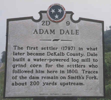
The Adam Dale Historical marker placed by the state of TN is now lost
(Does anyone know who took it, or if it can be returned? I heard it had
been knocked down several times and then became missing. The state will
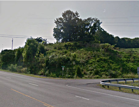
not pay to replace it.). Here is a photo of that historical marker, and
in the photo you will see a clump of trees rising in the background on
the hill behind and to the right of the marker. The cemetery is there.
To the left margin of the photo is Highway 70 westbound (toward
Alexandria) in view, showing the closeness to the intersection. The
photographer's back would be toward Smith Fork.
Will T. Hale mentions in his history that Adam Dale's grist mill was
just 200 yards upstream, which would be in the direction going west and
across Highway 70. He also says that the cemetery was referred to
as the Methodist graveyard, it does not seem that there was
ever a church next to the cemetery. The oldest grave there of record
was in 1809, and the Methodists did not build a Church in the Liberty
area until about 1835. There were Methodists in the area earlier as
evidenced by denominational records of circuit preachers being assigned
to an area that would include Liberty. It appears that if the
Methodists did claim it, it was after several burials had already
occurred.
The
first known burial was in 1809, and until 1806 the Holston Treaty line
dividing Indian lands from the settlers was right there in that Smith
Fork Creek. Anything located south of that Creek there at that spot on
Highway 70 would have been Indian lands and off-limits to the settlers.
Below is a Google map that has been marked to show GPS tracking of the
path that William Martin walked in visiting that cemetery. The pins
show where he started and ended at Dismal Road.
"The photo shows where I started (parked car) and where I
ended. The destination (Pioneer Cem) is where it shows I
walked around the existing graves (the blue rectangle and triangle)."
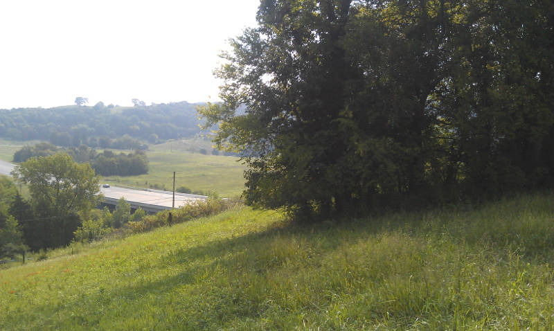
View
facing westbound Highway 70. Large tree is the
Cemetery.
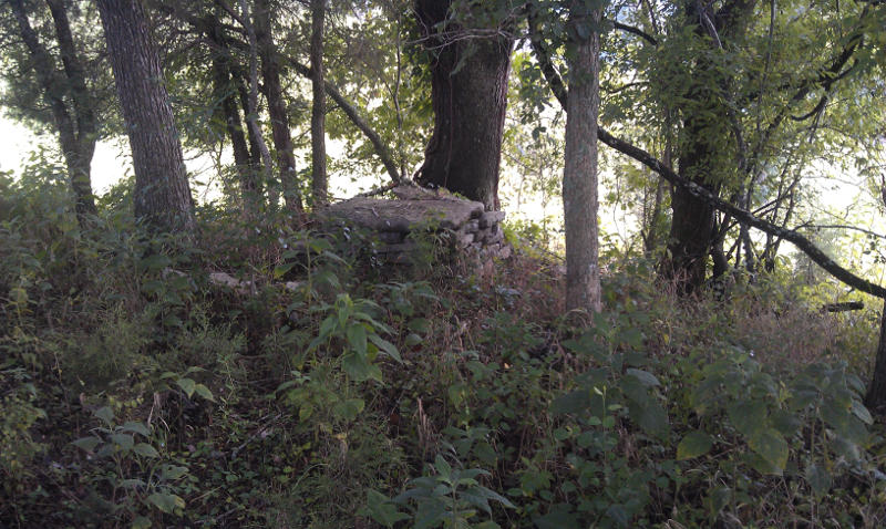
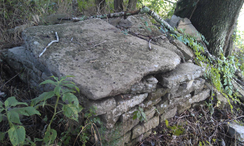
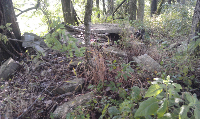
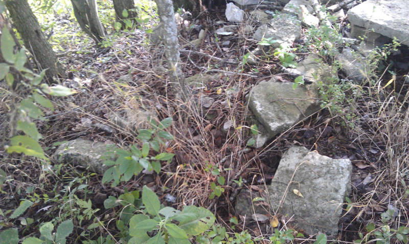
Cemetery Photos
Photos by Bill Martin: "There is one stone vault of sorts that is the most
remarkable of the graves. You can find many pieces of grave markers covered
in grass and weeds scattered over the whole wooded area. I estimate the
wooded area to be 40 feet by 100 feet in area with only one tree possibly
old enough to be there when the cemetery was last used for burial. I am
sorry to say not a single inscription is visible... I think I remember a
couple of inscriptions being visible on my first visit some 40-50 years ago."
The cemetery is in the trees to the right. View is toward Smith Fork bridge on Highway 70.