
Colonial Period Indian Land Cessions
in the American Southeast
and Related Documents
An Overview
Part Two
Page Contents.
(Links to Paragraphs)
Treaty of Lochaber, South Carolina, 1770Part One
Wataugah Lease of Cherokee Land, 1772
Lord Dunmore’s War, 1774
Henderson’s Purchase (Transylvania Land Company), The Treaty of Sycamore Shoals, 1775
The Wataugah Purchase, 1775
The Jacob Brown Purchases, 1775
The Shawnee Question, or Who Owned Kentucky?
Treaty of 1777
Cumberland Compact, 1780
Revolutionary War, 1776-1784. End of Colonial Treaties
The State of North Carolina’s Indian Policy, 1783
Continental Congress, 1781 (Article VI)
Continental Congress, 1781 (Article IX)
A Federal Ordinance, 1786
Constitution of the United States of America, 1787 (Article I, Section. 10)
State of Franklin, 1784-88
Treaty of Dumplin Creek, 1785-1786
North Carolina relinquishes rights to her “Western Lands,” 1789
Territory of United States south of the River Ohio a.k.a. Southwest Territory, 1790
Southwest Territory become the state of Tennessee, 1796
The Aboriginal People of Tennessee to King George III & Company, 1768
Evading the 1763 Proclamation : The Greenbrier and Loyal Companies
Evading the 1763 Proclamation
The Greenbrier and Loyal Companies
[The Virginia legislature appointed as their representatives for treaty matters, Col. Andrew Lewis, head of the Greenbrier Company, and Dr. Thomas Walker, head of the Loyal Company.]
“ . . . After the Treaty of Fort Stanwix in 1768, which established the boundary lines to the north of Virginia, Lord Shelburne in London was anxious to settle the entire western frontier in order to avoid Indian wars. He ordered John Stuart, superintendent of Indian affairs for the southern department, to fix the frontier to the south. Lewis and Walker, the Virginia commissioners, wanted to move the boundary as far west as possible in order to make legitimate the claims of the Greenbrier and Loyal companies. John Stuart, however, agreed with the Cherokee chiefs that the line of the boundary should run to the mouth of the Great Kanawha River in what is now West Virginia, rather than farther west to the Ohio River alongside what we now call Kentucky. The Virginia commissioners worked through their political friends and the House of Burgesses passed a request that Stuart move the boundary to the Ohio River. The royal governor, however, had no choice but to back the superintendent of Indian affairs and, with the reluctant signatures of Lewis and Walker appended, the Treaty of Lochaber, South Carolina, in 1770, established the line at the Great Kanawha.
“Then an odd thing happened. By agreement with the Cherokee chiefs, for ‘a promise of £500 that was never paid,’ the line was moved west to the Ohio River after treaty signing. It was obvious that much rum flowed. John Stuart did not object since the change was made with the consent of the Cherokees themselves. It is not difficult to guess who offered the money to the Cherokee chiefs, for the line of the Loyal Company claim now was extended even beyond the original grant.
“Dr. Walker, apparently in fear of reversal by the Privy Council, went to work immediately. By December 16, 1773, some 980 surveys were made, on which basis 201,554 acres of land, slightly more than one-quarter of the original grant, were sold. Thomas Walker had succeeded, unlike the Ohio Company shareholders, in thwarting the declared policy of the British Crown. This was due to his close contacts with the Virginia legislature, many of whose members had a personal interest in his success. Indeed, the Virginia council was so subservient to Walker that when settlers established themselves on land that the Loyal Company no longer owned, after the revocation of the patent in 1763, the sheriff was ordered to remove the offenders unless they purchased their land from the company. In effect, settlers who by Virginia law had a preemptive right to fifty acres, were forced to buy land they had already improved from a company whose charter had lapsed. This would have been impossible, the evidence indicates, if it were not for the fact that Governor Dunmore in Virginia and William Legge, Earl of Dartmouth in England (who had succeeded to the office of colonial secretary) both were personally involved in the speculation. “It almost goes without saying that Dr. Thomas Walker in 1775 represented Albemarle County in the Virginia assembly as a member of the Revolutionary Convention. Patriotism and land thirst were blood brothers in the Virginia planter aristocracy.”
From : Life, Liberty, and the Pursuit of Land : The Plunder of Early America
By : Daniel M. Friedenberg. Prometheus Books, 1992; pp 115-116. ISBN: 0879757221
Lochaber Treaty Line
And Donelson’s Survey
The Lochaber Treaty line began not in the vicinity of the Long Island of the Holston but at the intersection of the Hard Labour line with the Virginia-North Carolina boundary, the 36º 30' parallel, and ran along that parallel to the point six miles east of the Long Island in the South Fork of the Holston, and from there northward to the mouth of Kanawah (Ramsey’s Great Kenhawa). In 1771, when the line was being surveyed by Col. Donelson and some Cherokee chiefs, including Little Carpenter, it was discovered that some settlers had located between the 36º 30' and the south fork of the Holston (presumably the sapling Grove [Bristol] and the Keywood settlements). Little carpenter said he “pitied them“ and therefore consented to having the boundary run from the intersection of the 36º 30' parallel with the river along the course of the river to the point six miles east of the Long Island. Thus the “North of the Holston” settlers were recognized as being outside Indian country; and since the Lochaber line was also considered to be North Carolina-Virginia boundary, those settlers, although within the present Tennessee, were governed by the colony, and later the state of Virginia until 1779. Also, the Indians agreed, in exchange for the promise of 500 English pounds worth of goods, which seems never to have been paid, to have the Lochaber line run not from the vicinity of the Long Island directly to the mouth of the Kanawha, but instead to the headwaters of the Kentucky River (called by Donelson the Louisa), along that river to the Ohio, and up the Ohio, to the mouth of the Kanawha. Donelson’s map of that line was recently discovered in the British Public Record, and a tracing from it accompanies Louis de Vorsey, Jr., “The Virginia-Cherokee Boundary of 1771,” in E.T.H.S. Publications, No. 33 (1961), 17-31, and is also printed in his Indian Boundary, 80. There is in this work, however, an unfortunate error in his modern representation, p. 70 of the Lochaber line. It should run, as indicated above, from near the Long Island (Kingsport) northward to the mouth of the Kanawha, instead of farther east as show on the map, but given correctly in the text, p. 77.
_____
Source : Annotations Relating Ramsey’s Annals of Tennessee to Present Day Knowledge. By Stanley J. Folmsbee. pp. 754, 755. From : Annals of Tennessee. J. G. M. Ramsey, M.D., 1853. Reprint 1967 by the East Tennessee Historical Society, Knoxville, TN.
The So Called Treaty of 1772
1772. “Early in this year the authorities of Virginia made a treaty with the Cherokees, by which a boundary was fixed between them, to run from the White Top Mountain, in latitude thirty-six degrees thirty minutes.”
_____
Source : Ramsey; Annals of Tennessee, p. 109.
Note : Charles C. Royce in his 5th Annual Report of the Bureau of Ethnology, p. 146, refers to this 1772 Treaty, however the only source that he cites is Ramsey, p. 109.
The Righting
There was no treaty between Virginia and the Cherokee Indians in 1772. Instead there were the Lochaber Treaty of 1770 and the Donelson survey of 1771.
_____
Source : Folmsbee; Annotations to ... Ramsey; Annals of Tennessee, p. 755.
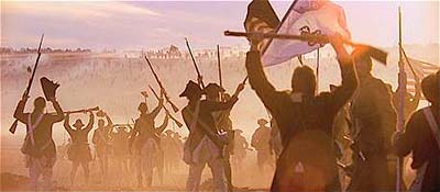
The Shawnee are defeated at Point Pleasant. The forced treaty insures more lands south of the Ohio are open to white settlement.
The Transylvania Company was organized Aug, 1774 as the Louisa Company, it was reorganized Jan, 1775 as the Transylvania Company. It was an association formed to exploit and colonize the area now comprising much of Kentucky and Tennessee. 17 March 1775 at Sycamore Shoals of the Watauga River, the Cherokee deeded to Richard Henderson and others, all the territory embraced by the Ohio, Kentucky, and Cumberland rivers. Henderson wanted to make Transylvania, as the region was called, a proprietary colony similar to Pennsylvania and Maryland, but the project did not have British approval and, more importantly, was immediately denounced by both Virginia and North Carolina, within whose chartered limits Transylvania lay. A provisional, democratic government was organized in May, 1775, but the Continental Congress ignored Henderson’s; plea for Transylvania to be recognized as the 14th colony.
Virginia created its Kentucky County in Dec, 1776, and then in Nov, 1778, voided the company’s; land titles there. Henderson then turned to the development of the Cumberland River area, employing James Robertson to lead this project. However, in 1783, North Carolina also voided this section of the grant. Virginia and North Carolina each awarded Henderson and his associates 200,000 acres for their labor and expenses.
The Henderson Purchase did involve Tennessee Land.
See 1919/21 Map Showing Location of Transylvania. (366k)
Richard Henderson, et al to Virginia Convention, 1776-77,
Memorial on Settlement of Ohio River Lands Purchased from Cherokee Indians
(Excerpt from page 1.)
. . . in fair and open treaty held with the Cherokee Nation of Tribe of Indians at Wataugah on the Seventeenth day of March in the year one thousand seven hundred and Seventy Five for a large and valuable Considerations obtained a grant for part of their lands lying on the River Ohio and branches thereof, to the Westward of the line lately run by Colonel Donelson, as a boundary between the Inhabitants of the Colony of Virginia and the said Cherokee . . .
Source : Library of Congress, American Memory, The Thomas Jefferson Papers
Richard Henderson, et al to Virginia Convention, 1776-77,
Memorial on Settlement of Ohio River Lands Purchased from Cherokee Indians
Deposition of Thomas Price
(Excerpt from pages 9 and 10.)
“. . . all that Tract, Territory or parcel of Land, situated lying & being in North America, on the Ohio River, one of the Eastern Branches of the Mississippi River beginning on the said Ohio River at the Mouth of the Kentucky, Chenosa or what by the English is called Louisa River, from thence running up the said River and the most Northwardly fork of the same to the to the head of a spring thereof, thence a south east to the top of a ridge of Powells Mountain thence Westwardly along the ridge of the said mountain unto a point from which a Northwest Course will hit or strike the head spring of the most Southwardly branch of the Cumberland River thence down the said River all its waters to the Ohio River thence up the said River as it meanders to the beginning . . .”
Source : Library of Congress, American Memory, The Thomas Jefferson Papers (Images 0756-811)
R. G. Thaites writes :
“Among Dr. [Lyman Copeland] Draper’s manuscripts I find this succinct review . . .”
“. . . It would appear from the historical evidences extant, that the Shawanoes were the earliest occupants of Kentucky of whom we have certain knowledge . . .
“. . . the Shawanoes departed from Kentucky [after 1673], and seem to have gone to the upper part of the Carolinas . . . [after losing a battle at Sandy Point in Ohio].
“It was this conquest that gave to the powerful Iroquois all the title they ever acquired to Kentucky. At the peace of Ryswick, in 1697, their right to the western conquests was fully acknowledged; and at the treaty of Lancaster, in Pennsylvania, in 1744, they ceded to Virginia all their lands west of that colony. In 1752, the Shawanoes and other western tribes, at Logstown on the Ohio, confirmed the Lancaster treaty, and sold their claim to the country south of the Ohio; and at the treaty of Fort Stanwix, in 1768, the Six Nations made a new cession of their claim to Kentucky as low as the Cherokee or Tennessee River. Up to this period, the Cherokee never so much as thought of contesting with the Iroquois their claim to the Kentucky Country; for some of the visiting Cherokee, while on their route to attend the Fort Stanwix treaty, killed some game for their subsistence, and on their arrival at Fort Stanwix tendered the skins to the Six Nations, saying, ‘They are yours, we killed them after passing the Big River,’ the name by which they had always designated the Tennessee. But probably discovering that other Indian nations were driving a good business by disposing of their distant land rights, the Cherokees managed to hatch up some sort of claim, which they, in part, relinquished to Virginia, at the treaty of Lochaber in 1770; and when Col. Donelson ran the line the following year, the boundary was fixed, at the suggestion of the Cherokee deputies, on the Kentucky River as the south-western line, as they delighted, they said, in natural landmarks. This considerably enlarged the cession, for which they received an additional compensation.
“In 1772, the Shawanoes made no claim to Kentucky; and at the treaty of Camp Charlotte, in October, 1774, they tacitly confirmed their old sale of that country in 1752, by agreeing not even to hunt south of the Ohio. Thus, then, we see that the Iroquois had twice ceded their right to Kentucky as low as the Tennessee River, and twice received their pay; the Shawanoes had disposed of their claim, such as it was, and received for it a valuable consideration; and the Cherokees, finding it profitable to lay claim to some valuable unoccupied region, sold their newly assumed right to the country south and east of Kentucky River. Their claim, if indeed it rises to the dignity of a claim, south and west of the Kentucky, was fairly purchased by Henderson and Company, and thus with the subsequent purchase by treaty, of the Chickasaws, of the strip between the Tennessee and Mississippi, the Indian title to the whole Kentucky country was fully and fairly extinguished.’
-R. G. T.
_____
Source : Chronicles of Border Warfare, or a History of the Settlement by the Whites, of North-Western Virginia, and of the Indian Wars and Massacres in that section of the State . . . &c.
By Alexander Scott Withers. Edited and Annotated by Reuben Gold Thaites, Secretary of the Wisconsin Historical Society, editor of “Wisconsin Historical Collection” etc.; New Edition, 1895 -- from the footnotes, pp 194-195
To See Full Text, Click Here
“In 1777 a treaty was concluded between Virginia and North Carolina on the one part, and the Cherokee on the other, by which the boundary and prohibitions as set forth in the act of the legislature of North Carolina are as follows:
“No person shall enter or survey any lands within the Indian hunting grounds, or within the limits heretofore ceded by them, which limits westward are declared to be as follows: Begin at a point on the dividing line which hath been agreed upon between the Cherokees and the colony of Virginia, where the line between that Commonwealth and this State (hereafter to be extended) shall intersect the same; running thence a right line to the mouth of Cloud’s Creek, being the second creek below Warrior’s Ford, at the mouth of Carter’s Valley; thence a right line to the highest point of Chimney Top Mountain or High Rock; thence a right line to the mouth of Camp or McNamee’s Creek, on the South Bank of Nolichucky, about ten miles below the mouth of Big Limestone; from the mouth of Camp a southeast course to the top of the great Iron Mountain, being the same which divides the hunting grounds of the Overhill Cherokees from the hunting grounds of the middle settlements; and from the top of Iron Mountain a south course to the dividing ridge between the waters of French Broad, and Nolichucky Rivers; thence a southwesterly course along the ridge of the Appalachian Mountains, which divide the eastern and western waters; thence with said dividing ridge to the line that divides the State of South Carolina from this State.”
_____
From : Indian Land Cessions in the United States, Compiled by Charles C. Royce. The 18th Annual Report of the Bureau of American Ethnology -- 1896-’97, Vol II, p 630.
The Revolutionary War marked the end of colonial treaties. The federal government became the authority to treat with the Indians. The third federal treaty, the Treaty of Hopewell, 28 Nov 1785 involved Tennessee lands and the Cherokee. Please visit our Indian Land Cessions in Tennessee Main Page to see the federal treaties in Tennessee.
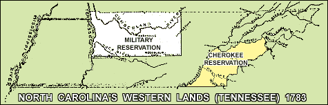
North Carolina’s 1783 Enlargement of its Western Boundary, &c. As the Revolutionary War drew to a close, North Carolina found itself short of money to pay its obligation to the North Carolina Officers and men who served in the continental line. In 1783, North Carolina determined to pay its debts with western land, and so passed acts that defined its bounds, limited the Cherokee, and created its Military Reservation.
“Beginning on the line which divided that state from Virginia, at a point due north of the mouth of Cloud’s Creek: running thence west to the Mississippi; thence down the Mississippi to the thirty-fifth degree of north latitude; thence due east, until it strikes the Apalachian Mountains; thence with the Apalachian Mountains to the ridge that divides the waters of French Broad River and the waters of Nollichucky River, and with that ridge, until it strikes the line described in the act of 1778., commonly called Brown’s Line, and with that line and those several water courses to the beginning.”
A Tract of Country was Reserved as Cherokee Hunting Grounds “Beginning at the Tennessee, where the southern boundary of North-Carolina intersects the same, [near Chattanooga, TN] nearest the Chickamauga Towns; thence up the middle Tennessee and Holston to the middle of French Broad River, which lines are not to include any island or islands in said river, to the mouth of the Big Pigeon River: thence up the same to the head thereof; thence along the dividing ridge between the waters of Pigeon River and Tuckasejah River, to the southern boundary of this state. ”( 1)
The North Carolina Military Reservation Located in north Middle Tennessee, this area was set aside for the Officers and men who served North Carolina during the Revolutionary War. The Military Reservation is described in the seventh section of an act of North Carolina, passed on 17 May 1783, entitled, “An act to amend an act, entitled, an act for the relief of the officers and soldiers in the continental line . . . ” The Military Reservation lines were: “...beginning on the Virginia [now Kentucky] line, where the Cumberland River intersects the same; thence south fifty-five miles; thence west, to the Tennessee River; thence down the Tennessee to the Virginia [Kentucky] line; thence with the said Virginia [Kentucky] line east, to the beginning. ”(2)(3)
The area in the Military Reservation north of the Cumberland River had been ceded by the Cherokee with the Henderson Purchase of 1775. South of the Cumberland was Cherokee land. The United States viewed all of North Carolina’s western lands as Indian lands except the tract north of the Cumberland River, and the early settlements in today’s northeast East Tennessee. However, North Carolina had a strict view about Cherokee land ownership, therefore they created the Cherokee Reservation. While the United States government had the final authority in Indian affairs, that did not stop North Carolina from issuing land grants for land within Indian territory.
John Rice received Grant No. 283 for 5,000 acres at Chickasaw Bluff (on the Mississippi River) in North Carolina’s Western District in 1783.(4) The Chickasaw claim for their West Tennessee land was not extinguished until 1818. This grant is typical of hundreds of grants that were issued for not-ceded Indian land, both Chickasaw and Cherokee. Although the grants could not be “taken up” until the Indian claim was extinguished, North Carolina continued to issue them. It is said that North Carolina was not receptive to Cherokee claims because the Cherokee were allied with the British during the Revolutionary War, so when the British lost, so did the Cherokee. To the victor goes the spoils. The Chickasaw were too far west to be an active concern of North Carolina. The creation of the independent State of Franklin was a political disruption to North Carolina but by the end of the 1780s, North Carolina relinquished her claims to western lands (but reserved the right to continue to issue grants there).
_____
1. Annals of Tennessee. J. G. M. Ramsey, M.D., 1853. Reprint 1967 by the East Tennessee Historical Society, Knoxville, TN, pp 275, 276.
(NC Assembly’s enactment of Chapter 2, Acts of 1783--Sec. III & V, May 1783)
2. Land Law of Tennessee. Henry D. Whitney. W. H. Anderson & Co. Law Book Publishers, Cincinnati Ohio, 1893. p. 195.
3. Ramsey, p. 491.
4. Earliest Tennessee Land Records & Earliest Tennessee Land History. Irene M. Griffey. Clearfield Company, Baltimore, Maryland, 2000. ISBN: 0-8063-5041-5
Article VI.No State, without the consent of the United States in Congress assembled, shall send any embassy to, or receive any embassy from, or enter into any conference, agreement, alliance or treaty with any King, Prince or State; nor shall any person holding any office of profit or trust under the United States, or any of them, accept any present, emolument, office or title of any kind whatever from any King, Prince or foreign State; nor shall the United States in Congress assembled, or any of them, grant any title of nobility.
No two or more States shall enter into any treaty, confederation or alliance whatever between them, without the consent of the United States in Congress assembled, specifying accurately the purposes for which the same is to be entered into, and how long it shall continue . . .
Article VI.. . . The United States in Congress assembled shall also have the sole and exclusive right and power of regulating the alloy and value of coin struck by their own authority, or by that of the respective States -- fixing the standards of weights and measures throughout the United States -- regulating the trade and managing all affairs with the Indians, not members of any of the States, provided that the legislative right of any State within its own limits be not infringed or violated -- establishing or regulating post offices from one State to another, throughout all the United States, and exacting such postage on the papers passing through the same as may be requisite to defray the expenses of the said office -- appointing all officers of the land forces, in the service of the United States, excepting regimental officers -- appointing all the officers of the naval forces, and commissioning all officers whatever in the service of the United States -- making rules for the government and regulation of the said land and naval forces, and directing their operations.
By the UNITED STATES in
CONGRESS assembled.
AUGUST 7, 1786.
An ORDINANCE for the Regulation of INDIAN AFFAIRSWHEREAS the safety and tranquillity of the frontiers of the United States, do in some measure, depend on the maintaining a good correspondence between their citizens and the several nations of Indians in amity with them: And whereas the United States in Congress assembled, under the ninth of the articles of confederation and perpetual union, have the sole and exclusive right and power of regulating the trade, and managing all affairs with the Indians not members of any states; provided that the legislative right of any state within its own limits be not infringed or violated.
Be it ordained by the United States in Congress assembled, That from and after the passing of this ordinance, the Indian department be divided into two districts, viz. The southern, which shall comprehend within its limits, all the nations in the territory of the United States, who reside southward of the river Ohio; and the northern, which shall comprehend all the other Indian nations within the said territory, and westward of Hudson river: Provided that all councils, treaties, communications and official transactions, between the superintendant hereafter mentioned for the northern district, and the Indian nations, be held, transacted and done, at the outpost occupied by the troops of the United States, in the said district. That a superintendant be appointed for each of the said districts, who shall continue in office for two years, unless sooner removed by Congress, and shall reside within or as near the district for which he shall be so appointed, as may be convenient for the management of its concerns. The said superintendants, shall attend to the execution of such regulations, as Congress shall from time to time establish respecting Indian affairs. The superintendant for the northern district, shall have authority to appoint two deputies, to reside in such places as shall best facilitate the regulations of the Indian trade, and to remove them for misbehaviour. There shall be a communications of all matters relative to the business of the Indian department, kept up between the said superintendants, who shall regularly correspond with the secretary at war, through whom all communications respecting the Indian department, shall be made to Congress; and the superintendants are hereby directed to obey all instructions, which they shall from time to time receive from the said secretary at war. And whenever they shall have reason to suspect, any tribe or tribes of Indians, of hostile intentions, they shall communicate cases, the same to the executive of the state or states, whose territories are subject to the effect of such hostilities. All stores, provisions or other property, which Congress may think necessary for presents to the Indians, shall be in the custody and under the care of the said superintendants, who shall render an annual account of the expenditures of the same, to the Board of Treasury.
And be it further ordained, That none but citizens of the United States, shall be suffered to reside among the Indian nations, or be allowed to trade with any nation of Indians, within the territory of the United States. That no person, citizen or other, under the penalty of five hundred dollars, shall reside among or trade with any Indian or Indian nation, within the territory of the United States, without a license for that purpose first obtained from the superintendant of the district, or one of the deputies, who are hereby directed to give such license to every person, who shall produce from the supreme executive of any state, a certificate under the seal of the state, that he is of good character and suitably qualified, and provided for that employment, for which license he shall pay the sum of fifty dollars to the said superintendant for the use of the United States. That no license to trade with the Indians shall be in force for a longer term than one year; nor shall permits or passports be granted to any other persons than citizens of the United States to travel through the Indian nations, without their having previously made their business known to the superintendant of the district, and received his special approbation. That previous to any person or persons obtaining a license to trade as aforesaid, he or they shall give bond in three thousand dollars to the superintendant of the district, for the use of the United States, for his or their strict adherence to, and observance of such rules and regulations as Congress may from time to time establish for the government of the Indian trade. All sums to be received by the said superintendants, either for licenses or fines, shall be annually accounted for by them with the board of treasury.
And be it further ordained, That the said superintendants, and the deputies, shall not be engaged, either directly or indirectly in trade with the Indians, on pain of forfeiting their offices, and each of the superintendants shall take the following oath, previous to his entering on the duties of his appointment---“I, A.B. do swear, that I will well and faithfully serve the United States in the office of superintendant of Indian affairs, for the . . . district: That I will carefully attend to all such orders and instructions as I shall from time to time receive from the United States in Congress assembled, or the secretary at war: That I will not be concerned, either directly or indirectly in trade with the Indians, and that in all things belonging to my said office, during my continuance therein, I will faithfully, justly and truly, according to the best of my skill and judgment, do equal and impartial justice, without fraud, favour or affection.” And the superintendant for the northern district, shall administer to his deputies, the following oath, before they proceed on the duties of their office, “I, A.B. do swear, that I will well and faithfully serve the United States, in the office of deputy superintendant of Indian affairs in the northern district, that I will carefully attend to all such orders and instructions as I shall from time to time receive from the United States in Congress assembled, the secretary at war, or the superintendant of the district aforesaid, and that in all things belonging to my said office, during my continuance therein, I will faithfully, justly and truly, according to the best of my skill and judgment, do equal and impartial justice, without fraud, favor or affection.” And the said superintendants, and deputy-superintendants, shall each of them give bond with surety to the board of treasury, in trust for the United States; the superintendants each in the sum of six thousand dollars, and the deputy-superintendants each in the sum of three thousand dollars, for the faithful discharge of the duties of their office.
And it is further ordained, That all fines and forfeitures which may be incurred by contravening this ordinance, shall be sued for and recovered before any court of record within the United States, the one moiety thereof to the use of him or them who may prosecute therefor, and the other moiety to the use of the United States. And the said superintendants shall have power, and hereby are authorised, by force to restrain therefrom, all persons who shall attempt an intercourse with the said Indians without a license therefor obtained as aforesaid.
And be it further ordained, That in all cases where transactions with any nation or tribe of Indians shall become necessary to the purposes of this ordinance, which cannot be done without interfering with the legislative rights of a state, the superintendant in whose district the same shall happen, shall act in conjunction with the authority of such state. Done, &c.
Article I, Section. 10
No State shall enter into any Treaty, Alliance, or Confederation; grant Letters of Marque and Reprisal; coin Money; emit Bills of Credit; make any Thing but gold and silver Coin a Tender in Payment of Debts; pass any Bill of Attainder, ex post facto Law, or Law impairing the Obligation of Contracts, or grant any Title of Nobility.
. . . Year of our Lord one thousand seven hundred and Eighty seven and of the Independence of the United States of America the Twelfth
After the Revolutionary War, settlers in north-east East Tennessee attempted to form a state they named Franklin (a.k.a. Frankland) in what was North Carolina’s Western Lands. To read more about Franklin’s history, please visit our State of Franklin page.”
East Tennesseans from the State of Franklin negotiated this treaty with the Cherokee, however, it was not recognized by North Carolina. “It is agreed by us, the warriors, chiefs and representatives of the Cherokee Nation that all the lands lying and being on the South side of the Holston and French Broad rivers, as far South as the ridge that divides the water of Little River from the waters of Tennessee may be peaceably inhabited and cultivated, resided on, enjoyed and inhabited by our elder brothers, the white people, from this time forward and always.”
Colonial Period Indian Land Cessions In Tennessee, Part One
The Aboriginal People of Tennessee to King George III & Company, 1768
Indian Land Cessions
Home Page
This page last updated on
Page © 2001-2007 TNGenNet Inc